Trail Walking Vallauris - Darboussières Golfe-Juan retour Mauruches - Photo

Darboussières Golfe-Juan retour Mauruches

© OpenStreetMap contributors
Length
Length
8.5 km
Max alt
Max alt
209 m
Uphill gradient
Uphill gradient
246 m
Km-Effort
Km-Effort  
11.8 km
Min alt
Min alt
1 m
Downhill gradient
Downhill gradient
246 m
Boucle
Boucle
Yes
Creation date :
2014-12-10 00:00:00.0
Updated on :
2014-12-10 00:00:00.0

(1 Reviews)

Walking
Walking
1h55
Difficulty : Easy

Scan this QR Code to open this trail in the SityTrail application

FREE GPS app for hiking

Logo SityTrail SityTrail

IGN / Geographical institutes

Download SityTrail from the App Store Download SityTrail from Google Play

Logo SityTrail SityTrail World

The world is yours!

Download SityTrail from the App Store Download SityTrail from Google Play Download SityTrail on Huawei AppGallery

About

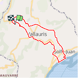
Trail Walking of 8.5 km to be discovered at Provence-Alpes-Côte d'Azur, Maritime Alps, Vallauris. This trail is proposed by pjjrevrard.

Elevation profile

Positioning

Country:
France
Region :
Provence-Alpes-Côte d'Azur
Department/Province :
Maritime Alps
Municipality :
Vallauris
Location:
Unknown
Start:(UTM)
342276 ; 4827063 (32T) N.

Comments

Please log in to post a review or rate the element


bcp de route goudronnée et de changement de trotoire


Trails nearby

Trail Cycle Cannes - st michel to funicular - Photo
Cycle
norman0000

Cycle

Very easy
(1)
Cannes, Provence-Alpes-Côte d'Azur, Maritime Alps, France
5.3 km | 7.3 km-effort
33min
Yes
Trail On foot Valbonne - Circuit des Bouillides - Photo
On foot
PRO

On foot

Easy
Valbonne, Provence-Alpes-Côte d'Azur, Maritime Alps, France
10.6 km | 13.9 km-effort
3h 8min
Yes
Trail On foot Valbonne - Circuit de l'Aqueduc - Photo
On foot
PRO

On foot

Easy
Valbonne, Provence-Alpes-Côte d'Azur, Maritime Alps, France
6.3 km | 8 km-effort
1h 49min
Yes
Trail Mountain bike Valbonne - Valmasques pistes carton, Devens, des Moulins... - Photo
Mountain bike
GrouGary

Mountain bike

Easy
(2)
Valbonne, Provence-Alpes-Côte d'Azur, Maritime Alps, France
12.4 km | 15.3 km-effort
1h 53min
Yes
Trail Walking Le Cannet - Sur les pas de Bonnard, Le Cannet - Photo
Walking
GrouGary

Walking

Very easy
(1)
Le Cannet, Provence-Alpes-Côte d'Azur, Maritime Alps, France
4.8 km | 6.3 km-effort
1h 44min
Yes
Trail On foot Biot - Promenade des Colles - Photo
On foot
PRO

On foot

Easy
Biot, Provence-Alpes-Côte d'Azur, Maritime Alps, France
3.6 km | 4.6 km-effort
1h 3min
Yes
Trail Walking Vallauris - Golfe-Juan Antibes gare à gare - Photo
Walking
pjjrevrard

Walking

Easy
(1)
Vallauris, Provence-Alpes-Côte d'Azur, Maritime Alps, France
10.2 km | 12.2 km-effort
2h 32min
No
Trail Walking Vallauris - VALLAURIS . CITE ANTIQUE DE LA CORDULA O - Photo
Walking
RobinMicheline

Walking

Medium
Vallauris, Provence-Alpes-Côte d'Azur, Maritime Alps, France
5.9 km | 7.7 km-effort
1h 50min
Yes
Trail Walking Mougins - Circuit de Fugureit - Photo
Walking
jwo47

Walking

Easy
Mougins, Provence-Alpes-Côte d'Azur, Maritime Alps, France
4.5 km | 5.9 km-effort
1h 21min
Yes


Close
My subscriptions