Trail Walking Rimbachzell - mp Rimbachzell 2019 - Photo

mp Rimbachzell 2019

 stempfel52
stempfel52

User GUIDE

© OpenStreetMap contributors
Length
Length
11.9 km
Max alt
Max alt
542 m
Uphill gradient
Uphill gradient
363 m
Km-Effort
Km-Effort  
16.7 km
Min alt
Min alt
323 m
Downhill gradient
Downhill gradient
364 m
Boucle
Boucle
Yes
Creation date :
2019-09-28 08:35:08.285
Updated on :
2020-03-12 12:43:55.964

(0 Reviews)

Walking
Walking
3h07
Difficulty : Medium

Scan this QR Code to open this trail in the SityTrail application

FREE GPS app for hiking

Logo SityTrail SityTrail

IGN / Geographical institutes

Download SityTrail from the App Store Download SityTrail from Google Play

Logo SityTrail SityTrail World

The world is yours!

Download SityTrail from the App Store Download SityTrail from Google Play Download SityTrail on Huawei AppGallery

About

Trail Walking of 11.9 km to be discovered at Grand Est, Haut-Rhin, Rimbachzell. This trail is proposed by stempfel52.

Elevation profile

Photos

Positioning

Country:
France
Region :
Grand Est
Department/Province :
Haut-Rhin
Municipality :
Rimbachzell
Location:
Unknown
Start:(UTM)
363790 ; 5306724 (32T) N.

Trails nearby

Trail Walking Soultz-Haut-Rhin - Hartmannswillerkopf - Circuit découverte - Photo
Walking
VacheKiri67

Walking

Easy
(1)
Soultz-Haut-Rhin, Grand Est, Haut-Rhin, France
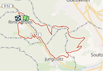
3.6 km | 5.2 km-effort
1h 46min
Yes
Trail Walking Soultz-Haut-Rhin - Hartmannswillerkopf - Circuit anneau bleu - Photo
Walking
VacheKiri67

Walking

Medium
(1)
Soultz-Haut-Rhin, Grand Est, Haut-Rhin, France
3.7 km | 5.9 km-effort
1h 37min
Yes
Trail On foot Goldbach-Altenbach - Firstacker - Willer sur Thur - Photo
On foot
PRO

On foot

Easy
Goldbach-Altenbach, Grand Est, Haut-Rhin, France
7.4 km | 9.6 km-effort
2h 11min
No
Trail Trail Wattwiller - The History Ultra - stage 1 - Photo
Trail
Olivier Houette

Trail

Very easy
(1)
Wattwiller, Grand Est, Haut-Rhin, France
28 km | 48 km-effort
Unknown
No
Trail Walking Soultz-Haut-Rhin - Rando Marcheurs..04/04_2025 - Photo
Walking
boubou68

Walking

Very difficult
Soultz-Haut-Rhin, Grand Est, Haut-Rhin, France
21 km | 35 km-effort
4h 42min
Yes
Trail Walking Jungholtz - Rando Retrouvailles...01/03/2024.par Jean Marc - Photo
Walking
boubou68

Walking

Very difficult
Jungholtz, Grand Est, Haut-Rhin, France
11.3 km | 19.2 km-effort
1h 35min
Yes
Trail Walking Murbach - La
Walking
boubou68

Walking

Very difficult
Murbach, Grand Est, Haut-Rhin, France
14.7 km | 28 km-effort
4h 3min
Yes
Trail Walking Murbach - Murbach - Photo
Walking
oscar1

Walking

Difficult
Murbach, Grand Est, Haut-Rhin, France
15.4 km | 25 km-effort
4h 25min
Yes
Trail Walking Soultz-Haut-Rhin - Rando avec 0mar et Mouloud..18/02/2023 - Photo
Walking
boubou68

Walking

Very difficult
Soultz-Haut-Rhin, Grand Est, Haut-Rhin, France
12 km | 20 km-effort
3h 9min
Yes


Close
My subscriptions