Trail Mountain bike Dinant - Circuit VTT mauve - Photo

Circuit VTT mauve

© OpenStreetMap contributors
Length
Length
21 km
Max alt
Max alt
256 m
Uphill gradient
Uphill gradient
420 m
Km-Effort
Km-Effort  
27 km
Min alt
Min alt
90 m
Downhill gradient
Downhill gradient
420 m
Boucle
Boucle
Yes
Creation date :
2019-10-08 11:37:35.624
Updated on :
2019-10-08 11:45:28.785

(0 Reviews)

Mountain bike
Mountain bike
2h40
Difficulty : Difficult

Scan this QR Code to open this trail in the SityTrail application

FREE GPS app for hiking

Logo SityTrail SityTrail

IGN / Geographical institutes

Download SityTrail from the App Store Download SityTrail from Google Play

Logo SityTrail SityTrail World

The world is yours!

Download SityTrail from the App Store Download SityTrail from Google Play Download SityTrail on Huawei AppGallery

About

Trail Mountain bike of 21 km to be discovered at Wallonia, Namur, Dinant. This trail is proposed by ValleedelaMeuse.

Description

Le circuit longe la Meuse. Au rocher Bayard,il y a une montée vers Dréhance par "Dinant évasion". Descente sur la Lesse par les aiguilles de Chaleux puis effectuez un retour à Anseremme. Il faut alors traverser l'écluse puis monter sur la réserve de Moniat pour enfin redescendre à Dinant.

Elevation profile

Positioning

Country:
Belgium
Region :
Wallonia
Department/Province :
Namur
Municipality :
Dinant
Location:
Dinant
Start:(UTM)
636154 ; 5569353 (31U) N.

Trails nearby

Trail Walking Dinant - RB-Na-24-Entre Lesse et Meuse - Photo
Walking
PRO

Walking

Medium
(14)
Dinant, Wallonia, Namur, Belgium
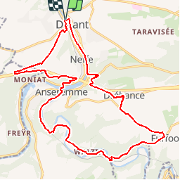
19.2 km | 26 km-effort
5h 34min
Yes
Trail Walking Yvoir - RB-Na-03 Forteresses, citadelle et abbaye mosanes - Photo
Walking
PRO

Walking

Difficult
(10)
Yvoir, Wallonia, Namur, Belgium
22 km | 30 km-effort
7h 1min
Yes
Trail Walking Onhaye - RB-Na-C2-Sommière-Complet_20,4km - Photo
Walking
PRO

Walking

Very difficult
(2)
Onhaye, Wallonia, Namur, Belgium
20 km | 25 km-effort
5h 25min
Yes
Trail Walking Dinant - Balade à Dinant - La Réserve Naturelle de Moniat - Photo
Walking
GUIDE
Desrumaux

Walking

Very easy
(1)
Dinant, Wallonia, Namur, Belgium
8.4 km | 10.9 km-effort
3h 54min
Yes
Trail Walking Dinant - D'Anseremme à Dinant - Photo
Walking
GUIDE
Desrumaux

Walking

Easy
(3)
Dinant, Wallonia, Namur, Belgium
8.3 km | 11.8 km-effort
2h 34min
Yes
Trail Walking Dinant - Balade à Bouvignes - Photo
Walking
GUIDE
Desrumaux

Walking

Easy
(3)
Dinant, Wallonia, Namur, Belgium
4.8 km | 7.2 km-effort
1h 34min
Yes
Trail Walking Dinant - Balade en Réserve Naturelle de Devant Bouvignes - Photo
Walking
GUIDE
Desrumaux

Walking

Very easy
(3)
Dinant, Wallonia, Namur, Belgium
4.9 km | 6.9 km-effort
1h 32min
Yes
Trail Walking Dinant - Dinant: autour de la Citadelle.  - Photo
Walking
godi

Walking

Easy
(4)
Dinant, Wallonia, Namur, Belgium
5.7 km | 7.5 km-effort
1h 40min
Yes
Trail Walking Onhaye - RB-Na-C2-Sommière-Raccourci_13,1km - Photo
Walking
PRO

Walking

Difficult
(5)
Onhaye, Wallonia, Namur, Belgium
13 km | 16.2 km-effort
3h 29min
Yes


Close
My subscriptions