Trail Walking Vineuil - 23 km Vineuil-Montlivault - Photo

23 km Vineuil-Montlivault

 domlecar
domlecar

User

© OpenStreetMap contributors
Length
Length
23 km
Max alt
Max alt
86 m
Uphill gradient
Uphill gradient
130 m
Km-Effort
Km-Effort  
25 km
Min alt
Min alt
64 m
Downhill gradient
Downhill gradient
129 m
Boucle
Boucle
Yes
Creation date :
2014-12-10 00:00:00.0
Updated on :
2014-12-10 00:00:00.0

(1 Reviews)

Walking
Walking
5h00
Difficulty : Easy

Scan this QR Code to open this trail in the SityTrail application

FREE GPS app for hiking

Logo SityTrail SityTrail

IGN / Geographical institutes

Download SityTrail from the App Store Download SityTrail from Google Play

Logo SityTrail SityTrail World

The world is yours!

Download SityTrail from the App Store Download SityTrail from Google Play Download SityTrail on Huawei AppGallery

About

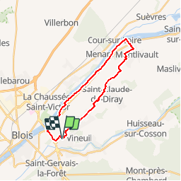
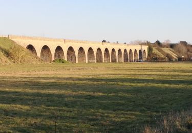
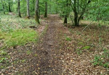
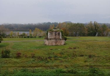
Trail Walking of 23 km to be discovered at Centre-Loire Valley, Loir-et-Cher, Vineuil. This trail is proposed by domlecar.

Description

23km
Bords de Loire jusqu'à Montlivault
Retour par les villages

Elevation profile

Positioning

Country:
France
Region :
Centre-Loire Valley
Department/Province :
Loir-et-Cher
Municipality :
Vineuil
Location:
Unknown
Start:(UTM)
377700 ; 5271524 (31T) N.

Comments

Please log in to post a review or rate the element


Trails nearby

Trail On foot Huisseau-sur-Cosson - Château de Nanteuil - Photo
On foot
PRO

On foot

Easy
Huisseau-sur-Cosson, Centre-Loire Valley, Loir-et-Cher, France
9.8 km | 10.8 km-effort
2h 27min
Yes
Trail Walking Vineuil - Loire 2 - Photo
Walking
domlecar

Walking

Very easy
(1)
Vineuil, Centre-Loire Valley, Loir-et-Cher, France
18.2 km | 19.5 km-effort
2h 46min
Yes
Trail Walking Vineuil - Vineuil le viaduc via la Noue Château de Ménard  - Photo
Walking
jouhan

Walking

Medium
Vineuil, Centre-Loire Valley, Loir-et-Cher, France
11.9 km | 12.5 km-effort
2h 30min
Yes
Trail Walking Saint-Gervais-la-Forêt - Saint-Gervais-la-Forêt - Chailles - Photo
Walking
guydu41

Walking

Easy
Saint-Gervais-la-Forêt, Centre-Loire Valley, Loir-et-Cher, France
9.1 km | 11.4 km-effort
2h 43min
Yes
Trail Walking Saint-Claude-de-Diray - St Claude de diray - Photo
Walking
Gablier

Walking

Very easy
Saint-Claude-de-Diray, Centre-Loire Valley, Loir-et-Cher, France
12.6 km | 13.5 km-effort
2h 39min
Yes
Trail Walking Saint-Claude-de-Diray - St Claude de Diray  - Photo
Walking
Gablier

Walking

Very easy
Saint-Claude-de-Diray, Centre-Loire Valley, Loir-et-Cher, France
11.8 km | 12.7 km-effort
3h 2min
Yes
Trail Hybrid bike Blois - Blois Chambord et retour - Photo
Hybrid bike
tbrunet

Hybrid bike

Easy
Blois, Centre-Loire Valley, Loir-et-Cher, France
49 km | 54 km-effort
5h 13min
Yes
Trail Walking Blois - blois - Photo
Walking
pistou

Walking

Medium
Blois, Centre-Loire Valley, Loir-et-Cher, France
5.6 km | 6.4 km-effort
4h 10min
No
Trail Walking Saint-Gervais-la-Forêt - La Chaussée St Victor  - Photo
Walking
mimilolo

Walking

Very easy
Saint-Gervais-la-Forêt, Centre-Loire Valley, Loir-et-Cher, France
13.5 km | 15.7 km-effort
2h 44min
Yes


Close
My subscriptions