Trail Other activity Lenk - Wildhorn tour - Photo
 Bachmann
Bachmann

User

© OpenStreetMap contributors
Length
Length
38 km
Max alt
Max alt
3009 m
Uphill gradient
Uphill gradient
3372 m
Km-Effort
Km-Effort  
83 km
Min alt
Min alt
1589 m
Downhill gradient
Downhill gradient
3353 m
Boucle
Boucle
Yes
Creation date :
2014-12-11 00:00:00.0
Updated on :
2014-12-11 00:00:00.0

(0 Reviews)

Other activity
Other activity
--
Difficulty : Unknown

Scan this QR Code to open this trail in the SityTrail application

FREE GPS app for hiking

Logo SityTrail SityTrail

IGN / Geographical institutes

Download SityTrail from the App Store Download SityTrail from Google Play

Logo SityTrail SityTrail World

The world is yours!

Download SityTrail from the App Store Download SityTrail from Google Play Download SityTrail on Huawei AppGallery

About

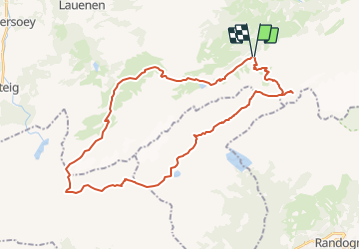
Trail Other activity of 38 km to be discovered at Bern, Obersimmental-Saanen administrative district, Lenk. This trail is proposed by Bachmann.

Description

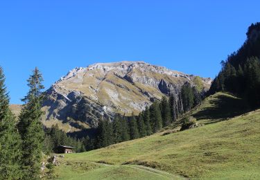
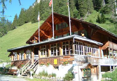
Tour de 2 ou 4 jours, départ d''Iffigenalp (dernier tronçon trafic réglementé, départ pour la montée de h 15 à h 30min, pour la descente de l''h à h 15). Etapes aux cabanes du Wildsrtubel (si 4 jours), des Audannes et de Gelten (4 jours). Variante possible, plus courte et plus dure, par la cabane du Wildhorn et le Schnidejoch sur le lac de Ténéhet. Ambiance austère, très belles vues, lapiaz à gogo avant et après le lac de Ténéhet.
Temps de parcours réalisé en 2 jours: 17h40 y compris les arrêts : 6h10 et 11h30.
Descente de l''Arpelistock sur la neige (glacier).

Elevation profile

Positioning

Country:
Switzerland
Region :
Bern
Department/Province :
Obersimmental-Saanen administrative district
Municipality :
Lenk
Location:
Unknown
Start:(UTM)
380191 ; 5139700 (32T) N.

Trails nearby

Trail Walking Crans-Montana - Sentier de Huiton - Photo
Walking
GUIDE+

Walking

Very easy
(2)
Crans-Montana, Valais/Wallis, Sierre, Switzerland
7.1 km | 10.9 km-effort
2h 17min
No
Trail On foot Lenk - Lenk (Ritzdole) - Lenk (Simmenfälle) - Photo
On foot
PRO

On foot

Easy
Lenk, Bern, Obersimmental-Saanen administrative district, Switzerland
8.2 km | 14.6 km-effort
3h 19min
No
Trail On foot Lenk - Iffigenalp-Stierenläger - Photo
On foot
PRO

On foot

Easy
Lenk, Bern, Obersimmental-Saanen administrative district, Switzerland
3.3 km | 10.3 km-effort
2h 20min
No
Trail Walking Lenk - Tour du Wildhorn, jour 4 - Photo
Walking
GUIDE+

Walking

Very easy
Lenk, Bern, Obersimmental-Saanen administrative district, Switzerland
11.4 km | 25 km-effort
6h 0min
No
Trail Walking Lenk - Tour du Wildhorn, jour 3 - Photo
Walking
GUIDE+

Walking

Very easy
Lenk, Bern, Obersimmental-Saanen administrative district, Switzerland
10.2 km | 25 km-effort
6h 0min
No
Trail Walking Lenk - sf10_e9b - Photo
Walking
GUIDE+

Walking

Very easy
Lenk, Bern, Obersimmental-Saanen administrative district, Switzerland
8.5 km | 23 km-effort
4h 53min
No
Trail Walking Lenk - st_wildstrubel_sanetsch - Photo
Walking
GUIDE+

Walking

Very easy
Lenk, Bern, Obersimmental-Saanen administrative district, Switzerland
24 km | 42 km-effort
Unknown
No
Trail Snowshoes Lenk - iffighore - Photo
Snowshoes
yvz

Snowshoes

Easy
Lenk, Bern, Obersimmental-Saanen administrative district, Switzerland
6 km | 17 km-effort
2h 58min
No
Trail Walking Crans-Montana - Montana, La Plaine Morte - Photo
Walking
rpf

Walking

Very easy
Crans-Montana, Valais/Wallis, Sierre, Switzerland
8.8 km | 13.6 km-effort
4h 30min
No


Close
My subscriptions