


Amiens

VANDERPUTTENMi
User GUIDE
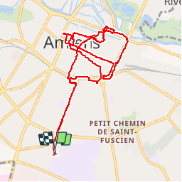

Length
12.5 km

Max alt
69 m

Uphill gradient
119 m
Km-Effort
14 km

Min alt
22 m

Downhill gradient
121 m
Boucle
Yes
Creation date :
2019-11-30 12:47:14.007
Updated on :
2019-11-30 19:30:03.209
4h22
Difficulty : Very easy

FREE GPS app for hiking
 SityTrail
IGN / Geographical institutes
SityTrail Plus
The world is yours!
About
Trail Walking of 12.5 km to be discovered at Hauts-de-France, Somme, Amiens. This trail is proposed by VANDERPUTTENMi.
Description
Amiens Lumière
Positioning
Country:
France
Region :
Hauts-de-France
Department/Province :
Somme
Municipality :
Amiens
Location:
Unknown
Start:(Dec)
Start:(UTM)
449101 ; 5525149 (31U) N.
Comments