Trail Walking Vallorbe - Das Tal von Jougnena - Photo
 vallorbe
vallorbe

User

© OpenStreetMap contributors
Length
Length
25 km
Max alt
Max alt
965 m
Uphill gradient
Uphill gradient
717 m
Km-Effort
Km-Effort  
34 km
Min alt
Min alt
741 m
Downhill gradient
Downhill gradient
621 m
Boucle
Boucle
No
Creation date :
2014-12-11 00:00:00.0
Updated on :
2014-12-11 00:00:00.0

(0 Reviews)

Walking
Walking
5h40
Difficulty : Unknown

Scan this QR Code to open this trail in the SityTrail application

FREE GPS app for hiking

Logo SityTrail SityTrail

IGN / Geographical institutes

Download SityTrail from the App Store Download SityTrail from Google Play

Logo SityTrail SityTrail World

The world is yours!

Download SityTrail from the App Store Download SityTrail from Google Play Download SityTrail on Huawei AppGallery

About

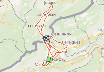
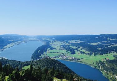
Trail Walking of 25 km to be discovered at Vaud, District du Jura-Nord vaudois, Vallorbe. This trail is proposed by vallorbe.

Description

Start in Jougne bei der Post, Richtung Entre-les-Fourgs.
Tafel 1 bis Tafel 2: Man wandert auf einem schattigen Weg rechts der Strasse, der schnell zur Kapelle St-Maurice hinabführt
Tafel 2 bis Tafel 3: Auf der Teerstrasse in Le Moulin geht es Richtung Fischzucht
Tafel 3 bis Tafel 4: Die Strasse folgt dem Fluss bis zu einem Wasserfall auf der linken Seite.
An der Kreuzung haben Sie zwei Möglichkeiten: Entweder nehmen Sie eine der beiden Abkürzungen, um nach Jougne zurückzugelangen, oder Sie folgen der Tafel 4 links in Richtung der Teiche.
Tafel 4 bis Tafel 5: Links einen grossen Platz (einst Lagerplatz für Holz) überqueren, um über eine Fussgängerbrücke über die Jougnena zu gelangen, wo ein sehr schattiger Weg steil nach Les Echampés hinaufsteigt. Sobald man aus dem Wald auf die Felder kommt, ist auf der rechten Seite hinter den letzten Häusern der Weg zum Grenzübergang erkennbar. Die letzten Meter sind oft schlammig.
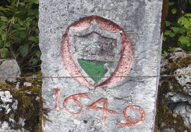
Tafel 5 bis 6: Etwa 300 m hinter der Grenze besteht an der Kreuzung Chez Thouny (auf der Schweizer Seite) die letzte Möglichkeit, die Wanderung abzukürzen.

In unserem Fremdenverkehsamt, werden Sie eine Broschüre auf den Tal von Jougnena mit historischen Erklärungen.

Elevation profile

Points of interest

Point of interest Vallorbe - Vallorbe - Photo
vallorbe
VALLORBE 
Point of interest Vallorbe - Table 8 - Photo
vallorbe
VALLORBE 
Point of interest Ballaigues - Table 7 - Photo
vallorbe
BALLAIGUES 
Point of interest Ballaigues - Table 5 - Photo
vallorbe
BALLAIGUES 
Point of interest Ballaigues - Table 6 - Photo
vallorbe
BALLAIGUES 
Point of interest Jougne - Table 4 - Photo
vallorbe
JOUGNE 
Point of interest Jougne - Table 3 - Photo
vallorbe
JOUGNE 
Point of interest Jougne - Table 2 - Photo
vallorbe
JOUGNE 
Point of interest Jougne - Table 1 - Photo
vallorbe
JOUGNE 
Point of interest Vallorbe - Table 9 - Photo
vallorbe
VALLORBE 
Point of interest Jougne - Raccourci 1 - Photo
vallorbe
JOUGNE 

Positioning

Country:
Switzerland
Region :
Vaud
Department/Province :
District du Jura-Nord vaudois
Municipality :
Vallorbe
Location:
Unknown
Start:(UTM)
299979 ; 5176363 (32T) N.

Trails nearby

Trail Mountain bike Vallorbe - Le Suchet - Photo
Mountain bike
GUIDE+

Mountain bike

Very easy
(1)
Vallorbe, Vaud, District du Jura-Nord vaudois, Switzerland
35 km | 53 km-effort
14h 41min
Yes
Trail On foot Vallorbe - Mont d'Orzeires - Le Pont Gare - Photo
On foot
PRO

On foot

Easy
Vallorbe, Vaud, District du Jura-Nord vaudois, Switzerland
3.2 km | 4.4 km-effort
59min
No
Trail On foot Ballaigues - Ballaigues-Vallorbe - Photo
On foot
PRO

On foot

Easy
Ballaigues, Vaud, District du Jura-Nord vaudois, Switzerland
5.1 km | 6.3 km-effort
1h 25min
No
Trail On foot Vallorbe - Saigne Geret-Les Revines - Photo
On foot
PRO

On foot

Easy
Vallorbe, Vaud, District du Jura-Nord vaudois, Switzerland
3.5 km | 4.1 km-effort
56min
No
Trail On foot Juriens - TP Mollendruz - Romainmôtie - Photo
On foot
PRO

On foot

Easy
Juriens, Vaud, District du Jura-Nord vaudois, Switzerland
7.8 km | 11.6 km-effort
2h 38min
No
Trail Walking L'Abbaye - La Dent de Vaulion - Photo
Walking
drarep

Walking

Very difficult
(1)
L'Abbaye, Vaud, District du Jura-Nord vaudois, Switzerland
14.6 km | 22 km-effort
4h 31min
Yes
Trail Walking Rochejean - Mont d'or  - Photo
Walking
eltonnermou

Walking

Easy
Rochejean, Bourgogne-Franche-Comté, Doubs, France
11.9 km | 17.5 km-effort
4h 53min
Yes
Trail Walking Jougne - La Jougnena - Photo
Walking
daniellebou

Walking

Very difficult
(1)
Jougne, Bourgogne-Franche-Comté, Doubs, France
17.7 km | 24 km-effort
5h 32min
Yes
Trail Snowshoes Longevilles-Mont-d'Or - Les Longevilles Mont D'Or CAF - Photo
Snowshoes
TRIMAILLE

Snowshoes

Medium
(1)
Longevilles-Mont-d'Or, Bourgogne-Franche-Comté, Doubs, France
8.4 km | 13 km-effort
8h 27min
Yes


Close
My subscriptions