Trail Walking Vallorbe - Rundfahrt des Festung - Photo
 vallorbe
vallorbe

User

© OpenStreetMap contributors
Length
Length
7.6 km
Max alt
Max alt
1031 m
Uphill gradient
Uphill gradient
341 m
Km-Effort
Km-Effort  
12.2 km
Min alt
Min alt
748 m
Downhill gradient
Downhill gradient
340 m
Boucle
Boucle
Yes
Creation date :
2014-12-11 00:00:00.0
Updated on :
2014-12-11 00:00:00.0

(0 Reviews)

Walking
Walking
2h30
Difficulty : Unknown

Scan this QR Code to open this trail in the SityTrail application

FREE GPS app for hiking

Logo SityTrail SityTrail

IGN / Geographical institutes

Download SityTrail from the App Store Download SityTrail from Google Play

Logo SityTrail SityTrail World

The world is yours!

Download SityTrail from the App Store Download SityTrail from Google Play Download SityTrail on Huawei AppGallery

About

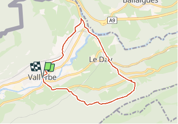
Trail Walking of 7.6 km to be discovered at Vaud, District du Jura-Nord vaudois, Vallorbe. This trail is proposed by vallorbe.

Description

Die Wanderung ist ab den Bahnhöfen von Vallorbe (1 Std. 10 Min.) oder Le Day (45 Min.) und der Bushaltestelle Le Creux (direkte Verbindung ab Yverdon) (1 Std. 10 Min.) ausgeschildert. Von der Post in Vallorbe gehen Sie die Rue de l''Agriculture hinauf bis zur Eisenbahnlinie Vallorbe-Le Pont, die Sie überqueren. Folgen Sie hinter der Lichtung der Strasse nach Vaulion. Ankunft bei der Festung, Besichtigung, dann Abstieg Richtung Waldrand. Gehen Sie durch das Drehkreuz und folgen Sie dem steilen Weg im Wald. Strasse überqueren und den Wanderwegschildern folgen. Durchqueren Sie den Weiler Le Day, gehen Sie unter der Eisenbahnbrücke hindurch und dann links auf der Landstrasse bis zum Viadukt. An dessen Ende nehmen Sie den Weg rechts und überqueren die Kantonsstrasse. Ankunft in Vallorbe.

Elevation profile

Points of interest

Point of interest Vallorbe - Office du Tourisme - Photo
vallorbe
Point of interest Vallorbe - Chalet du Fort (kiosk) - Photo
vallorbe

Positioning

Country:
Switzerland
Region :
Vaud
Department/Province :
District du Jura-Nord vaudois
Municipality :
Vallorbe
Location:
Unknown
Start:(UTM)
299686 ; 5176484 (32T) N.

Trails nearby

Trail Mountain bike Vallorbe - Le Suchet - Photo
Mountain bike
GUIDE+

Mountain bike

Very easy
(1)
Vallorbe, Vaud, District du Jura-Nord vaudois, Switzerland
35 km | 53 km-effort
14h 41min
Yes
Trail On foot Vallorbe - Mont d'Orzeires - Le Pont Gare - Photo
On foot
PRO

On foot

Easy
Vallorbe, Vaud, District du Jura-Nord vaudois, Switzerland
3.2 km | 4.4 km-effort
59min
No
Trail On foot Ballaigues - Ballaigues-Vallorbe - Photo
On foot
PRO

On foot

Easy
Ballaigues, Vaud, District du Jura-Nord vaudois, Switzerland
5.1 km | 6.3 km-effort
1h 25min
No
Trail On foot Vallorbe - Saigne Geret-Les Revines - Photo
On foot
PRO

On foot

Easy
Vallorbe, Vaud, District du Jura-Nord vaudois, Switzerland
3.5 km | 4.1 km-effort
56min
No
Trail On foot Juriens - TP Mollendruz - Romainmôtie - Photo
On foot
PRO

On foot

Easy
Juriens, Vaud, District du Jura-Nord vaudois, Switzerland
7.8 km | 11.6 km-effort
2h 38min
No
Trail Walking L'Abbaye - La Dent de Vaulion - Photo
Walking
drarep

Walking

Very difficult
(1)
L'Abbaye, Vaud, District du Jura-Nord vaudois, Switzerland
14.6 km | 22 km-effort
4h 31min
Yes
Trail Walking Rochejean - Mont d'or  - Photo
Walking
eltonnermou

Walking

Easy
Rochejean, Bourgogne-Franche-Comté, Doubs, France
11.9 km | 17.5 km-effort
4h 53min
Yes
Trail Walking Jougne - La Jougnena - Photo
Walking
daniellebou

Walking

Very difficult
(1)
Jougne, Bourgogne-Franche-Comté, Doubs, France
17.7 km | 24 km-effort
5h 32min
Yes
Trail Snowshoes Longevilles-Mont-d'Or - Les Longevilles Mont D'Or CAF - Photo
Snowshoes
TRIMAILLE

Snowshoes

Medium
(1)
Longevilles-Mont-d'Or, Bourgogne-Franche-Comté, Doubs, France
8.4 km | 13 km-effort
8h 27min
Yes


Close
My subscriptions