Trail Walking Vallorbe - Vallorbe-Mont d''Or - Photo
 vallorbe
vallorbe

User

© OpenStreetMap contributors
Length
Length
15.7 km
Max alt
Max alt
1439 m
Uphill gradient
Uphill gradient
733 m
Km-Effort
Km-Effort  
25 km
Min alt
Min alt
750 m
Downhill gradient
Downhill gradient
724 m
Boucle
Boucle
No
Creation date :
2014-12-11 00:00:00.0
Updated on :
2014-12-11 00:00:00.0

(1 Reviews)

Walking
Walking
5h00
Difficulty : Unknown

Scan this QR Code to open this trail in the SityTrail application

FREE GPS app for hiking

Logo SityTrail SityTrail

IGN / Geographical institutes

Download SityTrail from the App Store Download SityTrail from Google Play

Logo SityTrail SityTrail World

The world is yours!

Download SityTrail from the App Store Download SityTrail from Google Play Download SityTrail on Huawei AppGallery

About

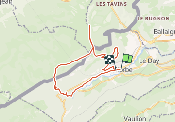
Trail Walking of 15.7 km to be discovered at Vaud, District du Jura-Nord vaudois, Vallorbe. This trail is proposed by vallorbe.

Description

Dès la maison du Reposoir, forte grimpée en forêt, bel abris forestier du Crêt Blanc - route interdite aux voitures qui traversent la frontière - à proximité du Chalet de la Grande Echelle, montez à droite à travers les prairies fleuries.
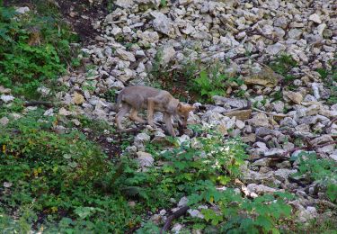
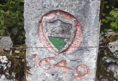
Vous apercevrez peut-être des chamois ou un renard longeant, jusqu''à la cabane de la gym, le mur de pierres sèches qui marque la frontière (remarquez la borne).
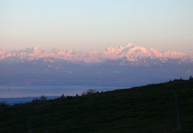
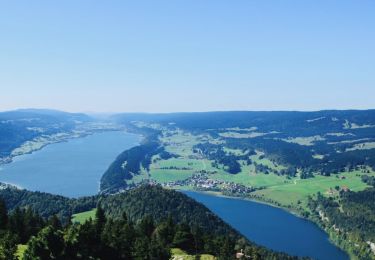
Le sentier au bord de la falaise est à suivre jusqu''au sommet du Mont d''Or. Tout en marchant, admirez le magnifique panorama sur les Alpes, le Suchet, les Aiguilles de Baulmes, Jougne et Métabief.
Retour et traversée de la frontière près de la cabane du CAS de Vallorbe, jusqu''à Pralioux Dessus.Continuez à descendre par la route; peu après l''abri forestier, soit par la route à droite pour la gare, soit par le sentier qui descend directement jusqu''à la piste Vita, puis par la route qui passe au-dessous de la ligne CFF, jusqu''à l''Auberge pour Tous et le centre.

Elevation profile

Points of interest

Point of interest Vallorbe -  - Photo
vallorbe
VALLORBE 
Point of interest Vallorbe - Cabane du Mont d'Or - Photo
vallorbe
Point of interest Jougne - Le Mont d'Or - Photo
vallorbe
JOUGNE 
Point of interest Vallorbe - Grottes de Vallorbe - Photo
vallorbe
Point of interest Longevilles-Mont-d'Or -  - Photo
vallorbe
LONGEVILLES-MONT-D'OR 

Positioning

Country:
Switzerland
Region :
Vaud
Department/Province :
District du Jura-Nord vaudois
Municipality :
Vallorbe
Location:
Unknown
Start:(UTM)
299675 ; 5176494 (32T) N.

Comments

Please log in to post a review or rate the element


Belle balade même si la dernière partie se fait en bord de route. Attention : pas de restauration au Mont d'Or, prévoir le pique-nique.


Trails nearby

Trail Mountain bike Vallorbe - Le Suchet - Photo
Mountain bike
GUIDE+

Mountain bike

Very easy
(1)
Vallorbe, Vaud, District du Jura-Nord vaudois, Switzerland
35 km | 53 km-effort
14h 41min
Yes
Trail On foot Vallorbe - Mont d'Orzeires - Le Pont Gare - Photo
On foot
PRO

On foot

Easy
Vallorbe, Vaud, District du Jura-Nord vaudois, Switzerland
3.2 km | 4.4 km-effort
59min
No
Trail On foot Ballaigues - Ballaigues-Vallorbe - Photo
On foot
PRO

On foot

Easy
Ballaigues, Vaud, District du Jura-Nord vaudois, Switzerland
5.1 km | 6.3 km-effort
1h 25min
No
Trail On foot Vallorbe - Saigne Geret-Les Revines - Photo
On foot
PRO

On foot

Easy
Vallorbe, Vaud, District du Jura-Nord vaudois, Switzerland
3.5 km | 4.1 km-effort
56min
No
Trail On foot Juriens - TP Mollendruz - Romainmôtie - Photo
On foot
PRO

On foot

Easy
Juriens, Vaud, District du Jura-Nord vaudois, Switzerland
7.8 km | 11.6 km-effort
2h 38min
No
Trail Walking L'Abbaye - La Dent de Vaulion - Photo
Walking
drarep

Walking

Very difficult
(1)
L'Abbaye, Vaud, District du Jura-Nord vaudois, Switzerland
14.6 km | 22 km-effort
4h 31min
Yes
Trail Walking Rochejean - Mont d'or  - Photo
Walking
eltonnermou

Walking

Easy
Rochejean, Bourgogne-Franche-Comté, Doubs, France
11.9 km | 17.5 km-effort
4h 53min
Yes
Trail Walking Jougne - La Jougnena - Photo
Walking
daniellebou

Walking

Very difficult
(1)
Jougne, Bourgogne-Franche-Comté, Doubs, France
17.7 km | 24 km-effort
5h 32min
Yes
Trail Snowshoes Longevilles-Mont-d'Or - Les Longevilles Mont D'Or CAF - Photo
Snowshoes
TRIMAILLE

Snowshoes

Medium
(1)
Longevilles-Mont-d'Or, Bourgogne-Franche-Comté, Doubs, France
8.4 km | 13 km-effort
8h 27min
Yes


Close
My subscriptions