Trail Walking Saint-Martin-de-l'If - Les Héberts - Photo

Club Rando Saint-Paër

© OpenStreetMap contributors
Length
Length
8.9 km
Max alt
Max alt
121 m
Uphill gradient
Uphill gradient
172 m
Km-Effort
Km-Effort  
11.2 km
Min alt
Min alt
35 m
Downhill gradient
Downhill gradient
172 m
Boucle
Boucle
Yes
Creation date :
2020-01-20 10:24:37.023
Updated on :
2020-02-14 21:41:08.343

(1 Reviews)

Walking
Walking
2h24
Difficulty : Easy

Scan this QR Code to open this trail in the SityTrail application

FREE GPS app for hiking

Logo SityTrail SityTrail

IGN / Geographical institutes

Download SityTrail from the App Store Download SityTrail from Google Play

Logo SityTrail SityTrail World

The world is yours!

Download SityTrail from the App Store Download SityTrail from Google Play Download SityTrail on Huawei AppGallery

About

Trail Walking of 8.9 km to be discovered at Normandy, Seine-Maritime, Saint-Martin-de-l'If. This trail is proposed by BOUSSOLE ET SAC A DOS.

Description

Randonnée assez facile
Cotation d'effort : 2/5

Elevation profile

Positioning

Country:
France
Region :
Normandy
Department/Province :
Seine-Maritime
Municipality :
Saint-Martin-de-l'If
Location:
Betteville
Start:(UTM)
340344 ; 5491194 (31U) N.

Comments

Please log in to post a review or rate the element


Trails nearby

Trail Walking Rives-en-Seine - saint wandrille 76 - Photo
Walking
nicole.reine@wanadoo.fr

Walking

Medium
Rives-en-Seine, Normandy, Seine-Maritime, France
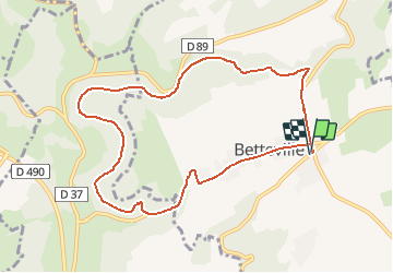
8.7 km | 11.5 km-effort
2h 41min
Yes
Trail Walking Touffreville-la-Corbeline - Touffreville la Corbeline - Photo
Walking
MichelRando7656

Walking

Difficult
(2)
Touffreville-la-Corbeline, Normandy, Seine-Maritime, France
12.4 km | 14.4 km-effort
3h 20min
Yes
Trail Walking Arelaune-en-Seine - Saint-Nicolas de Bliquetuit (Vers l'Armada) - Photo
Walking
MichelRando7656

Walking

Very easy
Arelaune-en-Seine, Normandy, Seine-Maritime, France
11.2 km | 12.2 km-effort
2h 32min
Yes
Trail Mountain bike Rives-en-Seine - Les deux abbayes - Jumièges - Photo
Mountain bike
tracegps

Mountain bike

Medium
Rives-en-Seine, Normandy, Seine-Maritime, France
50 km | 61 km-effort
6h 19min
Yes
Trail Walking Rives-en-Seine - les hauts de caudebecq en caux - Photo
Walking
prv

Walking

Easy
Rives-en-Seine, Normandy, Seine-Maritime, France
10 km | 13.3 km-effort
2h 32min
Yes
Trail Walking Rives-en-Seine - Caudebec en Caux - Photo
Walking
tracegps

Walking

Medium
Rives-en-Seine, Normandy, Seine-Maritime, France
20 km | 26 km-effort
4h 0min
Yes
Trail Walking Rives-en-Seine - St Wandrille le Rançon - Photo
Walking
tracegps

Walking

Medium
Rives-en-Seine, Normandy, Seine-Maritime, France
13.2 km | 16.8 km-effort
2h 40min
Yes
Trail On foot Rives-en-Seine - Saint Wandrille - Bois du Broche Baillif - après-midi - Photo
On foot
lili76520

On foot

Easy
Rives-en-Seine, Normandy, Seine-Maritime, France
11.8 km | 15.1 km-effort
3h 25min
Yes
Trail On foot Rives-en-Seine - Saint Wandrille - Bois de Saint Jacques - Rando matin - Photo
On foot
lili76520

On foot

Easy
Rives-en-Seine, Normandy, Seine-Maritime, France
8 km | 10.6 km-effort
2h 24min
Yes


Close
My subscriptions