Trail Walking Signes - signes1 - Photo
 ghione
ghione

User

© OpenStreetMap contributors
Length
Length
19.5 km
Max alt
Max alt
822 m
Uphill gradient
Uphill gradient
655 m
Km-Effort
Km-Effort  
28 km
Min alt
Min alt
442 m
Downhill gradient
Downhill gradient
661 m
Boucle
Boucle
No
Creation date :
2014-12-10 00:00:00.0
Updated on :
2014-12-10 00:00:00.0

(0 Reviews)

Walking
Walking
5h57
Difficulty : Unknown

Scan this QR Code to open this trail in the SityTrail application

FREE GPS app for hiking

Logo SityTrail SityTrail

IGN / Geographical institutes

Download SityTrail from the App Store Download SityTrail from Google Play

Logo SityTrail SityTrail World

The world is yours!

Download SityTrail from the App Store Download SityTrail from Google Play Download SityTrail on Huawei AppGallery

About

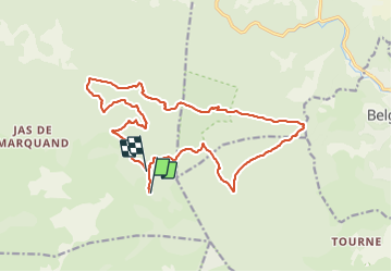
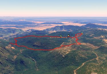
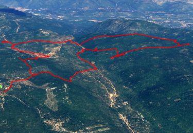
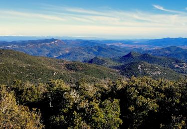
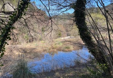
Trail Walking of 19.5 km to be discovered at Provence-Alpes-Côte d'Azur, Var, Signes. This trail is proposed by ghione.

Description

siou blanc,pas de belgentier,les aiguilles de valbelle,le jas de laure,siou blanc

Elevation profile

Positioning

Country:
France
Region :
Provence-Alpes-Côte d'Azur
Department/Province :
Var
Municipality :
Signes
Location:
Unknown
Start:(UTM)
737233 ; 4790199 (31T) N.

Trails nearby

Trail Walking Solliès-Toucas - Morières : la Garoute et la Baume des Lumes - Photo
Walking
GUIDE
affinetataille

Walking

Easy
(1)
Solliès-Toucas, Provence-Alpes-Côte d'Azur, Var, France
12.6 km | 16.7 km-effort
6h 0min
Yes
Trail Walking Solliès-Toucas - SityTrail - siou blanc - Photo
Walking
GUIDE
affinetataille

Walking

Medium
(1)
Solliès-Toucas, Provence-Alpes-Côte d'Azur, Var, France
12.5 km | 17.4 km-effort
6h 0min
Yes
Trail Walking Méounes-lès-Montrieux - SityTrail - montrieux gapeau - Photo
Walking
GUIDE
affinetataille

Walking

Very difficult
(2)
Méounes-lès-Montrieux, Provence-Alpes-Côte d'Azur, Var, France
15.9 km | 23 km-effort
5h 14min
Yes
Trail Walking Méounes-lès-Montrieux - Chartreuse de Montreuil le jeune - Photo
Walking
martinemarie

Walking

Easy
(1)
Méounes-lès-Montrieux, Provence-Alpes-Côte d'Azur, Var, France
11.9 km | 17.1 km-effort
5h 10min
Yes
Trail Walking Le Revest-les-Eaux - Stade du Revest - Turcos - Cassini - Retour  - Photo
Walking
GUIDE
affinetataille

Walking

Medium
Le Revest-les-Eaux, Provence-Alpes-Côte d'Azur, Var, France
11.4 km | 18.2 km-effort
4h 0min
Yes
Trail Walking Solliès-Toucas - Sioux Blanc le cou de la Marquise - Photo
Walking
martinemarie

Walking

Easy
(1)
Solliès-Toucas, Provence-Alpes-Côte d'Azur, Var, France
9.4 km | 12.6 km-effort
5h 5min
Yes
Trail Running Signes - PLATEAU DE SIOUX BLANC - LES AIGUILLES DE VALBELLE - 10KM - Photo
Running
jpb83

Running

Medium
(2)
Signes, Provence-Alpes-Côte d'Azur, Var, France
9.9 km | 13.4 km-effort
1h 45min
Yes
Trail Other activity Signes - Plateau de Siou Blanc 1 - Photo
Other activity
fains-marche

Other activity

Very easy
(1)
Signes, Provence-Alpes-Côte d'Azur, Var, France
3.2 km | 3.8 km-effort
1h 0min
Yes
Trail sport Méounes-lès-Montrieux - LE GAPEAU MP 19.02 V1 - Photo
sport
michelpaulin

sport

Very easy
Méounes-lès-Montrieux, Provence-Alpes-Côte d'Azur, Var, France
14.8 km | 21 km-effort
Unknown
Yes


Close
My subscriptions