Trail On foot Saint-Laurent-de-Terregatte - Barage de Vezins - Vers Saint James - Photo

Barage de Vezins - Vers Saint James

 pierre45
pierre45

User

© OpenStreetMap contributors
Length
Length
15.1 km
Max alt
Max alt
107 m
Uphill gradient
Uphill gradient
390 m
Km-Effort
Km-Effort  
20 km
Min alt
Min alt
29 m
Downhill gradient
Downhill gradient
392 m
Boucle
Boucle
Yes
Creation date :
2020-02-09 18:47:13.155
Updated on :
2020-02-09 18:52:05.318

(0 Reviews)

On foot
On foot
--
Difficulty : Easy

Scan this QR Code to open this trail in the SityTrail application

FREE GPS app for hiking

Logo SityTrail SityTrail

IGN / Geographical institutes

Download SityTrail from the App Store Download SityTrail from Google Play

Logo SityTrail SityTrail World

The world is yours!

Download SityTrail from the App Store Download SityTrail from Google Play Download SityTrail on Huawei AppGallery

About

Trail On foot of 15.1 km to be discovered at Normandy, Manche, Saint-Laurent-de-Terregatte. This trail is proposed by pierre45.

Elevation profile

Positioning

Country:
France
Region :
Normandy
Department/Province :
Manche
Municipality :
Saint-Laurent-de-Terregatte
Location:
Unknown
Start:(UTM)
628995 ; 5384263 (30U) N.

Trails nearby

Trail Walking Ducey-les-Chéris - Au fil de la Sélune - Photo
Walking
tracegps

Walking

Medium
(1)
Ducey-les-Chéris, Normandy, Manche, France
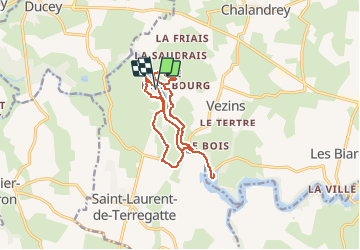
8.6 km | 9.5 km-effort
2h 0min
Yes
Trail Cycle Isigny-le-Buat - Véloscénie 4ème étape - Photo
Cycle
destras

Cycle

Easy
Isigny-le-Buat, Normandy, Manche, France
120 km | 131 km-effort
6h 50min
No
Trail Bicycle tourism Ducey-les-Chéris - Véloscénie Ducey Mont St Michel - Photo
Bicycle tourism
famiski

Bicycle tourism

Very easy
Ducey-les-Chéris, Normandy, Manche, France
33 km | 36 km-effort
2h 51min
No
Trail Mountain bike Ducey-les-Chéris - F.DuceyStMalo37H89.369.VTT0 - Photo
Mountain bike
francois58

Mountain bike

Medium
Ducey-les-Chéris, Normandy, Manche, France
89 km | 96 km-effort
6h 25min
No
Trail Walking Poilley - Courtils - Photo
Walking
Bernardroland

Walking

Very easy
Poilley, Normandy, Manche, France
14.9 km | 15.9 km-effort
3h 46min
No
Trail Walking Ducey-les-Chéris - Ducey - Photo
Walking
PatRando

Walking

Easy
(1)
Ducey-les-Chéris, Normandy, Manche, France
11.5 km | 12.6 km-effort
2h 47min
Yes
Trail Running Saint-Laurent-de-Terregatte - Autour de la Roche qui Boit - Photo
Running
tracegps

Running

Very difficult
Saint-Laurent-de-Terregatte, Normandy, Manche, France
12.4 km | 16.7 km-effort
1h 30min
Yes
Trail Walking Saint-Laurent-de-Terregatte - Autour de la Roche qui Boit - Photo
Walking
tracegps

Walking

Very difficult
Saint-Laurent-de-Terregatte, Normandy, Manche, France
12.4 km | 16.7 km-effort
3h 30min
Yes
Trail Cycle Ducey-les-Chéris - Le Val de l'Oir - Photo
Cycle
tracegps

Cycle

Medium
Ducey-les-Chéris, Normandy, Manche, France
28 km | 35 km-effort
2h 0min
No


Close
My subscriptions