Trail Walking Euvezin - Haut d'Euvezin Chapelle de Remenauville - Photo

Haut d'Euvezin Chapelle de Remenauville

 kikkko
kikkko

User

© OpenStreetMap contributors
Length
Length
10.9 km
Max alt
Max alt
336 m
Uphill gradient
Uphill gradient
138 m
Km-Effort
Km-Effort  
12.7 km
Min alt
Min alt
260 m
Downhill gradient
Downhill gradient
135 m
Boucle
Boucle
No
Creation date :
2020-02-19 13:07:34.093
Updated on :
2020-02-19 16:25:18.645

(0 Reviews)

Walking
Walking
2h33
Difficulty : Medium

Scan this QR Code to open this trail in the SityTrail application

FREE GPS app for hiking

Logo SityTrail SityTrail

IGN / Geographical institutes

Download SityTrail from the App Store Download SityTrail from Google Play

Logo SityTrail SityTrail World

The world is yours!

Download SityTrail from the App Store Download SityTrail from Google Play Download SityTrail on Huawei AppGallery

About

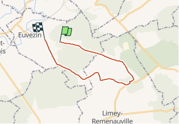
Trail Walking of 10.9 km to be discovered at Grand Est, Meurthe-et-Moselle, Euvezin. This trail is proposed by kikkko.

Description

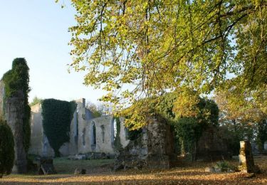
Circuit entre forêt et plaine avec découverte du village détruit de Remenauville

Elevation profile

Positioning

Country:
France
Region :
Grand Est
Department/Province :
Meurthe-et-Moselle
Municipality :
Euvezin
Location:
Unknown
Start:(UTM)
709460 ; 5422596 (31U) N.

Trails nearby

Trail Cycle Thiaucourt-Regniéville - Les paysages de l'Histoire (option Flirey) - Circuit n° 13 - Photo
Cycle
tracegps

Cycle

Difficult
Thiaucourt-Regniéville, Grand Est, Meurthe-et-Moselle, France
60 km | 68 km-effort
3h 0min
Yes
Trail Cycle Thiaucourt-Regniéville - Les paysages de l'Histoire - Circuit n° 13 - Thiaucourt Regniéville - Photo
Cycle
tracegps

Cycle

Medium
Thiaucourt-Regniéville, Grand Est, Meurthe-et-Moselle, France
49 km | 56 km-effort
2h 30min
Yes
Trail Mountain bike Thiaucourt-Regniéville - Thiaucourt Jaulny Rembercourt - Photo
Mountain bike
kikkko

Mountain bike

Easy
Thiaucourt-Regniéville, Grand Est, Meurthe-et-Moselle, France
16.9 km | 21 km-effort
1h 36min
Yes
Trail Walking Euvezin - Euvezin Bouillonville Thiaucourt et retour par les hauts - Photo
Walking
kikkko

Walking

Medium
Euvezin, Grand Est, Meurthe-et-Moselle, France
10.9 km | 13.5 km-effort
3h 4min
Yes
Trail Walking Viéville-en-Haye - circuit des Rappes - Photo
Walking
kikkko

Walking

Easy
Viéville-en-Haye, Grand Est, Meurthe-et-Moselle, France
13.6 km | 16.2 km-effort
2h 33min
No
Trail Horseback riding Pannes - Madine - Photo
Horseback riding
jcvmax

Horseback riding

Very difficult
Pannes, Grand Est, Meurthe-et-Moselle, France
38 km | 47 km-effort
8h 7min
No
Trail Mountain bike Thiaucourt-Regniéville - sortie de thaucourd ctm - Photo
Mountain bike
nouga

Mountain bike

Difficult
Thiaucourt-Regniéville, Grand Est, Meurthe-et-Moselle, France
26 km | 31 km-effort
2h 30min
Yes
Trail Walking Thiaucourt-Regniéville - Thiaucourt Bouillonville - Photo
Walking
kikkko

Walking

Easy
Thiaucourt-Regniéville, Grand Est, Meurthe-et-Moselle, France
9.7 km | 11.7 km-effort
2h 23min
Yes
Trail Mountain bike Thiaucourt-Regniéville - EC CTM THIAUCOURT 1 - Photo
Mountain bike
PascalKvtt

Mountain bike

Easy
Thiaucourt-Regniéville, Grand Est, Meurthe-et-Moselle, France
16.9 km | 21 km-effort
1h 22min
No


Close
My subscriptions