Trail Nordic walking Wissant - la Baie de Canche - Photo
© OpenStreetMap contributors
Length
Length
10.8 km
Max alt
Max alt
161 m
Uphill gradient
Uphill gradient
168 m
Km-Effort
Km-Effort  
13.1 km
Min alt
Min alt
15 m
Downhill gradient
Downhill gradient
168 m
Boucle
Boucle
No
Creation date :
2020-02-24 21:07:23.09
Updated on :
2020-02-24 21:12:34.867

(0 Reviews)

Nordic walking
Nordic walking
2h48
Difficulty : Medium

Scan this QR Code to open this trail in the SityTrail application

FREE GPS app for hiking

Logo SityTrail SityTrail

IGN / Geographical institutes

Download SityTrail from the App Store Download SityTrail from Google Play

Logo SityTrail SityTrail World

The world is yours!

Download SityTrail from the App Store Download SityTrail from Google Play Download SityTrail on Huawei AppGallery

About

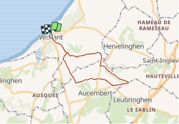
Trail Nordic walking of 10.8 km to be discovered at Hauts-de-France, Pas-de-Calais, Wissant. This trail is proposed by denissculier.

Description

POINT DE DEPART : CENTRE DE THALASSO - LE TOUQUET

Un itinéraire aux multiples facettes puisque les paysages alternent entre grande plage de sable fin, dunes boisées, mollières (prés salés) abritant les huttes des chasseurs de gibiers d’eau et l’architecture balnéaire de la station du Touquet.
La baie de Canche, point de rencontre entre l’estuaire du fleuve et les dunes offre plus de 500 hectares de réserve naturelle, ce milieu compte une multitude d’espèces végétales et ornithologiques.

Elevation profile

Positioning

Country:
France
Region :
Hauts-de-France
Department/Province :
Pas-de-Calais
Municipality :
Wissant
Location:
Unknown
Start:(Dec)
Start:(UTM)
405946 ; 5637924 (31U) N.

Trails nearby

Trail Walking Wissant - Wissant-Mont de Couple- retour par la plage - Photo
Walking
Vagabond gaumardennais

Walking

Difficult
(1)
Wissant, Hauts-de-France, Pas-de-Calais, France
14.3 km | 0 m-effort
2h 53min
Yes
Trail Walking Wissant - Le Fartz - Photo
Walking
terminio

Walking

Very easy
(1)
Wissant, Hauts-de-France, Pas-de-Calais, France
5.5 km | 6.2 km-effort
1h 29min
Yes
Trail Walking Escalles - Les balcons d'Escalles  - Photo
Walking
tracegps

Walking

Medium
(4)
Escalles, Hauts-de-France, Pas-de-Calais, France
7.8 km | 10.5 km-effort
2h 0min
Yes
Trail Walking Sangatte - Le Site des 2 Caps - Les Falaises du Cap Blanc Nez et le Mont d'Hubert - Photo
Walking
tracegps

Walking

Medium
(3)
Sangatte, Hauts-de-France, Pas-de-Calais, France
11.2 km | 14.7 km-effort
3h 0min
Yes
Trail Walking Tardinghen - Le Site des 2 Caps - Le Sentier des Crans - Photo
Walking
tracegps

Walking

Medium
(2)
Tardinghen, Hauts-de-France, Pas-de-Calais, France
12 km | 14.3 km-effort
3h 0min
Yes
Trail Walking Tardinghen - Sentier du Fartz - Waissant - Photo
Walking
tracegps

Walking

Easy
(1)
Tardinghen, Hauts-de-France, Pas-de-Calais, France
5.1 km | 5.8 km-effort
1h 30min
Yes
Trail Walking Tardinghen - Le Site des 2 Caps - Le Sentier des Crans - Photo
Walking
GUIDE
Desrumaux

Walking

Easy
(3)
Tardinghen, Hauts-de-France, Pas-de-Calais, France
12 km | 14.3 km-effort
3h 0min
Yes
Trail Walking Wissant - Le Site des 2 Caps - Le Sentier du Phartz et de la Dune d'Aval - Photo
Walking
GUIDE
Desrumaux

Walking

Easy
(3)
Wissant, Hauts-de-France, Pas-de-Calais, France
7.4 km | 8.3 km-effort
1h 50min
Yes
Trail Walking Sangatte - Le Site des 2 Caps - Les Falaises du Cap Blanc Nez et le Mont d'Hubert - Photo
Walking
GUIDE
Desrumaux

Walking

Easy
(4)
Sangatte, Hauts-de-France, Pas-de-Calais, France
11.2 km | 14.7 km-effort
2h 50min
Yes


Close
My subscriptions