Trail Walking Maurepas - marche du 12 mars 2020 - Photo

marche du 12 mars 2020

 jimch58
jimch58

User

© OpenStreetMap contributors
Length
Length
7 km
Max alt
Max alt
178 m
Uphill gradient
Uphill gradient
36 m
Km-Effort
Km-Effort  
7.5 km
Min alt
Min alt
168 m
Downhill gradient
Downhill gradient
36 m
Boucle
Boucle
No
Creation date :
2020-03-12 07:44:08.366
Updated on :
2020-03-12 11:18:12.674

(0 Reviews)

Walking
Walking
1h46
Difficulty : Very easy

Scan this QR Code to open this trail in the SityTrail application

FREE GPS app for hiking

Logo SityTrail SityTrail

IGN / Geographical institutes

Download SityTrail from the App Store Download SityTrail from Google Play

Logo SityTrail SityTrail World

The world is yours!

Download SityTrail from the App Store Download SityTrail from Google Play Download SityTrail on Huawei AppGallery

About

Trail Walking of 7 km to be discovered at Ile-de-France, Yvelines, Maurepas. This trail is proposed by jimch58.

Description

lire 6,4km au point de retour (ensuite retour maison en auto, gps toujours actif).

Elevation profile

Positioning

Country:
France
Region :
Ile-de-France
Department/Province :
Yvelines
Municipality :
Maurepas
Location:
Unknown
Start:(UTM)
421609 ; 5401874 (31U) N.

Trails nearby

Trail Walking Lévis-Saint-Nom - _Le Vallon du Pommeret - Photo
Walking
GUIDE+

Walking

Easy
(11)
Lévis-Saint-Nom, Ile-de-France, Yvelines, France
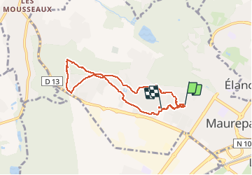
6.3 km | 8 km-effort
1h 30min
Yes
Trail Walking Le Mesnil-Saint-Denis - _Entre ancienne châtellenie et Ville nouvelle - Photo
Walking
GUIDE+

Walking

Easy
(1)
Le Mesnil-Saint-Denis, Ile-de-France, Yvelines, France
8.6 km | 9.5 km-effort
2h 30min
Yes
Trail Walking Lévis-Saint-Nom - _L'Yvette - Photo
Walking
GUIDE+

Walking

Easy
(4)
Lévis-Saint-Nom, Ile-de-France, Yvelines, France
5.2 km | 7 km-effort
1h 29min
Yes
Trail Walking Le Tremblay-sur-Mauldre - rando du 12/03/2015 - Photo
Walking
microb

Walking

Easy
(1)
Le Tremblay-sur-Mauldre, Ile-de-France, Yvelines, France
7.1 km | 9.3 km-effort
1h 59min
Yes
Trail Walking Lévis-Saint-Nom - _Girouard - Photo
Walking
GUIDE+

Walking

Medium
(1)
Lévis-Saint-Nom, Ile-de-France, Yvelines, France
8 km | 10 km-effort
2h 0min
Yes
Trail On foot Le Mesnil-Saint-Denis - Liaison douce le Mesnil - Cheuvreuse - Photo
On foot
PRO

On foot

Easy
Le Mesnil-Saint-Denis, Ile-de-France, Yvelines, France
9.1 km | 10.4 km-effort
2h 22min
No
Trail Mountain bike Élancourt - VTT elancourt - Photo
Mountain bike
GUIDE
affinetataille

Mountain bike

Easy
Élancourt, Ile-de-France, Yvelines, France
26 km | 29 km-effort
2h 1min
Yes
Trail Walking Le Mesnil-Saint-Denis - Noé et fort Manoir - Photo
Walking
huguesb

Walking

Easy
Le Mesnil-Saint-Denis, Ile-de-France, Yvelines, France
8.4 km | 9.4 km-effort
2h 1min
No
Trail Walking Maurepas - 10852243-ADAL_MAUREPAS_14012020 - Photo
Walking
VVerley

Walking

Difficult
(1)
Maurepas, Ile-de-France, Yvelines, France
17.8 km | 22 km-effort
4h 49min
Yes


Close
My subscriptions