Trail Walking Bouleurs - SityTrail - Bouleurs - Photo
 vitius
vitius

User

© OpenStreetMap contributors
Length
Length
16.6 km
Max alt
Max alt
166 m
Uphill gradient
Uphill gradient
203 m
Km-Effort
Km-Effort  
19.3 km
Min alt
Min alt
88 m
Downhill gradient
Downhill gradient
203 m
Boucle
Boucle
Yes
Creation date :
2020-03-12 15:13:27.529
Updated on :
2024-03-12 09:42:49.493

(1 Reviews)

Walking
Walking
4h22
Difficulty : Very difficult

Scan this QR Code to open this trail in the SityTrail application

FREE GPS app for hiking

Logo SityTrail SityTrail

IGN / Geographical institutes

Download SityTrail from the App Store Download SityTrail from Google Play

Logo SityTrail SityTrail World

The world is yours!

Download SityTrail from the App Store Download SityTrail from Google Play Download SityTrail on Huawei AppGallery

About

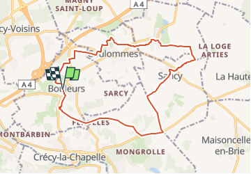
Trail Walking of 16.6 km to be discovered at Ile-de-France, Seine-et-Marne, Bouleurs. This trail is proposed by vitius.

Description

11 Octobre 2015

Elevation profile

Positioning

Country:
France
Region :
Ile-de-France
Department/Province :
Seine-et-Marne
Municipality :
Bouleurs
Location:
Unknown
Start:(UTM)
493067 ; 5414100 (31U) N.

Comments

Please log in to post a review or rate the element


Trails nearby

Trail Walking Crécy-la-Chapelle - Crécy la Chapelle Parcours normal - Photo
Walking
CC.RIDER

Walking

Easy
(1)
Crécy-la-Chapelle, Ile-de-France, Seine-et-Marne, France
16.1 km | 19.5 km-effort
4h 18min
Yes
Trail Walking Crécy-la-Chapelle - Crécy la chapelle - Photo
Walking
CC.RIDER

Walking

Easy
(2)
Crécy-la-Chapelle, Ile-de-France, Seine-et-Marne, France
19.7 km | 24 km-effort
5h 12min
Yes
Trail Walking Crécy-la-Chapelle - Crécy la Chapelle - Photo
Walking
jctinchebray

Walking

Medium
(1)
Crécy-la-Chapelle, Ile-de-France, Seine-et-Marne, France
16.4 km | 20 km-effort
4h 23min
Yes
Trail Walking Crécy-la-Chapelle - Autour de Tigeaux - Photo
Walking
em77

Walking

Medium
(2)
Crécy-la-Chapelle, Ile-de-France, Seine-et-Marne, France
13.2 km | 16.5 km-effort
2h 37min
Yes
Trail Walking Crécy-la-Chapelle - Boucle 28 km autour de Crecy la Chapelle - Guérard - Voulangis - Tigeaux - Photo
Walking
chessyca

Walking

Medium
Crécy-la-Chapelle, Ile-de-France, Seine-et-Marne, France
28 km | 35 km-effort
5h 46min
Yes
Trail Walking Crécy-la-Chapelle - Les coteaux du Grand Morin - Photo
Walking
Bntg

Walking

Medium
Crécy-la-Chapelle, Ile-de-France, Seine-et-Marne, France
11.8 km | 14.3 km-effort
3h 6min
Yes
Trail Walking Bouleurs - Bouleurs - Photo
Walking
PatRando

Walking

Easy
Bouleurs, Ile-de-France, Seine-et-Marne, France
16.4 km | 18.6 km-effort
4h 5min
Yes
Trail Cycle Saint-Germain-sur-Morin - Le nord de la Vallée du grand Morin - Photo
Cycle
destras

Cycle

Medium
Saint-Germain-sur-Morin, Ile-de-France, Seine-et-Marne, France
53 km | 63 km-effort
3h 10min
Yes
Trail Running Condé-Sainte-Libiaire - Condé - Photo
Running
32mike32

Running

Very easy
(2)
Condé-Sainte-Libiaire, Ile-de-France, Seine-et-Marne, France
11.8 km | 14.1 km-effort
1h 10min
Yes


Close
My subscriptions