Trail Walking Saint-Appolinard - st appollinard - Photo
 bpc
bpc

User

© OpenStreetMap contributors
Length
Length
7.8 km
Max alt
Max alt
835 m
Uphill gradient
Uphill gradient
360 m
Km-Effort
Km-Effort  
12.7 km
Min alt
Min alt
471 m
Downhill gradient
Downhill gradient
368 m
Boucle
Boucle
Yes
Creation date :
2014-12-10 00:00:00.0
Updated on :
2014-12-10 00:00:00.0

(1 Reviews)

Walking
Walking
2h30
Difficulty : Medium

Scan this QR Code to open this trail in the SityTrail application

FREE GPS app for hiking

Logo SityTrail SityTrail

IGN / Geographical institutes

Download SityTrail from the App Store Download SityTrail from Google Play

Logo SityTrail SityTrail World

The world is yours!

Download SityTrail from the App Store Download SityTrail from Google Play Download SityTrail on Huawei AppGallery

About

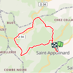
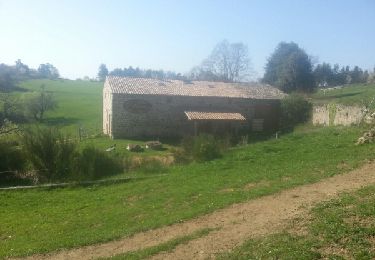
Trail Walking of 7.8 km to be discovered at Auvergne-Rhône-Alpes, Loire, Saint-Appolinard. This trail is proposed by bpc.

Description

montée sur sainte blandine

Elevation profile

Photos

Positioning

Country:
France
Region :
Auvergne-Rhône-Alpes
Department/Province :
Loire
Municipality :
Saint-Appolinard
Location:
Unknown
Start:(UTM)
629390 ; 5022294 (31T) N.

Comments

Please log in to post a review or rate the element


Trails nearby

Trail On foot Maclas - Maclas - 11,1 km - 227 m de dénivelé - 3h30 - Photo
On foot
Clubléorando

On foot

Medium
(1)
Maclas, Auvergne-Rhône-Alpes, Loire, France
11.1 km | 14.1 km-effort
3h 30min
Yes
Trail sport Brossainc - Brossainc lac du Ternay  - Photo
sport
alinetpierre

sport

Very easy
Brossainc, Auvergne-Rhône-Alpes, Ardèche, France
18 km | 25 km-effort
Unknown
Yes
Trail Walking Roisey - Le cret de l'oeillon - Photo
Walking
Vedett26

Walking

Difficult
(1)
Roisey, Auvergne-Rhône-Alpes, Loire, France
13.3 km | 22 km-effort
4h 59min
Yes
Trail Walking Colombier - 42-st-sabin-pilat-18km-610m-juil21 - Photo
Walking
SyMA

Walking

Medium
Colombier, Auvergne-Rhône-Alpes, Loire, France
18.9 km | 27 km-effort
5h 19min
Yes
Trail Walking Colombier - 42-st-sabin-cret-de-perdrix-16km-620m - Photo
Walking
SyMA

Walking

Medium
Colombier, Auvergne-Rhône-Alpes, Loire, France
16 km | 24 km-effort
3h 57min
Yes
Trail Walking Savas - 07 Lac du ternay / croix des Blaches 8km 230M - Photo
Walking
SyMA

Walking

Very easy
(1)
Savas, Auvergne-Rhône-Alpes, Ardèche, France
8 km | 11 km-effort
2h 20min
Yes
Trail Walking Véranne - pilat-TDF-saint sabin - Photo
Walking
m261212

Walking

Medium
(1)
Véranne, Auvergne-Rhône-Alpes, Loire, France
17.9 km | 26 km-effort
5h 20min
Yes
Trail Mountain bike Bessey - Autour de Pélussin - Photo
Mountain bike
tracegps

Mountain bike

Difficult
Bessey, Auvergne-Rhône-Alpes, Loire, France
29 km | 38 km-effort
3h 0min
Yes
Trail Walking Saint-Appolinard - St Appolinard St Blandine - Photo
Walking
novop

Walking

Easy
Saint-Appolinard, Auvergne-Rhône-Alpes, Loire, France
6.7 km | 10.7 km-effort
1h 17min
Yes


Close
My subscriptions