Trail Bicycle tourism Sassenage - retour maison - Photo
© OpenStreetMap contributors
Length
Length
3.2 km
Max alt
Max alt
217 m
Uphill gradient
Uphill gradient
28 m
Km-Effort
Km-Effort  
3.5 km
Min alt
Min alt
199 m
Downhill gradient
Downhill gradient
27 m
Boucle
Boucle
No
Creation date :
2020-03-25 18:31:57.192
Updated on :
2020-03-25 19:13:25.75

(0 Reviews)

Bicycle tourism
Bicycle tourism
15m
Difficulty : Very easy
Canoe - kayak
Canoe - kayak
25m
Difficulty : Very easy

Scan this QR Code to open this trail in the SityTrail application

FREE GPS app for hiking

Logo SityTrail SityTrail

IGN / Geographical institutes

Download SityTrail from the App Store Download SityTrail from Google Play

Logo SityTrail SityTrail World

The world is yours!

Download SityTrail from the App Store Download SityTrail from Google Play Download SityTrail on Huawei AppGallery

About

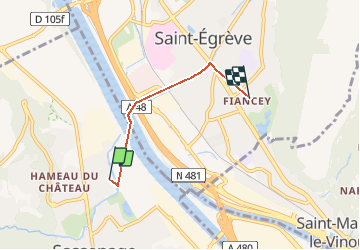
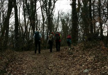
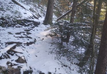
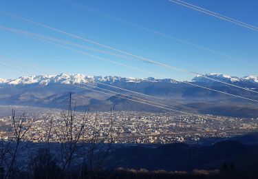
Trail Bicycle tourism of 3.2 km to be discovered at Auvergne-Rhône-Alpes, Isère, Sassenage. This trail is proposed by Jean-Christophe Rolland.

Elevation profile

Positioning

Country:
France
Region :
Auvergne-Rhône-Alpes
Department/Province :
Isère
Municipality :
Sassenage
Location:
Unknown
Start:(UTM)
709318 ; 5010321 (31T) N.

Trails nearby

Trail Walking Sassenage - La ferme Durand - Photo
Walking
crocau

Walking

Easy
(1)
Sassenage, Auvergne-Rhône-Alpes, Isère, France
6.2 km | 13.3 km-effort
2h 7min
Yes
Trail Nordic walking Sassenage - Parc de l'Ovalie - Noyarey - Photo
Nordic walking
patjobou

Nordic walking

Easy
(1)
Sassenage, Auvergne-Rhône-Alpes, Isère, France
11.8 km | 13 km-effort
2h 20min
No
Trail Walking Engins - Circuit pas de la Lose, du Tracollet, de l'Ours avec un retour par le passage  de la Grande Combe - Photo
Walking
Emelle

Walking

Medium
(3)
Engins, Auvergne-Rhône-Alpes, Isère, France
10.9 km | 21 km-effort
5h 12min
Yes
Trail Walking Fontaine - M le 20 cabane de Laura - Photo
Walking
Ninie38MD

Walking

Difficult
(1)
Fontaine, Auvergne-Rhône-Alpes, Isère, France
16.8 km | 30 km-effort
6h 59min
Yes
Trail Walking Saint-Nizier-du-Moucherotte - GTV - Tour du Vercors à pied - Saint Nizier du Moucherotte - Les Cochettes  - Photo
Walking
tracegps

Walking

Difficult
(1)
Saint-Nizier-du-Moucherotte, Auvergne-Rhône-Alpes, Isère, France
23 km | 42 km-effort
6h 45min
No
Trail Mountain bike Grenoble - Grande Traversée des PréAlpes à VTT : Grenoble - Sisteron - Digne les Bains - Photo
Mountain bike
tracegps

Mountain bike

Very difficult
(2)
Grenoble, Auvergne-Rhône-Alpes, Isère, France
375 km | 539 km-effort
48h 0min
No
Trail Walking Proveysieux - le rocher de l'Eglise en traversee - Photo
Walking
cmarit

Walking

Difficult
(1)
Proveysieux, Auvergne-Rhône-Alpes, Isère, France
10.5 km | 22 km-effort
8h 16min
Yes
Trail Walking Fontaine - Coup de Sabre - Moucherotte - Ferme Durand - Parc Karl Marx - Photo
Walking
Luc Saint-guillain

Walking

Very difficult
Fontaine, Auvergne-Rhône-Alpes, Isère, France
28 km | 52 km-effort
7h 8min
Yes
Trail Walking Seyssinet-Pariset - Sous la Ferme Charvet - Photo
Walking
patjobou

Walking

Easy
Seyssinet-Pariset, Auvergne-Rhône-Alpes, Isère, France
3.1 km | 4.5 km-effort
1h 1min
Yes


Close
My subscriptions