Trail Walking Beure - planoise groupe - Photo
© OpenStreetMap contributors
Length
Length
19.8 km
Max alt
Max alt
504 m
Uphill gradient
Uphill gradient
624 m
Km-Effort
Km-Effort  
28 km
Min alt
Min alt
231 m
Downhill gradient
Downhill gradient
621 m
Boucle
Boucle
Yes
Creation date :
2020-05-25 06:51:42.577
Updated on :
2020-05-26 18:35:31.677

(0 Reviews)

Walking
Walking
6h03
Difficulty : Medium

Scan this QR Code to open this trail in the SityTrail application

FREE GPS app for hiking

Logo SityTrail SityTrail

IGN / Geographical institutes

Download SityTrail from the App Store Download SityTrail from Google Play

Logo SityTrail SityTrail World

The world is yours!

Download SityTrail from the App Store Download SityTrail from Google Play Download SityTrail on Huawei AppGallery

About

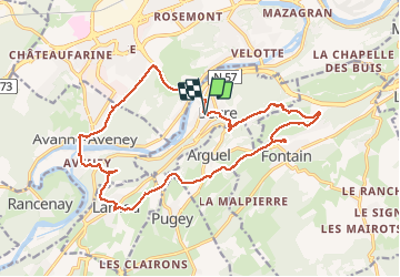
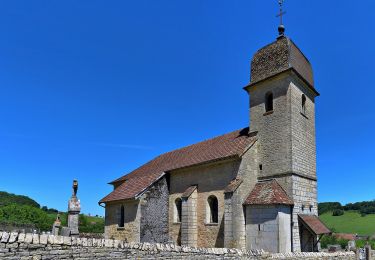
Trail Walking of 19.8 km to be discovered at Bourgogne-Franche-Comté, Doubs, Beure. This trail is proposed by eltonnermou.

Description

Attention, avec le petit problème d'enregistrement du début de rando, la distance réelle est de 18,5 ! Pour les plus courageux : en fin de parcours vous pouvez passer par la cascade de la pisseur (détour de 500m maxi).
Belle randonnée pour une reprise. Ce  parcours pédestre vous entrainera au fort de Planoise (à visiter si ce n'est pas déjà fait) puis au rocher de Valmy. Profitez des nombreux points de vue tout au long du parcours en sous bois et sur le parcours des crêtes.   Avec un peu de chance, vous surprendrez des chamois sur les pentes escarpées du secteur. Vous pourrez apprécier la diversité de la flore. Le long du ruisseau "les mercureaux" (les écrevisses ont-elles disparues ? mais d'autres animaux méritent aussi l'observation). Admirer les  cascades lors de la descente vers votre parking.

Elevation profile

Photos

Positioning

Country:
France
Region :
Bourgogne-Franche-Comté
Department/Province :
Doubs
Municipality :
Beure
Location:
Unknown
Start:(UTM)
272881 ; 5232525 (32T) N.

Trails nearby

Trail Walking Serre-les-Sapins - serre les sapins la ménère - Photo
Walking
eltonnermou

Walking

Very easy
(1)
Serre-les-Sapins, Bourgogne-Franche-Comté, Doubs, France
10.4 km | 12.6 km-effort
1h 48min
Yes
Trail Walking Beure -
Walking
eltonnermou

Walking

Medium
(1)
Beure, Bourgogne-Franche-Comté, Doubs, France
15.7 km | 22 km-effort
6h 35min
Yes
Trail Walking Besançon - Colline de Besançon 29-08-2020 - Photo
Walking
legios84

Walking

Medium
(1)
Besançon, Bourgogne-Franche-Comté, Doubs, France
13.4 km | 17.7 km-effort
2h 46min
Yes
Trail On foot Busy - Sentier de la Pierre de Vorges - Photo
On foot
PRO

On foot

Easy
Busy, Bourgogne-Franche-Comté, Doubs, France
7.2 km | 9.4 km-effort
2h 8min
Yes
Trail On foot Fontain - Grande Boucle de Fontain - Photo
On foot
PRO

On foot

Easy
Fontain, Bourgogne-Franche-Comté, Doubs, France
10 km | 13.2 km-effort
2h 59min
Yes
Trail On foot Morre - Sentier des Buis - Photo
On foot
PRO

On foot

Easy
Morre, Bourgogne-Franche-Comté, Doubs, France
6.4 km | 9 km-effort
2h 2min
Yes
Trail On foot Fontain - Sentier des Grands Prés - Photo
On foot
PRO

On foot

Easy
Fontain, Bourgogne-Franche-Comté, Doubs, France
6.6 km | 9.6 km-effort
2h 10min
Yes
Trail On foot Besançon - Circuit de Planoise - Photo
On foot
PRO

On foot

Easy
Besançon, Bourgogne-Franche-Comté, Doubs, France
4.6 km | 7.6 km-effort
1h 43min
Yes
Trail On foot Besançon - Circuit du Fort de Chaudanne - Photo
On foot
PRO

On foot

Easy
Besançon, Bourgogne-Franche-Comté, Doubs, France
6 km | 8.7 km-effort
1h 59min
Yes


Close
My subscriptions