Trail Walking Versailles - Versailles - Mantes 2014 - Photo

Versailles - Mantes 2014

 Tonyar
Tonyar

User

© OpenStreetMap contributors
Length
Length
52 km
Max alt
Max alt
192 m
Uphill gradient
Uphill gradient
523 m
Km-Effort
Km-Effort  
60 km
Min alt
Min alt
16 m
Downhill gradient
Downhill gradient
616 m
Boucle
Boucle
No
Creation date :
2014-12-10 00:00:00.0
Updated on :
2014-12-10 00:00:00.0

(0 Reviews)

Walking
Walking
8h15
Difficulty : Difficult

Scan this QR Code to open this trail in the SityTrail application

FREE GPS app for hiking

Logo SityTrail SityTrail

IGN / Geographical institutes

Download SityTrail from the App Store Download SityTrail from Google Play

Logo SityTrail SityTrail World

The world is yours!

Download SityTrail from the App Store Download SityTrail from Google Play Download SityTrail on Huawei AppGallery

About

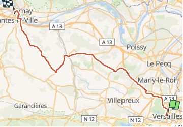
Trail Walking of 52 km to be discovered at Ile-de-France, Yvelines, Versailles. This trail is proposed by Tonyar.

Description

Deuxième participation au Paris - Versailles.
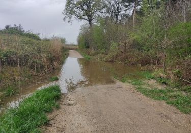
Nouveau parcours, moins difficile qu'en 2013, plus de boue, un peu dommage !!
Nouveau parcours un peu moins long (2 km de moins), du coup 1 heure de moins qu'en 2013 (8h15 au lieu de 9h30).
Dommage qu'au départ on évite le parc du château. A l'année prochaine

Elevation profile

Positioning

Country:
France
Region :
Ile-de-France
Department/Province :
Yvelines
Municipality :
Versailles
Location:
Unknown
Start:(UTM)
435854 ; 5406100 (31U) N.

Trails nearby

Trail Walking Viroflay - Les 3 Forêts; Meudon, Fausses Reposes et Versailles - Photo
Walking
tracegps

Walking

Difficult
(2)
Viroflay, Ile-de-France, Yvelines, France
25 km | 32 km-effort
5h 19min
Yes
Trail Walking Chaville - Sentier des deux Forêts - Meudon et Verrières - Photo
Walking
tracegps

Walking

Difficult
(2)
Chaville, Ile-de-France, Hauts-de-Seine, France
23 km | 29 km-effort
5h 0min
Yes
Trail Walking Buc - Le Tour de Satory - Photo
Walking
tracegps

Walking

Difficult
(2)
Buc, Ile-de-France, Yvelines, France
23 km | 28 km-effort
4h 49min
Yes
Trail Walking Guyancourt - ALBG Etang val d'or, minière - Photo
Walking
IreneProvost

Walking

Easy
(1)
Guyancourt, Ile-de-France, Yvelines, France
13.1 km | 16.1 km-effort
3h 41min
Yes
Trail Other activity Versailles - Parc de Versailles - Photo
Other activity
irokoitennis

Other activity

Very easy
(1)
Versailles, Ile-de-France, Yvelines, France
8.9 km | 9.7 km-effort
1h 49min
Yes
Trail Mountain bike Saint-Cyr-l'École - 14102013 - Photo
Mountain bike
jcvolpe

Mountain bike

Medium
(1)
Saint-Cyr-l'École, Ile-de-France, Yvelines, France
42 km | 50 km-effort
3h 11min
Yes
Trail Mountain bike Chaville - grand circuit VTT - Photo
Mountain bike
macleon

Mountain bike

Very easy
(1)
Chaville, Ile-de-France, Hauts-de-Seine, France
32 km | 40 km-effort
Unknown
Yes
Trail Walking Vélizy-Villacoublay - Les forêts de Meudon et Versailles  - Photo
Walking
c.chehere

Walking

Easy
Vélizy-Villacoublay, Ile-de-France, Yvelines, France
14.5 km | 17.2 km-effort
3h 50min
Yes
Trail Walking Vaucresson - GRP CV-IDF 2023 - Photo
Walking
clalaur

Walking

Easy
Vaucresson, Ile-de-France, Hauts-de-Seine, France
11.9 km | 15.3 km-effort
3h 29min
No


Close
My subscriptions