Trail Walking Gex - GEX - COL DE LA FAUCILLE    - Photo

GEX - COL DE LA FAUCILLE

 otgex
otgex

User

© OpenStreetMap contributors
Length
Length
7.4 km
Max alt
Max alt
1347 m
Uphill gradient
Uphill gradient
738 m
Km-Effort
Km-Effort  
14.8 km
Min alt
Min alt
600 m
Downhill gradient
Downhill gradient
9 m
Boucle
Boucle
No
Creation date :
2014-12-11 00:00:00.0
Updated on :
2014-12-11 00:00:00.0

(0 Reviews)

Walking
Walking
3h46
Difficulty : Unknown

Scan this QR Code to open this trail in the SityTrail application

FREE GPS app for hiking

Logo SityTrail SityTrail

IGN / Geographical institutes

Download SityTrail from the App Store Download SityTrail from Google Play

Logo SityTrail SityTrail World

The world is yours!

Download SityTrail from the App Store Download SityTrail from Google Play Download SityTrail on Huawei AppGallery

About

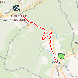
Trail Walking of 7.4 km to be discovered at Auvergne-Rhône-Alpes, Ain, Gex. This trail is proposed by otgex.

Description

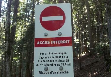
Depuis l''Office de Tourisme de Gex, rejoindre la mairie, puis prendre la rue Charles Harent (forte pente), qui rejoint la place Perdtemps, de là, suivre la D1005 sur 100 m, puis la traverser pour  prendre la Route de Rogeland. La monter en totalité. Arrivée au stop, carrefour fontaine, prendre tout droit, face au Jura. A la 2ème jonction de la RD1005, traverser la route pour prendre le chemin qui part en fôret (bouche d''égouts). Au carrefour suivant, prendre  à gauche (sens montée), et poursuivre la route , arrivée à hauteur de Florimont, restez toujours sur le sentier. A la jonction de la RD1005, prendre sur la gauche (sens montée), le sentier qui coupe le virage de la Fontaine Napoléon.  évoluez derrière les glissières de sécurité. Recouper la RD1005 pour prendre le sentier qui part sur la droite.

Elevation profile

Positioning

Country:
France
Region :
Auvergne-Rhône-Alpes
Department/Province :
Ain
Municipality :
Gex
Location:
Unknown
Start:(UTM)
273690 ; 5135163 (32T) N.

Trails nearby

Trail Running Mijoux - UTTJ 2015-2 - Photo
Running
bourel.jacques

Running

Very difficult
(1)
Mijoux, Auvergne-Rhône-Alpes, Ain, France
57 km | 92 km-effort
18h 13min
No
Trail Walking Gex - Balade à Col de la Faucille, Gex - Photo
Walking
Gaiato

Walking

Very difficult
Gex, Auvergne-Rhône-Alpes, Ain, France
86 km | 135 km-effort
9h 23min
No
Trail Bicycle tourism Mijoux - LES ROUSSES - COL DE LA FAUCILLE  - Photo
Bicycle tourism
jean-marie.parachini

Bicycle tourism

Very difficult
Mijoux, Auvergne-Rhône-Alpes, Ain, France
54 km | 68 km-effort
4h 57min
No
Trail Walking Gex - la faucille - montrond - Photo
Walking
thierrytm

Walking

Medium
Gex, Auvergne-Rhône-Alpes, Ain, France
12.4 km | 22 km-effort
1h 35min
No
Trail Walking Mijoux - GR 9 Étape 8 - Mijoux - Refuge de la Loge - Photo
Walking
pcugnod

Walking

Difficult
Mijoux, Auvergne-Rhône-Alpes, Ain, France
14.9 km | 24 km-effort
5h 37min
No
Trail Snowshoes Mijoux - MTROND 2019 - Photo
Snowshoes
UDGI54

Snowshoes

Difficult
(1)
Mijoux, Auvergne-Rhône-Alpes, Ain, France
9.2 km | 14.1 km-effort
2h 55min
No
Trail Walking Mijoux - Mijoux_Colomby de Gex D+ 1523 21.6 km 20150825 - Photo
Walking
cmike39

Walking

Very easy
Mijoux, Auvergne-Rhône-Alpes, Ain, France
22 km | 38 km-effort
8h 22min
No
Trail Walking Échenevex - Sources de l''Allondon - Echenevex - Photo
Walking
tracegps

Walking

Medium
Échenevex, Auvergne-Rhône-Alpes, Ain, France
3.5 km | 4.4 km-effort
2h 0min
Yes
Trail Walking Gex - Le colomby de gex - Photo
Walking
tippex01

Walking

Difficult
(1)
Gex, Auvergne-Rhône-Alpes, Ain, France
14 km | 24 km-effort
4h 30min
Yes


Close
My subscriptions