Trail Walking Vic-sur-Cère - boucle aliquier vtt débutant ou rando à pied  - Photo

boucle aliquier vtt débutant ou rando à pied

 denel
denel

User

© OpenStreetMap contributors
Length
Length
11.6 km
Max alt
Max alt
1246 m
Uphill gradient
Uphill gradient
435 m
Km-Effort
Km-Effort  
17.4 km
Min alt
Min alt
851 m
Downhill gradient
Downhill gradient
435 m
Boucle
Boucle
Yes
Creation date :
2020-08-01 03:48:46.653
Updated on :
2020-08-01 09:21:13.555

(0 Reviews)

Walking
Walking
3h24
Difficulty : Very easy
Mountain bike
Mountain bike
1h40
Difficulty : Very easy

Scan this QR Code to open this trail in the SityTrail application

FREE GPS app for hiking

Logo SityTrail SityTrail

IGN / Geographical institutes

Download SityTrail from the App Store Download SityTrail from Google Play

Logo SityTrail SityTrail World

The world is yours!

Download SityTrail from the App Store Download SityTrail from Google Play Download SityTrail on Huawei AppGallery

About

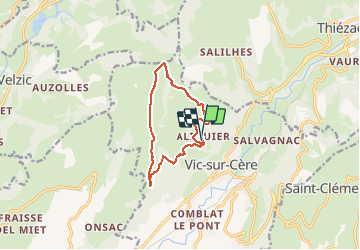
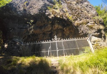
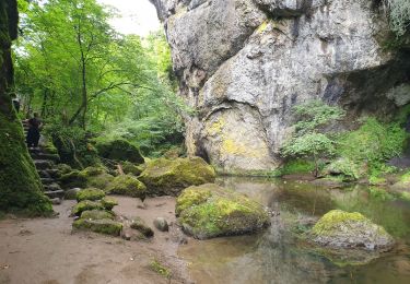
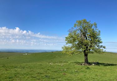
Trail Walking of 11.6 km to be discovered at Auvergne-Rhône-Alpes, Cantal, Vic-sur-Cère. This trail is proposed by denel.

Description

Boucle au départ de aliquier en passant par l'arbre de quenouille

Elevation profile

Positioning

Country:
France
Region :
Auvergne-Rhône-Alpes
Department/Province :
Cantal
Municipality :
Vic-sur-Cère
Location:
Unknown
Start:(UTM)
469861 ; 4981580 (31T) N.

Trails nearby

Trail Walking Thiézac - La Porte du Lion - Thiézac - Photo
Walking
tracegps

Walking

Medium
(2)
Thiézac, Auvergne-Rhône-Alpes, Cantal, France
6.6 km | 10.5 km-effort
3h 0min
Yes
Trail Walking Polminhac - Polminhac - Autour du donjon - Photo
Walking
tracegps

Walking

Easy
(1)
Polminhac, Auvergne-Rhône-Alpes, Cantal, France
5.2 km | 8.6 km-effort
2h 0min
Yes
Trail On foot Saint-Cirgues-de-Jordanne - Le Chaumeil - Photo
On foot
PRO

On foot

Easy
Saint-Cirgues-de-Jordanne, Auvergne-Rhône-Alpes, Cantal, France
8.2 km | 13.3 km-effort
3h 0min
Yes
Trail Walking Lascelle - Roman de Jordanne - Photo
Walking
zoe.vienne

Walking

Medium
(1)
Lascelle, Auvergne-Rhône-Alpes, Cantal, France
17.7 km | 27 km-effort
5h 54min
Yes
Trail Walking Thiézac - La porte du Lion - Thiézac - Photo
Walking
tracegps

Walking

Medium
(2)
Thiézac, Auvergne-Rhône-Alpes, Cantal, France
7.6 km | 11.5 km-effort
3h 30min
Yes
Trail Walking Vic-sur-Cère - Pas de Cère- cascade de Gourdole - Photo
Walking
crocau

Walking

Very easy
Vic-sur-Cère, Auvergne-Rhône-Alpes, Cantal, France
4.7 km | 6.6 km-effort
2h 0min
Yes
Trail Walking Thiézac - Puy de la poche  - Photo
Walking
nadd73

Walking

Easy
Thiézac, Auvergne-Rhône-Alpes, Cantal, France
13.1 km | 23 km-effort
3h 14min
Yes
Trail Walking Thiézac - Les Gorges du Pas de Cère - Photo
Walking
VacheKiri67

Walking

Easy
Thiézac, Auvergne-Rhône-Alpes, Cantal, France
4.8 km | 6.8 km-effort
2h 21min
Yes
Trail Walking Lascelle - Arbre de quenouille, rocher saint curial, col de berganti - Photo
Walking
impradine

Walking

Easy
Lascelle, Auvergne-Rhône-Alpes, Cantal, France
12.8 km | 19 km-effort
3h 37min
Yes


Close
My subscriptions