Trail Walking Gex - GEX : le Mont Mourex - Photo

GEX : le Mont Mourex

 otgex
otgex

User

© OpenStreetMap contributors
Length
Length
9.6 km
Max alt
Max alt
748 m
Uphill gradient
Uphill gradient
201 m
Km-Effort
Km-Effort  
12.2 km
Min alt
Min alt
574 m
Downhill gradient
Downhill gradient
199 m
Boucle
Boucle
Yes
Creation date :
2014-12-11 00:00:00.0
Updated on :
2014-12-11 00:00:00.0

(1 Reviews)

Walking
Walking
3h00
Difficulty : Unknown

Scan this QR Code to open this trail in the SityTrail application

FREE GPS app for hiking

Logo SityTrail SityTrail

IGN / Geographical institutes

Download SityTrail from the App Store Download SityTrail from Google Play

Logo SityTrail SityTrail World

The world is yours!

Download SityTrail from the App Store Download SityTrail from Google Play Download SityTrail on Huawei AppGallery

About

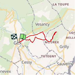
Trail Walking of 9.6 km to be discovered at Auvergne-Rhône-Alpes, Ain, Gex. This trail is proposed by otgex.

Description

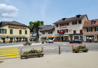
Départ de l''Office de Tourisme (1) ou du camping de Gex (2).

Depuis l''Office de Tourisme (chalet d''accueil à Gex), prenez la route de Divonne; passez devant le Musée des Sapeurs Pompiers (La Remise 01), puis juste après, prenez la voie de droite : direction le camping des "Genêts".

Après le pont, prenez à gauche le chemin en sous bois (balisage jaune) ; au croisement après le bâtiment taggué, entrez dans le lotissement. Reprenez la route goudronnée sur votre droite (face aux Alpes) puis prenez à gauche (3) (panneau balisage jaune), dans les champs ; Suivez les chemins agricoles.  

A la jonction de la route goudronnée, entrez dans "Mourex"  (panneau) (4).  Avant le virage en descente, (à hauteur d''une maison en pierre de taille), prenez sur votre gauche (direction le Jura) : le Chemin du "Mont (5). Il se termine par un gros chemin caillouteux puis un parking.  

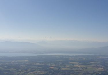
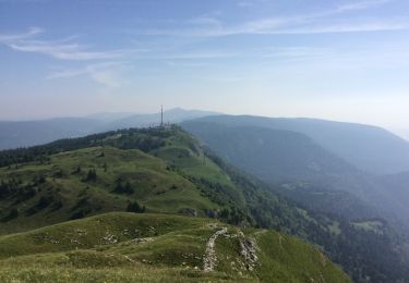
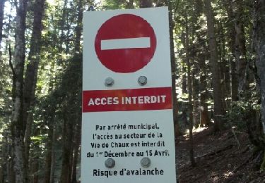
Suivez le balisage randonnée jaune. Après le portail du pâturage, vers le réservoir, montez par le chemin en direction de la butte à travers une vaste étendue herbeuse. Vous verrez au loin une borne jaune et la  table d''orientation, puis un peu plus loin, le sommet du Mont Mourex à 755 mètres d''altitude (banc et mégalithe). Profitez pleinement du magnifique panorama sur la Chaîne du Jura au Nord et le massif du Mont Blanc au Sud... Retour par le même itinéraire ou prenez la variante par la route goudronnée qui allonge l''itinéraire de 2 kilomètres.

Pour le retour, revenir sur le parking du Mont et reprendre l''itinéraire identique à l''aller.

Elevation profile

Photos

Points of interest

Point of interest Gex - 2) Camping - Photo
otgex
Point of interest Grilly - 5) ch du Mont - Photo
otgex
Point of interest Vesancy - variante Retour - Photo
otgex
Point of interest Grilly - 6) Arrivée - Photo
otgex
GRILLY 

Positioning

Country:
France
Region :
Auvergne-Rhône-Alpes
Department/Province :
Ain
Municipality :
Gex
Location:
Unknown
Start:(UTM)
273760 ; 5135175 (32T) N.

Comments

Please log in to post a review or rate the element


Trails nearby

Trail Running Mijoux - UTTJ 2015-2 - Photo
Running
bourel.jacques

Running

Very difficult
(1)
Mijoux, Auvergne-Rhône-Alpes, Ain, France
57 km | 92 km-effort
18h 13min
No
Trail Walking Gex - Balade à Col de la Faucille, Gex - Photo
Walking
Gaiato

Walking

Very difficult
Gex, Auvergne-Rhône-Alpes, Ain, France
86 km | 135 km-effort
9h 23min
No
Trail Bicycle tourism Mijoux - LES ROUSSES - COL DE LA FAUCILLE  - Photo
Bicycle tourism
jean-marie.parachini

Bicycle tourism

Very difficult
Mijoux, Auvergne-Rhône-Alpes, Ain, France
54 km | 68 km-effort
4h 57min
No
Trail Walking Gex - la faucille - montrond - Photo
Walking
thierrytm

Walking

Medium
Gex, Auvergne-Rhône-Alpes, Ain, France
12.4 km | 22 km-effort
1h 35min
No
Trail Walking Mijoux - GR 9 Étape 8 - Mijoux - Refuge de la Loge - Photo
Walking
pcugnod

Walking

Difficult
Mijoux, Auvergne-Rhône-Alpes, Ain, France
14.9 km | 24 km-effort
5h 37min
No
Trail Snowshoes Mijoux - MTROND 2019 - Photo
Snowshoes
UDGI54

Snowshoes

Difficult
(1)
Mijoux, Auvergne-Rhône-Alpes, Ain, France
9.2 km | 14.1 km-effort
2h 55min
No
Trail Walking Mijoux - Mijoux_Colomby de Gex D+ 1523 21.6 km 20150825 - Photo
Walking
cmike39

Walking

Very easy
Mijoux, Auvergne-Rhône-Alpes, Ain, France
22 km | 38 km-effort
8h 22min
No
Trail Walking Échenevex - Sources de l''Allondon - Echenevex - Photo
Walking
tracegps

Walking

Medium
Échenevex, Auvergne-Rhône-Alpes, Ain, France
3.5 km | 4.4 km-effort
2h 0min
Yes
Trail Walking Gex - Le colomby de gex - Photo
Walking
tippex01

Walking

Difficult
(1)
Gex, Auvergne-Rhône-Alpes, Ain, France
14 km | 24 km-effort
4h 30min
Yes


Close
My subscriptions