


koh mak

bilune
User
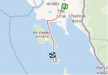

Length
68 km

Max alt
42 m

Uphill gradient
195 m
Km-Effort
71 km

Min alt
0 m

Downhill gradient
195 m
Boucle
No
Creation date :
2014-12-11 00:00:00.0
Updated on :
2014-12-11 00:00:00.0
3h44
Difficulty : Unknown

FREE GPS app for hiking
 SityTrail
IGN / Geographical institutes
SityTrail World
The world is yours!
About
Trail Other activity of 68 km to be discovered at Trat Province. This trail is proposed by bilune.
Photos


Positioning
Country:
Thailand
Region :
Trat Province
Department/Province :
Unknown
Municipality :
Unknown
Location:
Unknown
Start:(Dec)
Start:(UTM)
229096 ; 1355387 (48P) N.
Comments
Trails nearby