


Refuge Fond d'Aussois BS 2020 09 09

bstebe
User
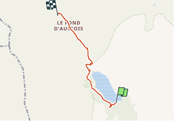

Length
4.3 km

Max alt
2349 m

Uphill gradient
298 m
Km-Effort
7.3 km

Min alt
2048 m

Downhill gradient
9 m
Boucle
No
Creation date :
2020-09-09 07:43:28.802
Updated on :
2020-09-09 13:37:26.185
1h22
Difficulty : Very easy

FREE GPS app for hiking
 SityTrail
IGN / Geographical institutes
SityTrail Plus
The world is yours!
About
Trail Walking of 4.3 km to be discovered at Auvergne-Rhône-Alpes, Savoy, Aussois. This trail is proposed by bstebe.
Positioning
Country:
France
Region :
Auvergne-Rhône-Alpes
Department/Province :
Savoy
Municipality :
Aussois
Location:
Unknown
Start:(Dec)
Start:(UTM)
321338 ; 5013776 (32T) N.
Comments