Trail Mountain bike Noble-Contrée -  - Photo
 maturin
maturin

User

© OpenStreetMap contributors
Length
Length
15.9 km
Max alt
Max alt
1358 m
Uphill gradient
Uphill gradient
806 m
Km-Effort
Km-Effort  
27 km
Min alt
Min alt
646 m
Downhill gradient
Downhill gradient
806 m
Boucle
Boucle
Yes
Creation date :
2014-12-11 00:00:00.0
Updated on :
2014-12-11 00:00:00.0

(0 Reviews)

Mountain bike
Mountain bike
1h58
Difficulty : Unknown

Scan this QR Code to open this trail in the SityTrail application

FREE GPS app for hiking

Logo SityTrail SityTrail

IGN / Geographical institutes

Download SityTrail from the App Store Download SityTrail from Google Play

Logo SityTrail SityTrail World

The world is yours!

Download SityTrail from the App Store Download SityTrail from Google Play Download SityTrail on Huawei AppGallery

About

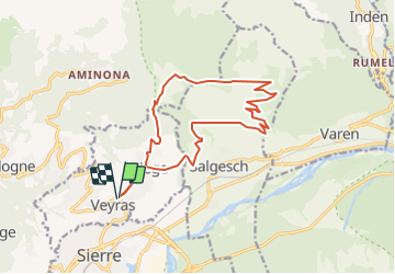
Trail Mountain bike of 15.9 km to be discovered at Valais/Wallis, Sierre, Noble-Contrée. This trail is proposed by maturin.

Description

Départ Veyras (645 m) , direction Miège. Suivre vers le terrain de foot et ensuite direction Salgesch.

Sur le haut de Salgesch, continuer à monter jusqu''au bisse. Suivre le bisse direction Varen. Dès le croisement de la route forestière, suivre celle-ci.

Le col se trouve sur cettre route forestière, devenu non goudronnée, à l''altitude 1350 m environ. Pour la descente suivre la route...ou ceux qui connaisse, suivre les chemin single trail. (comme noté sur le plan)

Elevation profile

Positioning

Country:
Switzerland
Region :
Valais/Wallis
Department/Province :
Sierre
Municipality :
Noble-Contrée
Location:
Unknown
Start:(UTM)
387479 ; 5128939 (32T) N.

Trails nearby

Trail Mountain bike Crans-Montana - Tour des villages - Photo
Mountain bike
GUIDE+

Mountain bike

Very easy
(1)
Crans-Montana, Valais/Wallis, Sierre, Switzerland
23 km | 35 km-effort
3h 0min
Yes
Trail On foot Crans-Montana - Plaine Morte-Les Violettes - Photo
On foot
PRO

On foot

Easy
Crans-Montana, Valais/Wallis, Sierre, Switzerland
4.5 km | 11.5 km-effort
2h 36min
No
Trail Walking Crans-Montana - Chemin du Vignoble - Itinéraire dégustation - Photo
Walking
GUIDE+

Walking

Very easy
Crans-Montana, Valais/Wallis, Sierre, Switzerland
7 km | 10.2 km-effort
2h 45min
No
Trail Walking Sierre - Sierre à Chandolin - Photo
Walking
chandolin

Walking

Very easy
(1)
Sierre, Valais/Wallis, Sierre, Switzerland
11.5 km | 28 km-effort
7h 24min
No
Trail Mountain bike Crans-Montana - Tour Hauts de Crans - Photo
Mountain bike
GUIDE+

Mountain bike

Very easy
Crans-Montana, Valais/Wallis, Sierre, Switzerland
7.8 km | 11.3 km-effort
1h 30min
Yes
Trail Walking Noble-Contrée - Bisse Neuf and Bisse de Varen - Photo
Walking
GUIDE+

Walking

Very easy
Noble-Contrée, Valais/Wallis, Sierre, Switzerland
10.5 km | 14.8 km-effort
3h 35min
No
Trail Walking Lens - Cry d’Er - pointe Plaine Morte - Photo
Walking
jpksenicz

Walking

Very difficult
Lens, Valais/Wallis, Sierre, Switzerland
16.3 km | 30 km-effort
5h 8min
No
Trail Walking Sierre - Promenade de Finges - Photo
Walking
GUIDE+

Walking

Very easy
Sierre, Valais/Wallis, Sierre, Switzerland
8.4 km | 10.4 km-effort
2h 29min
No
Trail Walking Crans-Montana - Crans-Montana, Terre de foi - Photo
Walking
GUIDE+

Walking

Very easy
Crans-Montana, Valais/Wallis, Sierre, Switzerland
16.4 km | 26 km-effort
8h 0min
Yes


Close
My subscriptions