Trail Walking Sainte-Marie-aux-Mines - Crête granitique et forêts profondes - Photo

Crête granitique et forêts profondes

© OpenStreetMap contributors
Length
Length
13.7 km
Max alt
Max alt
1019 m
Uphill gradient
Uphill gradient
647 m
Km-Effort
Km-Effort  
22 km
Min alt
Min alt
529 m
Downhill gradient
Downhill gradient
647 m
Boucle
Boucle
Yes
Creation date :
2020-09-20 08:12:22.253
Updated on :
2020-10-18 12:47:12.001

(0 Reviews)

Walking
Walking
3h56
Difficulty : Medium

Scan this QR Code to open this trail in the SityTrail application

FREE GPS app for hiking

Logo SityTrail SityTrail

IGN / Geographical institutes

Download SityTrail from the App Store Download SityTrail from Google Play

Logo SityTrail SityTrail World

The world is yours!

Download SityTrail from the App Store Download SityTrail from Google Play Download SityTrail on Huawei AppGallery

About

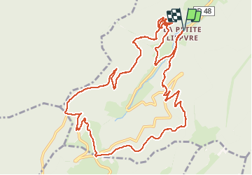
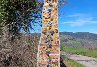
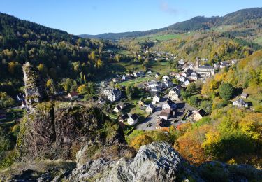
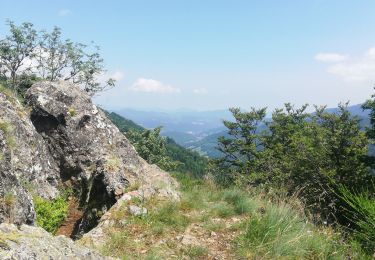
Trail Walking of 13.7 km to be discovered at Grand Est, Haut-Rhin, Sainte-Marie-aux-Mines. This trail is proposed by VacheKiri67.

Description

Faite le 20/09/2020. D'après "Passion Vosges - Escapade en Alsace Centrale" N°24 : Crête granitique et forêts profondes. Durée indiqué pour le circuit : 4h30. Départ : parking du parc minier Tellure.

Elevation profile

Photos

Positioning

Country:
France
Region :
Grand Est
Department/Province :
Haut-Rhin
Municipality :
Sainte-Marie-aux-Mines
Location:
Unknown
Start:(UTM)
361516 ; 5341665 (32U) N.

Trails nearby

Trail Walking Le Bonhomme - Le Bonhomme - Circuit du village - Photo
Walking
GUIDE
Desrumaux

Walking

Easy
(1)
Le Bonhomme, Grand Est, Haut-Rhin, France
3 km | 5.3 km-effort
1h 30min
Yes
Trail Walking Sainte-Marie-aux-Mines - 2021-02-14 Marche Bagenelles Brezouard Fuste de Etoile - Photo
Walking
GUIDE
holtzv

Walking

Very difficult
Sainte-Marie-aux-Mines, Grand Est, Haut-Rhin, France
17.1 km | 27 km-effort
6h 6min
Yes
Trail Walking Sainte-Marie-aux-Mines - 2020-06-20 Marche Tete du Violu Col de Ste Marie - Photo
Walking
GUIDE
holtzv

Walking

Very easy
Sainte-Marie-aux-Mines, Grand Est, Haut-Rhin, France
14.1 km | 21 km-effort
4h 14min
Yes
Trail Walking Ban-de-Laveline - 20130508 - Photo
Walking
pida

Walking

Very easy
(1)
Ban-de-Laveline, Grand Est, Vosges, France
7.6 km | 11.1 km-effort
2h 19min
Yes
Trail Walking Fréland - CVL - Rando 25/03/2024 - Col de Chamont - Photo
Walking
Hub6877

Walking

Medium
Fréland, Grand Est, Haut-Rhin, France
6.6 km | 9.5 km-effort
2h 15min
Yes
Trail On foot Sainte-Marie-aux-Mines - Le Haïcot - Le Petit Brézouard - Le Haïcot - Photo
On foot
patrickbeyrath

On foot

Easy
(2)
Sainte-Marie-aux-Mines, Grand Est, Haut-Rhin, France
7.1 km | 10.5 km-effort
2h 23min
Yes
Trail Walking Le Bonhomme - Le  Bonhomme-le Brézouard - Photo
Walking
oscar1

Walking

Medium
Le Bonhomme, Grand Est, Haut-Rhin, France
15 km | 26 km-effort
4h 34min
Yes
Trail Walking Sainte-Marie-aux-Mines - rocher des chèvred - Photo
Walking
apa

Walking

Difficult
(2)
Sainte-Marie-aux-Mines, Grand Est, Haut-Rhin, France
8.9 km | 13.3 km-effort
2h 40min
Yes
Trail Walking Gemaingoutte - col Sainte Marie aux mines - Photo
Walking
apa

Walking

Very difficult
Gemaingoutte, Grand Est, Vosges, France
14.5 km | 22 km-effort
4h 20min
Yes


Close
My subscriptions