Trail Walking Saint-Étienne-du-Grès - ND du Château - Photo
© OpenStreetMap contributors
Length
Length
10 km
Max alt
Max alt
157 m
Uphill gradient
Uphill gradient
267 m
Km-Effort
Km-Effort  
13.6 km
Min alt
Min alt
45 m
Downhill gradient
Downhill gradient
265 m
Boucle
Boucle
Yes
Creation date :
2014-12-10 00:00:00.0
Updated on :
2014-12-10 00:00:00.0

(1 Reviews)

Walking
Walking
2h59
Difficulty : Easy

Scan this QR Code to open this trail in the SityTrail application

FREE GPS app for hiking

Logo SityTrail SityTrail

IGN / Geographical institutes

Download SityTrail from the App Store Download SityTrail from Google Play

Logo SityTrail SityTrail World

The world is yours!

Download SityTrail from the App Store Download SityTrail from Google Play Download SityTrail on Huawei AppGallery

About

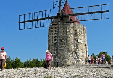
Trail Walking of 10 km to be discovered at Provence-Alpes-Côte d'Azur, Bouches-du-Rhône, Saint-Étienne-du-Grès. This trail is proposed by Amaralain.

Description

Départ du Mas de Pommet (St-Etienne du Grès) - cabane du Garde - prendre chemin à la 2° indication "Plan Redon" à gauche -

Elevation profile

Positioning

Country:
France
Region :
Provence-Alpes-Côte d'Azur
Department/Province :
Bouches-du-Rhône
Municipality :
Saint-Étienne-du-Grès
Location:
Unknown
Start:(UTM)
639474 ; 4847693 (31T) N.

Comments

Please log in to post a review or rate the element


Trails nearby

Trail Walking Fontvieille - Fontvieille sur les pas de Daudet  - Photo
Walking
tracegps

Walking

Medium
(3)
Fontvieille, Provence-Alpes-Côte d'Azur, Bouches-du-Rhône, France
12.8 km | 15.3 km-effort
2h 34min
Yes
Trail Walking Fontvieille - Fontvieille circuit bleu - Photo
Walking
didier.zimmermann

Walking

Very easy
(1)
Fontvieille, Provence-Alpes-Côte d'Azur, Bouches-du-Rhône, France
10.4 km | 12.7 km-effort
2h 46min
Yes
Trail Walking Les Baux-de-Provence - alpilles , les baux -st etienne du grès - Photo
Walking
ritchi

Walking

Medium
(1)
Les Baux-de-Provence, Provence-Alpes-Côte d'Azur, Bouches-du-Rhône, France
12.6 km | 16 km-effort
3h 32min
Yes
Trail Walking Tarascon - Chapelle Saint Gabriel - Photo
Walking
GUIDE
Roger Philippe Wallez

Walking

Very difficult
Tarascon, Provence-Alpes-Côte d'Azur, Bouches-du-Rhône, France
18.6 km | 25 km-effort
5h 23min
Yes
Trail Electric bike Les Baux-de-Provence - St_Remy_Canal2 - Photo
Electric bike
Fx Langloys

Electric bike

Easy
(1)
Les Baux-de-Provence, Provence-Alpes-Côte d'Azur, Bouches-du-Rhône, France
30 km | 35 km-effort
1h 55min
Yes
Trail Electric bike Les Baux-de-Provence - St_Remy_Canal1 - Photo
Electric bike
Fx Langloys

Electric bike

Easy
(1)
Les Baux-de-Provence, Provence-Alpes-Côte d'Azur, Bouches-du-Rhône, France
35 km | 42 km-effort
1h 55min
Yes
Trail Walking Tarascon - CR_Domitia_BA_23_Tarascon_St-Remy-Provence_20220404 - Photo
Walking
patrickdanilo

Walking

Medium
Tarascon, Provence-Alpes-Côte d'Azur, Bouches-du-Rhône, France
17 km | 22 km-effort
4h 42min
No
Trail On foot Saint-Rémy-de-Provence - Autour de La Léque - ST REMY de PROVENCE - Photo
On foot
chmauron

On foot

Easy
(1)
Saint-Rémy-de-Provence, Provence-Alpes-Côte d'Azur, Bouches-du-Rhône, France
11.1 km | 14.5 km-effort
3h 17min
Yes
Trail Walking Les Baux-de-Provence - Sensei34270 - Photo
Walking
rio34740

Walking

Les Baux-de-Provence, Provence-Alpes-Côte d'Azur, Bouches-du-Rhône, France
10.4 km | 13.8 km-effort
4h 7min
No


Close
My subscriptions