


Meriel Parmain

pmauvieux
User
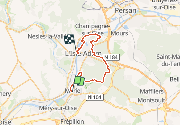

Length
18 km

Max alt
124 m

Uphill gradient
194 m
Km-Effort
21 km

Min alt
22 m

Downhill gradient
197 m
Boucle
No
Creation date :
2020-10-04 07:12:20.451
Updated on :
2020-10-04 11:02:36.166
3h41
Difficulty : Easy

FREE GPS app for hiking
 SityTrail
IGN / Geographical institutes
SityTrail Plus
The world is yours!
About
Trail Walking of 18 km to be discovered at Ile-de-France, Val-d'Oise, Mériel. This trail is proposed by pmauvieux.
Positioning
Country:
France
Region :
Ile-de-France
Department/Province :
Val-d'Oise
Municipality :
Mériel
Location:
Unknown
Start:(Dec)
Start:(UTM)
441877 ; 5436440 (31U) N.
Comments