Trail Trail Remiremont - TRAIL la 14-18 _ rev 24_11_2019 - Photo

TRAIL la 14-18 _ rev 24_11_2019

© OpenStreetMap contributors
Length
Length
9.4 km
Max alt
Max alt
593 m
Uphill gradient
Uphill gradient
314 m
Km-Effort
Km-Effort  
13.6 km
Min alt
Min alt
399 m
Downhill gradient
Downhill gradient
313 m
Boucle
Boucle
No
Creation date :
2020-10-16 12:57:50.018
Updated on :
2020-10-16 13:12:42.006

(0 Reviews)

Trail
Trail
--
Difficulty : Medium

Scan this QR Code to open this trail in the SityTrail application

FREE GPS app for hiking

Logo SityTrail SityTrail

IGN / Geographical institutes

Download SityTrail from the App Store Download SityTrail from Google Play

Logo SityTrail SityTrail World

The world is yours!

Download SityTrail from the App Store Download SityTrail from Google Play Download SityTrail on Huawei AppGallery

About

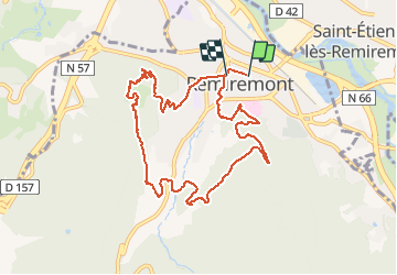
Trail Trail of 9.4 km to be discovered at Grand Est, Vosges, Remiremont. This trail is proposed by demange gerald.

Description

Trail organisé par AVPR
Départ dans la rue Charles De Gaulle
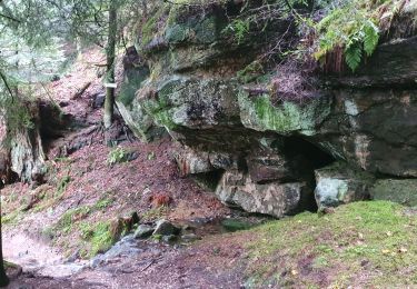
Montée jusqu'au Fort du Parmont,descente  par Lev Grand Beaulieu, le Pas de l'Ane, le sentier de découverte. Retour par le Calvaire, le parc des expositions.
Arrivée Place De Lattre

Elevation profile

Positioning

Country:
France
Region :
Grand Est
Department/Province :
Vosges
Municipality :
Remiremont
Location:
Unknown
Start:(UTM)
320477 ; 5320946 (32U) N.

Trails nearby

Trail On foot Raon-aux-Bois - Sentier
On foot
PRO

On foot

Medium
Raon-aux-Bois, Grand Est, Vosges, France
15.1 km | 21 km-effort
4h 42min
Yes
Trail Walking Remiremont - Remiremont (Girmont-Val-d'Ajol) 22 880m +729m - Photo
Walking
DanielROLLET

Walking

Very difficult
(1)
Remiremont, Grand Est, Vosges, France
23 km | 33 km-effort
7h 24min
Yes
Trail Walking Saint-Étienne-lès-Remiremont - rando chanoinesses 2024 - Photo
Walking
Le grand Claude

Walking

Medium
Saint-Étienne-lès-Remiremont, Grand Est, Vosges, France
12.5 km | 18 km-effort
2h 32min
No
Trail Walking Saint-Étienne-lès-Remiremont - 20220324_projet_rando_ST-ETIENNE-LES-REMIREMONT_N_Sur_les_pas_de_St_Romary - Photo
Walking
nfranche

Walking

Very difficult
Saint-Étienne-lès-Remiremont, Grand Est, Vosges, France
15.8 km | 25 km-effort
5h 36min
Yes
Trail On foot Raon-aux-Bois - Sentier
On foot
PRO

On foot

Easy
Raon-aux-Bois, Grand Est, Vosges, France
4.6 km | 7.3 km-effort
1h 39min
No
Trail On foot Saint-Nabord - Sentier
On foot
PRO

On foot

Easy
Saint-Nabord, Grand Est, Vosges, France
8.6 km | 11.4 km-effort
2h 35min
Yes
Trail Walking Saint-Étienne-lès-Remiremont - Le sentier des Pourdingues - Photo
Walking
viam19

Walking

Easy
Saint-Étienne-lès-Remiremont, Grand Est, Vosges, France
10.7 km | 15.3 km-effort
2h 25min
Yes
Trail Walking Remiremont - Remiremont - baraque des gardes - étang du Villerain - cascade du Géhart - étangs et prieuré d'Hérival  - Photo
Walking
Bart2015

Walking

Medium
Remiremont, Grand Est, Vosges, France
16.6 km | 23 km-effort
5h 19min
Yes
Trail Walking Remiremont - 2016 02 26 - Photo
Walking
michelbauby

Walking

Medium
Remiremont, Grand Est, Vosges, France
18.4 km | 28 km-effort
5h 19min
Yes


Close
My subscriptions