Trail Walking Névache - AR Roubion  - Photo
© OpenStreetMap contributors
Length
Length
4.9 km
Max alt
Max alt
1627 m
Uphill gradient
Uphill gradient
71 m
Km-Effort
Km-Effort  
5.8 km
Min alt
Min alt
1582 m
Downhill gradient
Downhill gradient
77 m
Boucle
Boucle
No
Creation date :
2020-10-21 16:22:56.407
Updated on :
2020-10-21 16:46:46.885

(0 Reviews)

Walking
Walking
1h16
Difficulty : Easy

Scan this QR Code to open this trail in the SityTrail application

FREE GPS app for hiking

Logo SityTrail SityTrail

IGN / Geographical institutes

Download SityTrail from the App Store Download SityTrail from Google Play

Logo SityTrail SityTrail World

The world is yours!

Download SityTrail from the App Store Download SityTrail from Google Play Download SityTrail on Huawei AppGallery

About

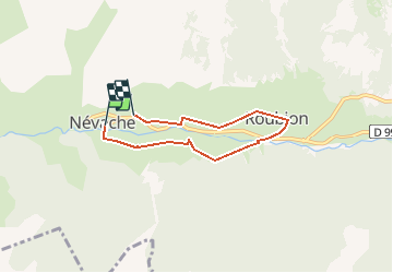
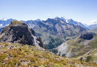
Trail Walking of 4.9 km to be discovered at Provence-Alpes-Côte d'Azur, Hautes-Alpes, Névache. This trail is proposed by Veilhan .

Description

 depart de l'église  passage par la rve droite et retour par la rive Gauchecompter 2 heures avec petite halte à Roubion

Elevation profile

Positioning

Country:
France
Region :
Provence-Alpes-Côte d'Azur
Department/Province :
Hautes-Alpes
Municipality :
Névache
Location:
Unknown
Start:(UTM)
311269 ; 4987807 (32T) N.

Trails nearby

Trail Walking Névache - Briançonnais Lac du Serpent - Photo
Walking
Orcal37

Walking

Medium
(2)
Névache, Provence-Alpes-Côte d'Azur, Hautes-Alpes, France
10 km | 18 km-effort
3h 10min
Yes
Trail Walking Névache - Col du Chardonnet - Névache - Photo
Walking
tracegps

Walking

Medium
(3)
Névache, Provence-Alpes-Côte d'Azur, Hautes-Alpes, France
12.3 km | 23 km-effort
4h 0min
Yes
Trail Walking Névache - Via Alpina - R127: Névache > Le Monêtier-les-Bains - Photo
Walking
tracegps

Walking

Difficult
(1)
Névache, Provence-Alpes-Côte d'Azur, Hautes-Alpes, France
15.5 km | 28 km-effort
5h 0min
No
Trail Walking Névache - Lacs Laramon et Serpent - Photo
Walking
neoroll44

Walking

Medium
(2)
Névache, Provence-Alpes-Côte d'Azur, Hautes-Alpes, France
10.4 km | 21 km-effort
6h 0min
Yes
Trail Walking Névache - lacs laramon, du serpent, des gardioles et pic du lac blanc - Photo
Walking
GUIDE
amiral13

Walking

Medium
(1)
Névache, Provence-Alpes-Côte d'Azur, Hautes-Alpes, France
15.8 km | 31 km-effort
7h 30min
Yes
Trail Walking Névache - LA CLAREE: balcon de la claree - Photo
Walking
lebarbe_b@hotmail.fr

Walking

Medium
Névache, Provence-Alpes-Côte d'Azur, Hautes-Alpes, France
14.2 km | 23 km-effort
4h 7min
Yes
Trail Walking Névache - Col des Thures - Lac Chavillon - Photo
Walking
astro45

Walking

Medium
Névache, Provence-Alpes-Côte d'Azur, Hautes-Alpes, France
5.3 km | 11.1 km-effort
2h 31min
No
Trail Walking Névache - Lac Laramon - Refuge Ricou - Photo
Walking
astro45

Walking

Medium
Névache, Provence-Alpes-Côte d'Azur, Hautes-Alpes, France
3.5 km | 8.4 km-effort
1h 54min
No
Trail Walking Névache - Col du Chardonnet - Photo
Walking
astro45

Walking

Medium
Névache, Provence-Alpes-Côte d'Azur, Hautes-Alpes, France
6.5 km | 14.1 km-effort
2h 58min
No


Close
My subscriptions