Trail Walking Lavelanet - Lavelanet - Au tour du Camping Village des Bons-Hommes - Photo

Lavelanet - Au tour du Camping Village des Bons-Hommes

 jopost
jopost

User

© OpenStreetMap contributors
Length
Length
2 km
Max alt
Max alt
563 m
Uphill gradient
Uphill gradient
20 m
Km-Effort
Km-Effort  
2.3 km
Min alt
Min alt
544 m
Downhill gradient
Downhill gradient
20 m
Boucle
Boucle
Yes
Creation date :
2020-10-25 10:34:04.718
Updated on :
2021-06-07 17:17:48.091

(0 Reviews)

Walking
Walking
55m
Difficulty : Very easy

Scan this QR Code to open this trail in the SityTrail application

FREE GPS app for hiking

Logo SityTrail SityTrail

IGN / Geographical institutes

Download SityTrail from the App Store Download SityTrail from Google Play

Logo SityTrail SityTrail World

The world is yours!

Download SityTrail from the App Store Download SityTrail from Google Play Download SityTrail on Huawei AppGallery

About

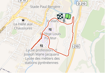
Trail Walking of 2 km to be discovered at Occitania, Ariège, Lavelanet. This trail is proposed by jopost.

Description

Voici une petite balade de 2 km depuis le Camping Village des Bons-Hommes vers la cascade du Lycée Jacquard et retour en longeant le camping par le bois. balade très agréable

Elevation profile

Positioning

Country:
France
Region :
Occitania
Department/Province :
Ariège
Municipality :
Lavelanet
Location:
Unknown
Start:(UTM)
405701 ; 4752988 (31T) N.

Trails nearby

Trail Electric bike Lavelanet - Lavelanet Ste Colombe lac Montbel retour Laroque  - Photo
Electric bike
jopost

Electric bike

Medium
Lavelanet, Occitania, Ariège, France
40 km | 44 km-effort
4h 30min
Yes
Trail Walking Fougax-et-Barrineuf - cols du figuier et de Ballussou et croix de Morenci depuis Fougax 09 - Photo
Walking
chrisgps

Walking

Easy
Fougax-et-Barrineuf, Occitania, Ariège, France
12.9 km | 21 km-effort
6h 55min
Yes
Trail On foot Laroque-d'Olmes - Les Crètes du Plantaurel - Photo
On foot
PRO

On foot

Easy
Laroque-d'Olmes, Occitania, Ariège, France
11.8 km | 17.3 km-effort
3h 55min
Yes
Trail Walking Montferrier - découverte du château de montsegur et du village par montferroer - Photo
Walking
fab0202

Walking

Medium
Montferrier, Occitania, Ariège, France
12.6 km | 21 km-effort
3h 42min
Yes
Trail Walking Lavelanet - Camping Village des Bons-Hommes pour balade-grillade - Photo
Walking
jopost

Walking

Very easy
Lavelanet, Occitania, Ariège, France
4.8 km | 6.5 km-effort
2h 14min
Yes
Trail Walking Montferrier - Sentier cathare - Château de Montsegur - Photo
Walking
toutankhcarton

Walking

Medium
Montferrier, Occitania, Ariège, France
12.6 km | 21 km-effort
4h 48min
Yes
Trail Walking Lavelanet - BOUCLE Ste Rufine, Raissac, Péreille d'en Bas et Haut, retour Cambière Bensa - Photo
Walking
jopost

Walking

Easy
Lavelanet, Occitania, Ariège, France
13.3 km | 21 km-effort
4h 34min
Yes
Trail Walking Lavelanet - boucle soula le bac  - Photo
Walking
jopost

Walking

Difficult
Lavelanet, Occitania, Ariège, France
7.3 km | 10.8 km-effort
3h 13min
Yes
Trail Walking Lavelanet - Tour de Péreille - Photo
Walking
RR31

Walking

Very easy
Lavelanet, Occitania, Ariège, France
14.7 km | 19.1 km-effort
4h 3min
Yes


Close
My subscriptions