Trail Mountain bike Aigle - Le chemin du Sel - Photo
 otrement
otrement

User

© OpenStreetMap contributors
Length
Length
22 km
Max alt
Max alt
982 m
Uphill gradient
Uphill gradient
766 m
Km-Effort
Km-Effort  
32 km
Min alt
Min alt
389 m
Downhill gradient
Downhill gradient
766 m
Boucle
Boucle
Yes
Creation date :
2014-12-11 00:00:00.0
Updated on :
2014-12-11 00:00:00.0

(0 Reviews)

Mountain bike
Mountain bike
2h34
Difficulty : Unknown

Scan this QR Code to open this trail in the SityTrail application

FREE GPS app for hiking

Logo SityTrail SityTrail

IGN / Geographical institutes

Download SityTrail from the App Store Download SityTrail from Google Play

Logo SityTrail SityTrail World

The world is yours!

Download SityTrail from the App Store Download SityTrail from Google Play Download SityTrail on Huawei AppGallery

About

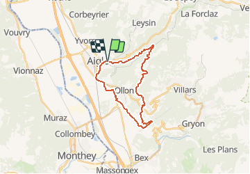
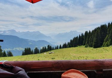
Trail Mountain bike of 22 km to be discovered at Vaud, District d'Aigle, Aigle. This trail is proposed by otrement.

Description

Au départ d''Aigle, nous montons vers le parc aventure et continuons à longer la Grande Eau jusqu''à la halte de Plambuit. C''est là que début le chemin du sel qui nous guide jusqu''à Antagnes en passant par Panex. De belle portion de single idéal pour les débuts de saison et les débutants. Le retour ce fait par la route.

Elevation profile

Points of interest

Point of interest Ollon - Super single - Photo
otrement
Point of interest Aigle - Halt Plambuit - Photo
otrement
Point of interest Aigle - En bord de route - Photo
otrement
Point of interest Ollon - La Gryonne - Photo
otrement
OLLON 

Positioning

Country:
Switzerland
Region :
Vaud
Department/Province :
District d'Aigle
Municipality :
Aigle
Location:
Unknown
Start:(UTM)
344439 ; 5131247 (32T) N.

Trails nearby

Trail On foot Ollon - Sentier du Sel - Photo
On foot
PRO

On foot

Easy
Ollon, Vaud, District d'Aigle, Switzerland
4.5 km | 8 km-effort
1h 49min
No
Trail Walking Leysin - la Rionda - Photo
Walking
rufi

Walking

Medium
Leysin, Vaud, District d'Aigle, Switzerland
7.4 km | 11.2 km-effort
2h 33min
No
Trail Walking Roche (VD) - Boucle d Arvel Joux Verte  - Photo
Walking
pawenger

Walking

Medium
Roche (VD), Vaud, District d'Aigle, Switzerland
6.9 km | 18.7 km-effort
1h 44min
Yes
Trail Other activity Leysin - bdr00_Leysin_StGingolphe - Photo
Other activity
GUIDE+

Other activity

Very easy
Leysin, Vaud, District d'Aigle, Switzerland
26 km | 32 km-effort
Unknown
No
Trail Other activity Leysin - xxx00_Leysin_StGingolphe - Photo
Other activity
GUIDE+

Other activity

Very easy
Leysin, Vaud, District d'Aigle, Switzerland
26 km | 32 km-effort
6h 41min
No
Trail Mountain bike Leysin - Bike32915 - Photo
Mountain bike
GUIDE+

Mountain bike

Very easy
Leysin, Vaud, District d'Aigle, Switzerland
30 km | 49 km-effort
Unknown
Yes
Trail Walking Leysin - solacyre - Photo
Walking
rufi

Walking

Easy
Leysin, Vaud, District d'Aigle, Switzerland
2.7 km | 6.3 km-effort
1h 20min
No
Trail Mountain bike Aigle - m-zwitserland-alpine-bike - Photo
Mountain bike
gpstracks

Mountain bike

Very easy
Aigle, Vaud, District d'Aigle, Switzerland
660 km | 988 km-effort
Unknown
No
Trail Snowshoes Leysin - Solacyre - Photo
Snowshoes
siejcsal

Snowshoes

Medium
Leysin, Vaud, District d'Aigle, Switzerland
7.4 km | 12.9 km-effort
2h 53min
Yes


Close
My subscriptions