Trail Walking Sentheim - Sentheimtour Covid série 2 - Photo

Sentheimtour Covid série 2

 helmut68
helmut68

User

© OpenStreetMap contributors
Length
Length
4.5 km
Max alt
Max alt
403 m
Uphill gradient
Uphill gradient
52 m
Km-Effort
Km-Effort  
5.2 km
Min alt
Min alt
359 m
Downhill gradient
Downhill gradient
49 m
Boucle
Boucle
Yes
Creation date :
2020-11-14 14:21:25.267
Updated on :
2020-11-14 18:28:03.861

(0 Reviews)

Walking
Walking
53m
Difficulty : Easy

Scan this QR Code to open this trail in the SityTrail application

FREE GPS app for hiking

Logo SityTrail SityTrail

IGN / Geographical institutes

Download SityTrail from the App Store Download SityTrail from Google Play

Logo SityTrail SityTrail World

The world is yours!

Download SityTrail from the App Store Download SityTrail from Google Play Download SityTrail on Huawei AppGallery

About

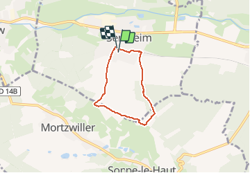
Trail Walking of 4.5 km to be discovered at Grand Est, Haut-Rhin, Sentheim. This trail is proposed by helmut68.

Description

Départ et arrivée à la place de jeux de Sentheim. Cette boucle permet de se ressourcer tout en respectant les règles de ce nouveau confinement : 1 heure , 1 km par jour .
Traversez le nouveau lotissement pour rejoindre la piste cyclable. Au niveau de la gare ,prenez à droite et suivez le balisage " croix jaune " , puis après 2 km suivez le balisage du GR 531 " rectangle bleu "( pendant 1 km ) pour rejoindre la route de Mortzwiller qui vous mènera à la place de jeux.
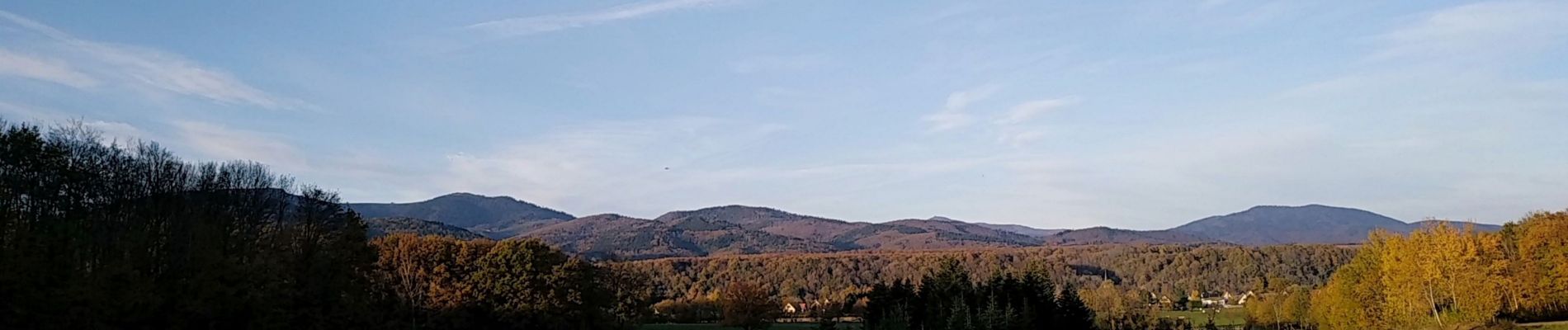
Parcours qui alterne forêt , sentiers et routes avec des vues splendides du Grand Ballon , du Rossberg , de la Forêt Noire ( dépend de la météo ) mais aussi de notre village ...
Alors à vos chaussures !

Elevation profile

Photos

Positioning

Country:
France
Region :
Grand Est
Department/Province :
Haut-Rhin
Municipality :
Sentheim
Location:
Unknown
Start:(UTM)
353920 ; 5290642 (32T) N.

Trails nearby

Trail Walking Masevaux-Niederbruck - Masevaux - Rossberg par le belvédère du Fuchsfelsen - Photo
Walking
Bart2015

Walking

Medium
(1)
Masevaux-Niederbruck, Grand Est, Haut-Rhin, France
19.9 km | 34 km-effort
4h 44min
Yes
Trail Walking Sentheim - Sentheim Rossberg - Photo
Walking
helmut68

Walking

Medium
(1)
Sentheim, Grand Est, Haut-Rhin, France
27 km | 40 km-effort
6h 11min
Yes
Trail Walking Lauw - 2022-07-14 Marche Lauw Refuge CAF Baerenkopf - Photo
Walking
GUIDE
holtzv

Walking

Very difficult
Lauw, Grand Est, Haut-Rhin, France
18.4 km | 31 km-effort
5h 35min
No
Trail On foot Sentheim - Sentier géologique du Wolfloch - Photo
On foot
PRO

On foot

Easy
Sentheim, Grand Est, Haut-Rhin, France
3.8 km | 4.8 km-effort
1h 5min
No
Trail On foot Sentheim - Sentheim - Bergwald - Eichwald - Guevenheim - Sentheim - Photo
On foot
patrickbeyrath

On foot

Easy
(1)
Sentheim, Grand Est, Haut-Rhin, France
13.4 km | 16.6 km-effort
Unknown
Yes
Trail Walking Sentheim - Knapphutte Saegenkopf Hütte - Photo
Walking
helmut68

Walking

Medium
Sentheim, Grand Est, Haut-Rhin, France
13.8 km | 17.2 km-effort
5h 11min
Yes
Trail Walking Sentheim - Montori - Photo
Walking
helmut68

Walking

Medium
Sentheim, Grand Est, Haut-Rhin, France
17.7 km | 24 km-effort
4h 47min
Yes
Trail Mountain bike Sentheim - AperoDioller - Photo
Mountain bike
helmut68

Mountain bike

Easy
Sentheim, Grand Est, Haut-Rhin, France
24 km | 27 km-effort
1h 23min
Yes
Trail Walking Sentheim - Baerenkopf  - Photo
Walking
helmut68

Walking

Difficult
Sentheim, Grand Est, Haut-Rhin, France
33 km | 49 km-effort
7h 0min
Yes


Close
My subscriptions