Trail Walking Sentheim - Sentheimtour Covid série 2 bis - Photo

Sentheimtour Covid série 2 bis

 helmut68
helmut68

User

© OpenStreetMap contributors
Length
Length
5.2 km
Max alt
Max alt
406 m
Uphill gradient
Uphill gradient
70 m
Km-Effort
Km-Effort  
6.1 km
Min alt
Min alt
359 m
Downhill gradient
Downhill gradient
67 m
Boucle
Boucle
Yes
Creation date :
2020-11-15 14:13:13.276
Updated on :
2020-11-15 23:55:34.744

(0 Reviews)

Walking
Walking
54m
Difficulty : Easy

Scan this QR Code to open this trail in the SityTrail application

FREE GPS app for hiking

Logo SityTrail SityTrail

IGN / Geographical institutes

Download SityTrail from the App Store Download SityTrail from Google Play

Logo SityTrail SityTrail World

The world is yours!

Download SityTrail from the App Store Download SityTrail from Google Play Download SityTrail on Huawei AppGallery

About

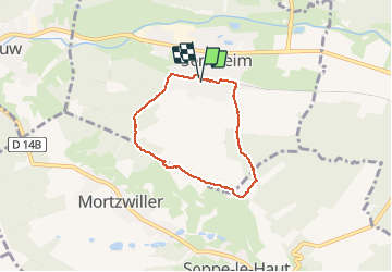
Trail Walking of 5.2 km to be discovered at Grand Est, Haut-Rhin, Sentheim. This trail is proposed by helmut68.

Description

Belle boucle qui permet de respecter les règles du confinement série 2 ( 1 heure, 1 km par jour ) départ et arrivée place de jeux de Sentheim.
Traversez le nouveau lotissement pour rejoindre la piste cyclable . Au niveau de la gare,tournez sur votre droite pour suivre le balisage " croix jaune " sur environ 2 km , puis le GR 531 balisage " rectangle bleu " ( direction   Lauw ) . Après avoir traversé la route de Mortzwiller , suivez toujours le balisage " rectangle bleu " sur environ 500 m ,puis au niveau de l'oratoire ,tournez à droite et suivez le balisage " triangle vert " jusqu'à Sentheim.
Parcours qui alterne chemins forestiers et sentiers avec des vues splendides du Grand Ballon , du Rossberg , des Alpes Suisse si la météo le permet , bref un bol d'air qui fait du bien ...
Alors à vos chaussures !

Elevation profile

Photos

Positioning

Country:
France
Region :
Grand Est
Department/Province :
Haut-Rhin
Municipality :
Sentheim
Location:
Unknown
Start:(UTM)
353919 ; 5290652 (32T) N.

Trails nearby

Trail Walking Masevaux-Niederbruck - Masevaux - Rossberg par le belvédère du Fuchsfelsen - Photo
Walking
Bart2015

Walking

Medium
(1)
Masevaux-Niederbruck, Grand Est, Haut-Rhin, France
19.9 km | 34 km-effort
4h 44min
Yes
Trail Walking Sentheim - Sentheim Rossberg - Photo
Walking
helmut68

Walking

Medium
(1)
Sentheim, Grand Est, Haut-Rhin, France
27 km | 40 km-effort
6h 11min
Yes
Trail Walking Lauw - 2022-07-14 Marche Lauw Refuge CAF Baerenkopf - Photo
Walking
GUIDE
holtzv

Walking

Very difficult
Lauw, Grand Est, Haut-Rhin, France
18.4 km | 31 km-effort
5h 35min
No
Trail On foot Sentheim - Sentier géologique du Wolfloch - Photo
On foot
PRO

On foot

Easy
Sentheim, Grand Est, Haut-Rhin, France
3.8 km | 4.8 km-effort
1h 5min
No
Trail On foot Sentheim - Sentheim - Bergwald - Eichwald - Guevenheim - Sentheim - Photo
On foot
patrickbeyrath

On foot

Easy
(1)
Sentheim, Grand Est, Haut-Rhin, France
13.4 km | 16.6 km-effort
Unknown
Yes
Trail Walking Sentheim - Knapphutte Saegenkopf Hütte - Photo
Walking
helmut68

Walking

Medium
Sentheim, Grand Est, Haut-Rhin, France
13.8 km | 17.2 km-effort
5h 11min
Yes
Trail Walking Sentheim - Montori - Photo
Walking
helmut68

Walking

Medium
Sentheim, Grand Est, Haut-Rhin, France
17.7 km | 24 km-effort
4h 47min
Yes
Trail Mountain bike Sentheim - AperoDioller - Photo
Mountain bike
helmut68

Mountain bike

Easy
Sentheim, Grand Est, Haut-Rhin, France
24 km | 27 km-effort
1h 23min
Yes
Trail Walking Sentheim - Baerenkopf  - Photo
Walking
helmut68

Walking

Difficult
Sentheim, Grand Est, Haut-Rhin, France
33 km | 49 km-effort
7h 0min
Yes


Close
My subscriptions