Trail Mountain bike Champigny-lès-Langres - Tour de la Liez depuis champigny  - Photo

Tour de la Liez depuis champigny

 jeaugey
jeaugey

User

© OpenStreetMap contributors
Length
Length
25 km
Max alt
Max alt
395 m
Uphill gradient
Uphill gradient
284 m
Km-Effort
Km-Effort  
28 km
Min alt
Min alt
333 m
Downhill gradient
Downhill gradient
284 m
Boucle
Boucle
Yes
Creation date :
2020-12-06 12:54:24.0
Updated on :
2020-12-06 15:04:05.13

(0 Reviews)

Mountain bike
Mountain bike
1h43
Difficulty : Unknown

Scan this QR Code to open this trail in the SityTrail application

FREE GPS app for hiking

Logo SityTrail SityTrail

IGN / Geographical institutes

Download SityTrail from the App Store Download SityTrail from Google Play

Logo SityTrail SityTrail World

The world is yours!

Download SityTrail from the App Store Download SityTrail from Google Play Download SityTrail on Huawei AppGallery

About

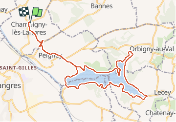
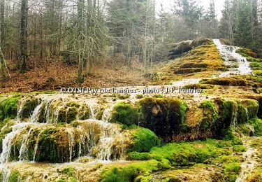
Trail Mountain bike of 25 km to be discovered at Grand Est, Haute-Marne, Champigny-lès-Langres. This trail is proposed by jeaugey.

Description

Randonnée VTT très facile

Elevation profile

Positioning

Country:
France
Region :
Grand Est
Department/Province :
Haute-Marne
Municipality :
Champigny-lès-Langres
Location:
Unknown
Start:(UTM)
675507 ; 5307293 (31T) N.

Trails nearby

Trail Cycle Langres - Boucle 1 autour de la Voie Verte - Langres - Photo
Cycle
tracegps

Cycle

Medium
(1)
Langres, Grand Est, Haute-Marne, France
23 km | 28 km-effort
1h 15min
Yes
Trail Hybrid bike Peigney - Tour du lac de la Liez et passage par le lac de Charmes - Photo
Hybrid bike
Tomtom88210

Hybrid bike

Easy
Peigney, Grand Est, Haute-Marne, France
36 km | 41 km-effort
2h 43min
Yes
Trail Mountain bike Peigney - Tour du lac de la Liez - Langres - Photo
Mountain bike
tracegps

Mountain bike

Medium
Peigney, Grand Est, Haute-Marne, France
16.1 km | 18.3 km-effort
2h 0min
No
Trail Walking Peigney - Tour du lac de la Liez - Langres - Photo
Walking
tracegps

Walking

Medium
Peigney, Grand Est, Haute-Marne, France
16.1 km | 18.3 km-effort
4h 0min
No
Trail Cycle Langres - Tour des 4 lacs - Langres - Photo
Cycle
tracegps

Cycle

Difficult
Langres, Grand Est, Haute-Marne, France
75 km | 88 km-effort
6h 15min
Yes
Trail Cycle Peigney - Entre Lacs et Canal - Lac de la Liez - Photo
Cycle
tracegps

Cycle

Medium
(1)
Peigney, Grand Est, Haute-Marne, France
33 km | 37 km-effort
2h 0min
Yes
Trail Cycle Langres - Entre Plateau de Langres et Montagne - Photo
Cycle
tracegps

Cycle

Difficult
Langres, Grand Est, Haute-Marne, France
115 km | 138 km-effort
4h 0min
Yes
Trail Mountain bike Langres - La Via Francigena - Traversée de la Haute Marne -de Langres à Culmont - Photo
Mountain bike
tracegps

Mountain bike

Medium
Langres, Grand Est, Haute-Marne, France
23 km | 26 km-effort
2h 0min
No
Trail Walking Langres - La Via Francigena - Traversée de la Haute Marne -de Langres à Culmont - Photo
Walking
tracegps

Walking

Medium
Langres, Grand Est, Haute-Marne, France
23 km | 26 km-effort
4h 30min
No


Close
My subscriptions