


exercise_tcx_file

Lucquiaud
User

Length
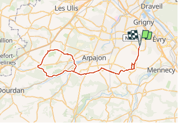
61 km

Max alt
139 m

Uphill gradient
471 m
Km-Effort
68 km

Min alt
51 m

Downhill gradient
470 m
Boucle
Yes
Creation date :
2021-01-31 19:50:37.433
Updated on :
2021-02-26 16:12:04.161
4h05
Difficulty : Medium

FREE GPS app for hiking
 SityTrail
IGN / Geographical institutes
SityTrail Plus
The world is yours!
About
Trail Road bike of 61 km to be discovered at Ile-de-France, Essonne, Bondoufle. This trail is proposed by Lucquiaud.
Positioning
Country:
France
Region :
Ile-de-France
Department/Province :
Essonne
Municipality :
Bondoufle
Location:
Unknown
Start:(Dec)
Start:(UTM)
453992 ; 5384462 (31U) N.
Comments