


CCA Beblenhe

Gatge
User
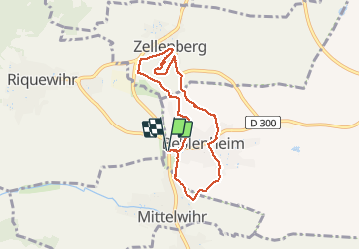

Length
6.6 km

Max alt
298 m

Uphill gradient
126 m
Km-Effort
8.3 km

Min alt
209 m

Downhill gradient
127 m
Boucle
Yes
Creation date :
2021-03-10 12:33:58.116
Updated on :
2021-03-10 14:53:55.898
2h19
Difficulty : Very easy

FREE GPS app for hiking
 SityTrail
IGN / Geographical institutes
SityTrail Plus
The world is yours!
About
Trail Walking of 6.6 km to be discovered at Grand Est, Haut-Rhin, Beblenheim. This trail is proposed by Gatge.
Positioning
Country:
France
Region :
Grand Est
Department/Province :
Haut-Rhin
Municipality :
Beblenheim
Location:
Unknown
Start:(Dec)
Start:(UTM)
375046 ; 5335206 (32U) N.
Comments