Trail Walking Rigny-Saint-Martin - st fiacre-choloy - Photo
 mannequ1
mannequ1

User

© OpenStreetMap contributors
Length
Length
18.6 km
Max alt
Max alt
409 m
Uphill gradient
Uphill gradient
310 m
Km-Effort
Km-Effort  
23 km
Min alt
Min alt
242 m
Downhill gradient
Downhill gradient
314 m
Boucle
Boucle
Yes
Creation date :
2014-12-10 00:00:00.0
Updated on :
2014-12-10 00:00:00.0

(0 Reviews)

Walking
Walking
3h56
Difficulty : Medium

Scan this QR Code to open this trail in the SityTrail application

FREE GPS app for hiking

Logo SityTrail SityTrail

IGN / Geographical institutes

Download SityTrail from the App Store Download SityTrail from Google Play

Logo SityTrail SityTrail World

The world is yours!

Download SityTrail from the App Store Download SityTrail from Google Play Download SityTrail on Huawei AppGallery

About

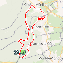
Trail Walking of 18.6 km to be discovered at Grand Est, Meuse, Rigny-Saint-Martin. This trail is proposed by mannequ1.

Elevation profile

Photos

Points of interest

Point of interest Domgermain - Point 1 - Photo
mannequ1
DOMGERMAIN 

Positioning

Country:
France
Region :
Grand Est
Department/Province :
Meuse
Municipality :
Rigny-Saint-Martin
Location:
Unknown
Start:(UTM)
706214 ; 5388265 (31U) N.

Trails nearby

Trail On foot Choloy-Ménillot - Boucle des Sources - Photo
On foot
PRO

On foot

Easy
Choloy-Ménillot, Grand Est, Meurthe-et-Moselle, France
10.4 km | 11.9 km-effort
2h 42min
No
Trail Walking Bulligny - BULLIGNY - LE BOIS BRULE - Photo
Walking
jean-marie.parachini

Walking

Easy
Bulligny, Grand Est, Meurthe-et-Moselle, France
8.8 km | 11.4 km-effort
4h 11min
Yes
Trail Walking Charmes-la-Côte - Circuit saint -Fiacre - Photo
Walking
Samuel88300

Walking

Charmes-la-Côte, Grand Est, Meurthe-et-Moselle, France
11 km | 14.3 km-effort
2h 59min
Yes
Trail Nordic walking Domgermain - Marche au palteau de Domgermain - Photo
Nordic walking
SANTINI

Nordic walking

Easy
Domgermain, Grand Est, Meurthe-et-Moselle, France
8.6 km | 10.1 km-effort
1h 29min
Yes
Trail Walking Blénod-lès-Toul - rando 12km vers Bulligny - Photo
Walking
sandra54570

Walking

Difficult
Blénod-lès-Toul, Grand Est, Meurthe-et-Moselle, France
11.9 km | 15.6 km-effort
1h 36min
Yes
Trail Walking Domgermain - donges - Photo
Walking
noelphil

Walking

Difficult
Domgermain, Grand Est, Meurthe-et-Moselle, France
11.5 km | 14.9 km-effort
3h 10min
Yes
Trail sport Domgermain - Domgermain  - Photo
sport
Arnaud Leon

sport

Very easy
Domgermain, Grand Est, Meurthe-et-Moselle, France
5.8 km | 6.9 km-effort
Unknown
No
Trail sport Mont-le-Vignoble - 2023-05-12_15h11m30_Randonnee_n_2702732-2 - Photo
sport
Henry

sport

Very easy
Mont-le-Vignoble, Grand Est, Meurthe-et-Moselle, France
12 km | 15.8 km-effort
Unknown
Yes
Trail Walking Bulligny - bulligny_10km - Photo
Walking
ZAMBAUX

Walking

Difficult
Bulligny, Grand Est, Meurthe-et-Moselle, France
10.6 km | 13.8 km-effort
2h 45min
Yes


Close
My subscriptions