Trail Walking Bex - Bex - Frenières - Les Verneys - Bex 04.05.14 - Photo

Bex - Frenières - Les Verneys - Bex 04.05.14

 duamerg
duamerg

User

© OpenStreetMap contributors
Length
Length
13.5 km
Max alt
Max alt
1182 m
Uphill gradient
Uphill gradient
719 m
Km-Effort
Km-Effort  
23 km
Min alt
Min alt
479 m
Downhill gradient
Downhill gradient
728 m
Boucle
Boucle
Yes
Creation date :
2014-12-10 00:00:00.0
Updated on :
2020-01-30 13:57:09.712

(0 Reviews)

Walking
Walking
4h30
Difficulty : Medium

Scan this QR Code to open this trail in the SityTrail application

FREE GPS app for hiking

Logo SityTrail SityTrail

IGN / Geographical institutes

Download SityTrail from the App Store Download SityTrail from Google Play

Logo SityTrail SityTrail World

The world is yours!

Download SityTrail from the App Store Download SityTrail from Google Play Download SityTrail on Huawei AppGallery

About

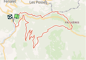
Trail Walking of 13.5 km to be discovered at Vaud, District d'Aigle, Bex. This trail is proposed by duamerg.

Description

Jusqu'à Fenières on longe l'Avançon, rivière très sauvage.
Entre Peufaire et Frenières on quitte enfin le goudron pour prendre un joli chemin mais très boueux et glissant (il avait beaucoup plu les jours précédents). A Leoutre, rejoindre la route pour trouver les panneaux pour Les Verneys. Après 10 minutes de goudron, la route est ensuite en terre. Aux Verneys belle vue sur le Chablais et le massif montagneux des Dents du Midi.Les chemins étant tellement boueux et glissants, retour par la route carrossable à partir des Verneys. Bonnes chaussures recommandées malgré les 2heures de routes goudronnées (pas top!).

Elevation profile

Points of interest

Positioning

Country:
Switzerland
Region :
Vaud
Department/Province :
District d'Aigle
Municipality :
Bex
Location:
Unknown
Start:(UTM)
348130 ; 5124986 (32T) N.

Trails nearby

Trail On foot Ollon - Sentier du Sel - Photo
On foot
PRO

On foot

Easy
Ollon, Vaud, District d'Aigle, Switzerland
4.5 km | 8 km-effort
1h 49min
No
Trail Walking Ollon - Le grand Chamossaire - Photo
Walking
perenhout

Walking

Medium
Ollon, Vaud, District d'Aigle, Switzerland
6.6 km | 15.6 km-effort
3h 48min
No
Trail Walking Ollon - st_bg_villars1 - Photo
Walking
GUIDE+

Walking

Very easy
Ollon, Vaud, District d'Aigle, Switzerland
5.6 km | 8.3 km-effort
Unknown
No
Trail Mountain bike Ollon - Bike32918 - Photo
Mountain bike
GUIDE+

Mountain bike

Very easy
Ollon, Vaud, District d'Aigle, Switzerland
22 km | 35 km-effort
Unknown
Yes
Trail Running Gryon - Mxalps - Photo
Running
gut72ch

Running

Difficult
Gryon, Vaud, District d'Aigle, Switzerland
61 km | 116 km-effort
10h 0min
No
Trail Running Gryon - Mxalps - Photo
Running
gut72ch

Running

Difficult
Gryon, Vaud, District d'Aigle, Switzerland
61 km | 116 km-effort
Unknown
No
Trail Running Bex - base 1 - Photo
Running
gregory.quin

Running

Very easy
Bex, Vaud, District d'Aigle, Switzerland
10.9 km | 17.3 km-effort
1h 36min
Yes
Trail Walking Saint-Maurice - Via Francigena - Photo
Walking
verbier

Walking

Very easy
Saint-Maurice, Valais/Wallis, Saint-Maurice, Switzerland
95 km | 158 km-effort
27h 24min
No
Trail Other activity Bex - Javerne - Photo
Other activity
pierrepraz

Other activity

Very easy
Bex, Vaud, District d'Aigle, Switzerland
11.8 km | 31 km-effort
Unknown
No


Close
My subscriptions