


TOUR DE KAYSERSBERG CHÂTEAU

jcschubnel
User
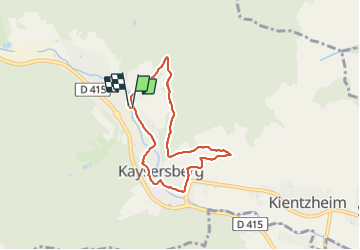

Length
6.1 km

Max alt
366 m

Uphill gradient
122 m
Km-Effort
7.7 km

Min alt
243 m

Downhill gradient
126 m
Boucle
Yes
Creation date :
2021-06-02 12:46:17.621
Updated on :
2021-06-02 16:06:21.949
1h43
Difficulty : Very easy

FREE GPS app for hiking
 SityTrail
IGN / Geographical institutes
SityTrail Plus
The world is yours!
About
Trail Walking of 6.1 km to be discovered at Grand Est, Haut-Rhin, Kaysersberg-Vignoble. This trail is proposed by jcschubnel.
Positioning
Country:
France
Region :
Grand Est
Department/Province :
Haut-Rhin
Municipality :
Kaysersberg-Vignoble
Location:
Kaysersberg
Start:(Dec)
Start:(UTM)
370308 ; 5334065 (32U) N.
Comments