


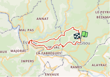
Coubisou 2

bouscaillou
User

Length
16.7 km

Max alt
516 m

Uphill gradient
492 m
Km-Effort
23 km

Min alt
312 m

Downhill gradient
516 m
Boucle
Yes
Creation date :
2021-06-13 07:52:37.994
Updated on :
2021-06-17 18:51:47.19
6h07
Difficulty : Very difficult

FREE GPS app for hiking
 SityTrail
IGN / Geographical institutes
SityTrail Plus
The world is yours!
About
Trail Walking of 16.7 km to be discovered at Occitania, Aveyron, Coubisou. This trail is proposed by bouscaillou.
Positioning
Country:
France
Region :
Occitania
Department/Province :
Aveyron
Municipality :
Coubisou
Location:
Unknown
Start:(Dec)
Start:(UTM)
478580 ; 4933512 (31T) N.
Comments