


La Roche de Solutré

GioA10
User
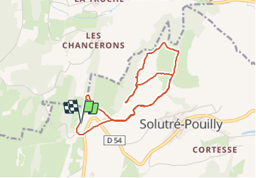

Length
5.1 km

Max alt
464 m

Uphill gradient
161 m
Km-Effort
7.2 km

Min alt
381 m

Downhill gradient
161 m
Boucle
Yes
Creation date :
2021-06-13 07:49:20.0
Updated on :
2021-07-12 12:12:43.139
1h46
Difficulty : Easy

FREE GPS app for hiking
 SityTrail
IGN / Geographical institutes
SityTrail Plus
The world is yours!
About
Trail Walking of 5.1 km to be discovered at Bourgogne-Franche-Comté, Saône-et-Loire, Solutré-Pouilly. This trail is proposed by GioA10.
Positioning
Country:
France
Region :
Bourgogne-Franche-Comté
Department/Province :
Saône-et-Loire
Municipality :
Solutré-Pouilly
Location:
Unknown
Start:(Dec)
Start:(UTM)
631905 ; 5128462 (31T) N.
Comments