


BEUIL TLUR DU MONT GRANIER

jpb83
User
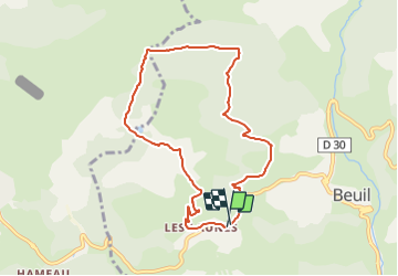

Length
8.5 km

Max alt
1769 m

Uphill gradient
287 m
Km-Effort
12.4 km

Min alt
1530 m

Downhill gradient
291 m
Boucle
Yes
Creation date :
2021-07-30 08:19:42.814
Updated on :
2021-07-30 08:19:44.874
2h48
Difficulty : Easy

FREE GPS app for hiking
 SityTrail
IGN / Geographical institutes
SityTrail Plus
The world is yours!
About
Trail Walking of 8.5 km to be discovered at Provence-Alpes-Côte d'Azur, Maritime Alps, Beuil. This trail is proposed by jpb83.
Positioning
Country:
France
Region :
Provence-Alpes-Côte d'Azur
Department/Province :
Maritime Alps
Municipality :
Beuil
Location:
Unknown
Start:(Dec)
Start:(UTM)
337543 ; 4883971 (32T) N.
Comments