


67.118 Poperinge - Over de Schreve

ADL339
User
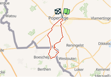

Length
17.5 km

Max alt
79 m

Uphill gradient
128 m
Km-Effort
19.2 km

Min alt
16 m

Downhill gradient
128 m
Boucle
Yes
Creation date :
2021-12-27 18:43:20.0
Updated on :
2021-12-27 18:43:21.296
4h21
Difficulty : Medium

FREE GPS app for hiking
 SityTrail
IGN / Geographical institutes
SityTrail Plus
The world is yours!
About
Trail Walking of 17.5 km to be discovered at Flanders, West Flanders, Poperinge. This trail is proposed by ADL339.
Positioning
Country:
Belgium
Region :
Flanders
Department/Province :
West Flanders
Municipality :
Poperinge
Location:
Poperinge
Start:(Dec)
Start:(UTM)
481424 ; 5633699 (31U) N.
Comments
Wandeling : 30.12.2021