


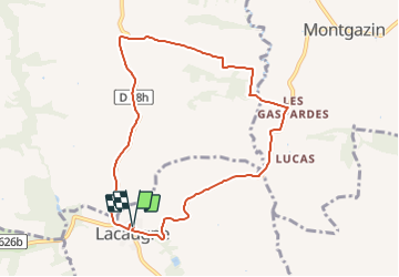
13895513-Lacaugne "Séré"

pidjam
User

Length
8.9 km

Max alt
306 m

Uphill gradient
188 m
Km-Effort
11.4 km

Min alt
219 m

Downhill gradient
190 m
Boucle
Yes
Creation date :
2022-02-06 08:23:34.362
Updated on :
2022-02-06 08:23:55.416
2h34
Difficulty : Medium

FREE GPS app for hiking
 SityTrail
IGN / Geographical institutes
SityTrail Plus
The world is yours!
About
Trail Walking of 8.9 km to be discovered at Occitania, Haute-Garonne, Lacaugne. This trail is proposed by pidjam.
Positioning
Country:
France
Region :
Occitania
Department/Province :
Haute-Garonne
Municipality :
Lacaugne
Location:
Unknown
Start:(Dec)
Start:(UTM)
359735 ; 4794162 (31T) N.
Comments