Trail Walking Marseille - The Pastré Country - Photo
© OpenStreetMap contributors
Length
Length
5.2 km
Max alt
Max alt
271 m
Uphill gradient
Uphill gradient
257 m
Km-Effort
Km-Effort  
8.7 km
Min alt
Min alt
16 m
Downhill gradient
Downhill gradient
259 m
Boucle
Boucle
Yes
Creation date :
2014-12-10 00:00:00.0
Updated on :
2014-12-10 00:00:00.0

(1 Reviews)

Walking
Walking
2h30
Difficulty : Medium

Scan this QR Code to open this trail in the SityTrail application

FREE GPS app for hiking

Logo SityTrail SityTrail

IGN / Geographical institutes

Download SityTrail from the App Store Download SityTrail from Google Play

Logo SityTrail SityTrail World

The world is yours!

Download SityTrail from the App Store Download SityTrail from Google Play Download SityTrail on Huawei AppGallery

About

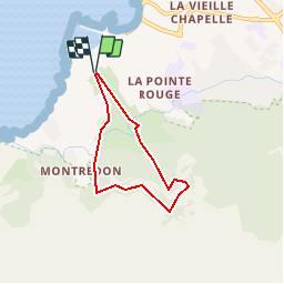
Trail Walking of 5.2 km to be discovered at Provence-Alpes-Côte d'Azur, Bouches-du-Rhône, Marseille. This trail is proposed by JN-PARTNERS.
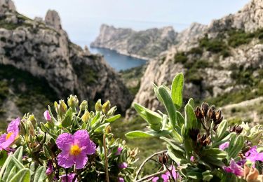
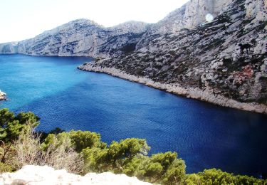
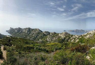
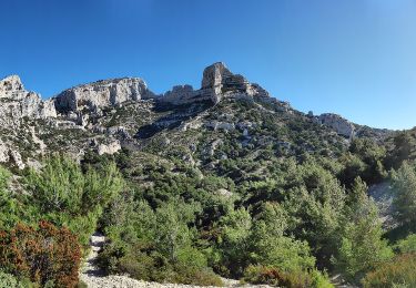
Description

The Pastré Country.

How to reach the starting point: from the Vieux-Port, take the metro to the Rond-Point du Prado, and then Bus No. 19 to the “Engalière” bus stop.

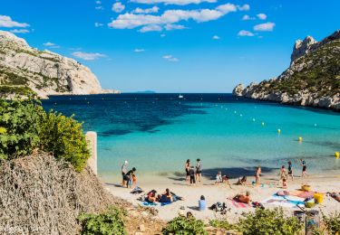
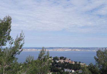
Points of interest: The Pastré Park, wildlife and forest trail circuit, views over Marseilles’ harbour and outlying islands.

On entering the park, take the tarmac path towards the Château Pastré (yellow trail n°2). To the right of the Château’s esplanade, walk past the traffic barrier and into the valley. Climb up through the valley via a narrow gorge filled with vegetation. At Point?, the path turns to the left and becomes steeper before crossing a cavity (Watch out! There are bumps along the path). At the end of this passage, the path turns right, follows the cliffs of the Rolland Grotto, and crosses the La Selle Forest until you come to Point?. When you reach the crossroads, take the path (black trail n°5) to the Valley of Les Aiguilles. At Point?, walk down the valley on the right-hand side (green trail n°1). On arriving back in the Pastré Park, walk past the houses on your left, cross the small irrigation canal and follow the main path back to your starting point.

Elevation profile

Positioning

Country:
France
Region :
Provence-Alpes-Côte d'Azur
Department/Province :
Bouches-du-Rhône
Municipality :
Marseille
Location:
8th Arrondissement
Start:(UTM)
692177 ; 4790176 (31T) N.

Comments

Please log in to post a review or rate the element


Très belle randonnée,avec des vues superbes sur Marseille ,Le Frioul et au loin la côte bleue.(un passage un peu délicat)


Trails nearby

Trail Mountain bike Marseille - OR-6270829--Marseille:Trilogie des Calanques - Photo
Mountain bike
GUIDE+

Mountain bike

Difficult
(1)
Marseille, Provence-Alpes-Côte d'Azur, Bouches-du-Rhône, France
28 km | 35 km-effort
3h 30min
Yes
Trail Walking Marseille - CE calanques morgiou et sugiton - Photo
Walking
myjackotte

Walking

Medium
(1)
Marseille, Provence-Alpes-Côte d'Azur, Bouches-du-Rhône, France
12.7 km | 19.3 km-effort
6h 33min
No
Trail Walking Marseille - Marseilleveyre - Photo
Walking
GUIDE
nadinebondoux

Walking

Very difficult
Marseille, Provence-Alpes-Côte d'Azur, Bouches-du-Rhône, France
13.8 km | 23 km-effort
6h 7min
Yes
Trail On foot Marseille - FR-6 - Photo
On foot
PRO

On foot

Easy
Marseille, Provence-Alpes-Côte d'Azur, Bouches-du-Rhône, France
7.7 km | 13.3 km-effort
3h 1min
No
Trail On foot Marseille - FR-5 - Photo
On foot
PRO

On foot

Easy
Marseille, Provence-Alpes-Côte d'Azur, Bouches-du-Rhône, France
4.8 km | 8.7 km-effort
1h 58min
No
Trail On foot Marseille - FR-4 - Photo
On foot
PRO

On foot

Easy
Marseille, Provence-Alpes-Côte d'Azur, Bouches-du-Rhône, France
4 km | 7.3 km-effort
1h 39min
No
Trail On foot Marseille - FR-1 - Photo
On foot
PRO

On foot

Easy
Marseille, Provence-Alpes-Côte d'Azur, Bouches-du-Rhône, France
3.4 km | 5.8 km-effort
1h 18min
No
Trail On foot Marseille - FR-1 - Photo
On foot
PRO

On foot

Easy
(1)
Marseille, Provence-Alpes-Côte d'Azur, Bouches-du-Rhône, France
7.2 km | 12.8 km-effort
2h 54min
No
Trail On foot Marseille - FR-1 - Photo
On foot
PRO

On foot

Easy
Marseille, Provence-Alpes-Côte d'Azur, Bouches-du-Rhône, France
3 km | 7.1 km-effort
1h 37min
No


Close
My subscriptions