


Itinerario "L’uomo e la vite"

SityTrail - itinéraires balisés pédestres
Tous les sentiers balisés d’Europe GUIDE+
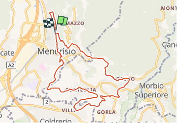

Length
11.2 km

Max alt
512 m

Uphill gradient
320 m
Km-Effort
15.5 km

Min alt
337 m

Downhill gradient
312 m
Boucle
Yes

Signpost
Creation date :
2022-02-14 08:56:03.782
Updated on :
2022-02-14 08:56:03.782
3h31
Difficulty : Easy

FREE GPS app for hiking
 SityTrail
IGN / Geographical institutes
SityTrail Plus
The world is yours!
About
Trail On foot of 11.2 km to be discovered at Ticino, Distretto di Mendrisio, Mendrisio. This trail is proposed by SityTrail - itinéraires balisés pédestres.
Description
Trail created by Ente Turistico del Mendrisiotto e Basso Ceresio.
Photos
"
data-pinterest-text="Pin it"
data-tweet-text="share on twitter"
data-facebook-share-url="https://www.sitytrail.com/en/trails/3106805-mendrisio--itinerario-xlxuomo-e-la-vitex/?photo=0#lg=1&slide=0"
data-twitter-share-url="https://www.sitytrail.com/en/trails/3106805-mendrisio--itinerario-xlxuomo-e-la-vitex/?photo=0#lg=1&slide=0"
data-googleplus-share-url="https://www.sitytrail.com/en/trails/3106805-mendrisio--itinerario-xlxuomo-e-la-vitex/?photo=0#lg=1&slide=0"
data-pinterest-share-url="https://www.sitytrail.com/en/trails/3106805-mendrisio--itinerario-xlxuomo-e-la-vitex/?photo=0#lg=1&slide=0">
 "
data-pinterest-text="Pin it"
data-tweet-text="share on twitter"
data-facebook-share-url="https://www.sitytrail.com/en/trails/3106805-mendrisio--itinerario-xlxuomo-e-la-vitex/?photo=1#lg=1&slide=1"
data-twitter-share-url="https://www.sitytrail.com/en/trails/3106805-mendrisio--itinerario-xlxuomo-e-la-vitex/?photo=1#lg=1&slide=1"
data-googleplus-share-url="https://www.sitytrail.com/en/trails/3106805-mendrisio--itinerario-xlxuomo-e-la-vitex/?photo=1#lg=1&slide=1"
data-pinterest-share-url="https://www.sitytrail.com/en/trails/3106805-mendrisio--itinerario-xlxuomo-e-la-vitex/?photo=1#lg=1&slide=1">
"
data-pinterest-text="Pin it"
data-tweet-text="share on twitter"
data-facebook-share-url="https://www.sitytrail.com/en/trails/3106805-mendrisio--itinerario-xlxuomo-e-la-vitex/?photo=1#lg=1&slide=1"
data-twitter-share-url="https://www.sitytrail.com/en/trails/3106805-mendrisio--itinerario-xlxuomo-e-la-vitex/?photo=1#lg=1&slide=1"
data-googleplus-share-url="https://www.sitytrail.com/en/trails/3106805-mendrisio--itinerario-xlxuomo-e-la-vitex/?photo=1#lg=1&slide=1"
data-pinterest-share-url="https://www.sitytrail.com/en/trails/3106805-mendrisio--itinerario-xlxuomo-e-la-vitex/?photo=1#lg=1&slide=1">
 "
data-pinterest-text="Pin it"
data-tweet-text="share on twitter"
data-facebook-share-url="https://www.sitytrail.com/en/trails/3106805-mendrisio--itinerario-xlxuomo-e-la-vitex/?photo=2#lg=1&slide=2"
data-twitter-share-url="https://www.sitytrail.com/en/trails/3106805-mendrisio--itinerario-xlxuomo-e-la-vitex/?photo=2#lg=1&slide=2"
data-googleplus-share-url="https://www.sitytrail.com/en/trails/3106805-mendrisio--itinerario-xlxuomo-e-la-vitex/?photo=2#lg=1&slide=2"
data-pinterest-share-url="https://www.sitytrail.com/en/trails/3106805-mendrisio--itinerario-xlxuomo-e-la-vitex/?photo=2#lg=1&slide=2">
"
data-pinterest-text="Pin it"
data-tweet-text="share on twitter"
data-facebook-share-url="https://www.sitytrail.com/en/trails/3106805-mendrisio--itinerario-xlxuomo-e-la-vitex/?photo=2#lg=1&slide=2"
data-twitter-share-url="https://www.sitytrail.com/en/trails/3106805-mendrisio--itinerario-xlxuomo-e-la-vitex/?photo=2#lg=1&slide=2"
data-googleplus-share-url="https://www.sitytrail.com/en/trails/3106805-mendrisio--itinerario-xlxuomo-e-la-vitex/?photo=2#lg=1&slide=2"
data-pinterest-share-url="https://www.sitytrail.com/en/trails/3106805-mendrisio--itinerario-xlxuomo-e-la-vitex/?photo=2#lg=1&slide=2">
 "
data-pinterest-text="Pin it"
data-tweet-text="share on twitter"
data-facebook-share-url="https://www.sitytrail.com/en/trails/3106805-mendrisio--itinerario-xlxuomo-e-la-vitex/?photo=3#lg=1&slide=3"
data-twitter-share-url="https://www.sitytrail.com/en/trails/3106805-mendrisio--itinerario-xlxuomo-e-la-vitex/?photo=3#lg=1&slide=3"
data-googleplus-share-url="https://www.sitytrail.com/en/trails/3106805-mendrisio--itinerario-xlxuomo-e-la-vitex/?photo=3#lg=1&slide=3"
data-pinterest-share-url="https://www.sitytrail.com/en/trails/3106805-mendrisio--itinerario-xlxuomo-e-la-vitex/?photo=3#lg=1&slide=3">
"
data-pinterest-text="Pin it"
data-tweet-text="share on twitter"
data-facebook-share-url="https://www.sitytrail.com/en/trails/3106805-mendrisio--itinerario-xlxuomo-e-la-vitex/?photo=3#lg=1&slide=3"
data-twitter-share-url="https://www.sitytrail.com/en/trails/3106805-mendrisio--itinerario-xlxuomo-e-la-vitex/?photo=3#lg=1&slide=3"
data-googleplus-share-url="https://www.sitytrail.com/en/trails/3106805-mendrisio--itinerario-xlxuomo-e-la-vitex/?photo=3#lg=1&slide=3"
data-pinterest-share-url="https://www.sitytrail.com/en/trails/3106805-mendrisio--itinerario-xlxuomo-e-la-vitex/?photo=3#lg=1&slide=3">
 "
data-pinterest-text="Pin it"
data-tweet-text="share on twitter"
data-facebook-share-url="https://www.sitytrail.com/en/trails/3106805-mendrisio--itinerario-xlxuomo-e-la-vitex/?photo=4#lg=1&slide=4"
data-twitter-share-url="https://www.sitytrail.com/en/trails/3106805-mendrisio--itinerario-xlxuomo-e-la-vitex/?photo=4#lg=1&slide=4"
data-googleplus-share-url="https://www.sitytrail.com/en/trails/3106805-mendrisio--itinerario-xlxuomo-e-la-vitex/?photo=4#lg=1&slide=4"
data-pinterest-share-url="https://www.sitytrail.com/en/trails/3106805-mendrisio--itinerario-xlxuomo-e-la-vitex/?photo=4#lg=1&slide=4">
"
data-pinterest-text="Pin it"
data-tweet-text="share on twitter"
data-facebook-share-url="https://www.sitytrail.com/en/trails/3106805-mendrisio--itinerario-xlxuomo-e-la-vitex/?photo=4#lg=1&slide=4"
data-twitter-share-url="https://www.sitytrail.com/en/trails/3106805-mendrisio--itinerario-xlxuomo-e-la-vitex/?photo=4#lg=1&slide=4"
data-googleplus-share-url="https://www.sitytrail.com/en/trails/3106805-mendrisio--itinerario-xlxuomo-e-la-vitex/?photo=4#lg=1&slide=4"
data-pinterest-share-url="https://www.sitytrail.com/en/trails/3106805-mendrisio--itinerario-xlxuomo-e-la-vitex/?photo=4#lg=1&slide=4">
 "
data-pinterest-text="Pin it"
data-tweet-text="share on twitter"
data-facebook-share-url="https://www.sitytrail.com/en/trails/3106805-mendrisio--itinerario-xlxuomo-e-la-vitex/?photo=5#lg=1&slide=5"
data-twitter-share-url="https://www.sitytrail.com/en/trails/3106805-mendrisio--itinerario-xlxuomo-e-la-vitex/?photo=5#lg=1&slide=5"
data-googleplus-share-url="https://www.sitytrail.com/en/trails/3106805-mendrisio--itinerario-xlxuomo-e-la-vitex/?photo=5#lg=1&slide=5"
data-pinterest-share-url="https://www.sitytrail.com/en/trails/3106805-mendrisio--itinerario-xlxuomo-e-la-vitex/?photo=5#lg=1&slide=5">
"
data-pinterest-text="Pin it"
data-tweet-text="share on twitter"
data-facebook-share-url="https://www.sitytrail.com/en/trails/3106805-mendrisio--itinerario-xlxuomo-e-la-vitex/?photo=5#lg=1&slide=5"
data-twitter-share-url="https://www.sitytrail.com/en/trails/3106805-mendrisio--itinerario-xlxuomo-e-la-vitex/?photo=5#lg=1&slide=5"
data-googleplus-share-url="https://www.sitytrail.com/en/trails/3106805-mendrisio--itinerario-xlxuomo-e-la-vitex/?photo=5#lg=1&slide=5"
data-pinterest-share-url="https://www.sitytrail.com/en/trails/3106805-mendrisio--itinerario-xlxuomo-e-la-vitex/?photo=5#lg=1&slide=5">
 "
data-pinterest-text="Pin it"
data-tweet-text="share on twitter"
data-facebook-share-url="https://www.sitytrail.com/en/trails/3106805-mendrisio--itinerario-xlxuomo-e-la-vitex/?photo=6#lg=1&slide=6"
data-twitter-share-url="https://www.sitytrail.com/en/trails/3106805-mendrisio--itinerario-xlxuomo-e-la-vitex/?photo=6#lg=1&slide=6"
data-googleplus-share-url="https://www.sitytrail.com/en/trails/3106805-mendrisio--itinerario-xlxuomo-e-la-vitex/?photo=6#lg=1&slide=6"
data-pinterest-share-url="https://www.sitytrail.com/en/trails/3106805-mendrisio--itinerario-xlxuomo-e-la-vitex/?photo=6#lg=1&slide=6">
"
data-pinterest-text="Pin it"
data-tweet-text="share on twitter"
data-facebook-share-url="https://www.sitytrail.com/en/trails/3106805-mendrisio--itinerario-xlxuomo-e-la-vitex/?photo=6#lg=1&slide=6"
data-twitter-share-url="https://www.sitytrail.com/en/trails/3106805-mendrisio--itinerario-xlxuomo-e-la-vitex/?photo=6#lg=1&slide=6"
data-googleplus-share-url="https://www.sitytrail.com/en/trails/3106805-mendrisio--itinerario-xlxuomo-e-la-vitex/?photo=6#lg=1&slide=6"
data-pinterest-share-url="https://www.sitytrail.com/en/trails/3106805-mendrisio--itinerario-xlxuomo-e-la-vitex/?photo=6#lg=1&slide=6">
 "
data-pinterest-text="Pin it"
data-tweet-text="share on twitter"
data-facebook-share-url="https://www.sitytrail.com/en/trails/3106805-mendrisio--itinerario-xlxuomo-e-la-vitex/?photo=7#lg=1&slide=7"
data-twitter-share-url="https://www.sitytrail.com/en/trails/3106805-mendrisio--itinerario-xlxuomo-e-la-vitex/?photo=7#lg=1&slide=7"
data-googleplus-share-url="https://www.sitytrail.com/en/trails/3106805-mendrisio--itinerario-xlxuomo-e-la-vitex/?photo=7#lg=1&slide=7"
data-pinterest-share-url="https://www.sitytrail.com/en/trails/3106805-mendrisio--itinerario-xlxuomo-e-la-vitex/?photo=7#lg=1&slide=7">
"
data-pinterest-text="Pin it"
data-tweet-text="share on twitter"
data-facebook-share-url="https://www.sitytrail.com/en/trails/3106805-mendrisio--itinerario-xlxuomo-e-la-vitex/?photo=7#lg=1&slide=7"
data-twitter-share-url="https://www.sitytrail.com/en/trails/3106805-mendrisio--itinerario-xlxuomo-e-la-vitex/?photo=7#lg=1&slide=7"
data-googleplus-share-url="https://www.sitytrail.com/en/trails/3106805-mendrisio--itinerario-xlxuomo-e-la-vitex/?photo=7#lg=1&slide=7"
data-pinterest-share-url="https://www.sitytrail.com/en/trails/3106805-mendrisio--itinerario-xlxuomo-e-la-vitex/?photo=7#lg=1&slide=7">
 "
data-pinterest-text="Pin it"
data-tweet-text="share on twitter"
data-facebook-share-url="https://www.sitytrail.com/en/trails/3106805-mendrisio--itinerario-xlxuomo-e-la-vitex/?photo=8#lg=1&slide=8"
data-twitter-share-url="https://www.sitytrail.com/en/trails/3106805-mendrisio--itinerario-xlxuomo-e-la-vitex/?photo=8#lg=1&slide=8"
data-googleplus-share-url="https://www.sitytrail.com/en/trails/3106805-mendrisio--itinerario-xlxuomo-e-la-vitex/?photo=8#lg=1&slide=8"
data-pinterest-share-url="https://www.sitytrail.com/en/trails/3106805-mendrisio--itinerario-xlxuomo-e-la-vitex/?photo=8#lg=1&slide=8">
"
data-pinterest-text="Pin it"
data-tweet-text="share on twitter"
data-facebook-share-url="https://www.sitytrail.com/en/trails/3106805-mendrisio--itinerario-xlxuomo-e-la-vitex/?photo=8#lg=1&slide=8"
data-twitter-share-url="https://www.sitytrail.com/en/trails/3106805-mendrisio--itinerario-xlxuomo-e-la-vitex/?photo=8#lg=1&slide=8"
data-googleplus-share-url="https://www.sitytrail.com/en/trails/3106805-mendrisio--itinerario-xlxuomo-e-la-vitex/?photo=8#lg=1&slide=8"
data-pinterest-share-url="https://www.sitytrail.com/en/trails/3106805-mendrisio--itinerario-xlxuomo-e-la-vitex/?photo=8#lg=1&slide=8">
 "
data-pinterest-text="Pin it"
data-tweet-text="share on twitter"
data-facebook-share-url="https://www.sitytrail.com/en/trails/3106805-mendrisio--itinerario-xlxuomo-e-la-vitex/?photo=9#lg=1&slide=9"
data-twitter-share-url="https://www.sitytrail.com/en/trails/3106805-mendrisio--itinerario-xlxuomo-e-la-vitex/?photo=9#lg=1&slide=9"
data-googleplus-share-url="https://www.sitytrail.com/en/trails/3106805-mendrisio--itinerario-xlxuomo-e-la-vitex/?photo=9#lg=1&slide=9"
data-pinterest-share-url="https://www.sitytrail.com/en/trails/3106805-mendrisio--itinerario-xlxuomo-e-la-vitex/?photo=9#lg=1&slide=9">
"
data-pinterest-text="Pin it"
data-tweet-text="share on twitter"
data-facebook-share-url="https://www.sitytrail.com/en/trails/3106805-mendrisio--itinerario-xlxuomo-e-la-vitex/?photo=9#lg=1&slide=9"
data-twitter-share-url="https://www.sitytrail.com/en/trails/3106805-mendrisio--itinerario-xlxuomo-e-la-vitex/?photo=9#lg=1&slide=9"
data-googleplus-share-url="https://www.sitytrail.com/en/trails/3106805-mendrisio--itinerario-xlxuomo-e-la-vitex/?photo=9#lg=1&slide=9"
data-pinterest-share-url="https://www.sitytrail.com/en/trails/3106805-mendrisio--itinerario-xlxuomo-e-la-vitex/?photo=9#lg=1&slide=9">

 "
data-pinterest-text="Pin it"
data-tweet-text="share on twitter"
data-facebook-share-url="https://www.sitytrail.com/en/trails/3106805-mendrisio--itinerario-xlxuomo-e-la-vitex/?photo=1#lg=1&slide=1"
data-twitter-share-url="https://www.sitytrail.com/en/trails/3106805-mendrisio--itinerario-xlxuomo-e-la-vitex/?photo=1#lg=1&slide=1"
data-googleplus-share-url="https://www.sitytrail.com/en/trails/3106805-mendrisio--itinerario-xlxuomo-e-la-vitex/?photo=1#lg=1&slide=1"
data-pinterest-share-url="https://www.sitytrail.com/en/trails/3106805-mendrisio--itinerario-xlxuomo-e-la-vitex/?photo=1#lg=1&slide=1">
"
data-pinterest-text="Pin it"
data-tweet-text="share on twitter"
data-facebook-share-url="https://www.sitytrail.com/en/trails/3106805-mendrisio--itinerario-xlxuomo-e-la-vitex/?photo=1#lg=1&slide=1"
data-twitter-share-url="https://www.sitytrail.com/en/trails/3106805-mendrisio--itinerario-xlxuomo-e-la-vitex/?photo=1#lg=1&slide=1"
data-googleplus-share-url="https://www.sitytrail.com/en/trails/3106805-mendrisio--itinerario-xlxuomo-e-la-vitex/?photo=1#lg=1&slide=1"
data-pinterest-share-url="https://www.sitytrail.com/en/trails/3106805-mendrisio--itinerario-xlxuomo-e-la-vitex/?photo=1#lg=1&slide=1">
 "
data-pinterest-text="Pin it"
data-tweet-text="share on twitter"
data-facebook-share-url="https://www.sitytrail.com/en/trails/3106805-mendrisio--itinerario-xlxuomo-e-la-vitex/?photo=2#lg=1&slide=2"
data-twitter-share-url="https://www.sitytrail.com/en/trails/3106805-mendrisio--itinerario-xlxuomo-e-la-vitex/?photo=2#lg=1&slide=2"
data-googleplus-share-url="https://www.sitytrail.com/en/trails/3106805-mendrisio--itinerario-xlxuomo-e-la-vitex/?photo=2#lg=1&slide=2"
data-pinterest-share-url="https://www.sitytrail.com/en/trails/3106805-mendrisio--itinerario-xlxuomo-e-la-vitex/?photo=2#lg=1&slide=2">
"
data-pinterest-text="Pin it"
data-tweet-text="share on twitter"
data-facebook-share-url="https://www.sitytrail.com/en/trails/3106805-mendrisio--itinerario-xlxuomo-e-la-vitex/?photo=2#lg=1&slide=2"
data-twitter-share-url="https://www.sitytrail.com/en/trails/3106805-mendrisio--itinerario-xlxuomo-e-la-vitex/?photo=2#lg=1&slide=2"
data-googleplus-share-url="https://www.sitytrail.com/en/trails/3106805-mendrisio--itinerario-xlxuomo-e-la-vitex/?photo=2#lg=1&slide=2"
data-pinterest-share-url="https://www.sitytrail.com/en/trails/3106805-mendrisio--itinerario-xlxuomo-e-la-vitex/?photo=2#lg=1&slide=2">
 "
data-pinterest-text="Pin it"
data-tweet-text="share on twitter"
data-facebook-share-url="https://www.sitytrail.com/en/trails/3106805-mendrisio--itinerario-xlxuomo-e-la-vitex/?photo=3#lg=1&slide=3"
data-twitter-share-url="https://www.sitytrail.com/en/trails/3106805-mendrisio--itinerario-xlxuomo-e-la-vitex/?photo=3#lg=1&slide=3"
data-googleplus-share-url="https://www.sitytrail.com/en/trails/3106805-mendrisio--itinerario-xlxuomo-e-la-vitex/?photo=3#lg=1&slide=3"
data-pinterest-share-url="https://www.sitytrail.com/en/trails/3106805-mendrisio--itinerario-xlxuomo-e-la-vitex/?photo=3#lg=1&slide=3">
"
data-pinterest-text="Pin it"
data-tweet-text="share on twitter"
data-facebook-share-url="https://www.sitytrail.com/en/trails/3106805-mendrisio--itinerario-xlxuomo-e-la-vitex/?photo=3#lg=1&slide=3"
data-twitter-share-url="https://www.sitytrail.com/en/trails/3106805-mendrisio--itinerario-xlxuomo-e-la-vitex/?photo=3#lg=1&slide=3"
data-googleplus-share-url="https://www.sitytrail.com/en/trails/3106805-mendrisio--itinerario-xlxuomo-e-la-vitex/?photo=3#lg=1&slide=3"
data-pinterest-share-url="https://www.sitytrail.com/en/trails/3106805-mendrisio--itinerario-xlxuomo-e-la-vitex/?photo=3#lg=1&slide=3">
 "
data-pinterest-text="Pin it"
data-tweet-text="share on twitter"
data-facebook-share-url="https://www.sitytrail.com/en/trails/3106805-mendrisio--itinerario-xlxuomo-e-la-vitex/?photo=4#lg=1&slide=4"
data-twitter-share-url="https://www.sitytrail.com/en/trails/3106805-mendrisio--itinerario-xlxuomo-e-la-vitex/?photo=4#lg=1&slide=4"
data-googleplus-share-url="https://www.sitytrail.com/en/trails/3106805-mendrisio--itinerario-xlxuomo-e-la-vitex/?photo=4#lg=1&slide=4"
data-pinterest-share-url="https://www.sitytrail.com/en/trails/3106805-mendrisio--itinerario-xlxuomo-e-la-vitex/?photo=4#lg=1&slide=4">
"
data-pinterest-text="Pin it"
data-tweet-text="share on twitter"
data-facebook-share-url="https://www.sitytrail.com/en/trails/3106805-mendrisio--itinerario-xlxuomo-e-la-vitex/?photo=4#lg=1&slide=4"
data-twitter-share-url="https://www.sitytrail.com/en/trails/3106805-mendrisio--itinerario-xlxuomo-e-la-vitex/?photo=4#lg=1&slide=4"
data-googleplus-share-url="https://www.sitytrail.com/en/trails/3106805-mendrisio--itinerario-xlxuomo-e-la-vitex/?photo=4#lg=1&slide=4"
data-pinterest-share-url="https://www.sitytrail.com/en/trails/3106805-mendrisio--itinerario-xlxuomo-e-la-vitex/?photo=4#lg=1&slide=4">
 "
data-pinterest-text="Pin it"
data-tweet-text="share on twitter"
data-facebook-share-url="https://www.sitytrail.com/en/trails/3106805-mendrisio--itinerario-xlxuomo-e-la-vitex/?photo=5#lg=1&slide=5"
data-twitter-share-url="https://www.sitytrail.com/en/trails/3106805-mendrisio--itinerario-xlxuomo-e-la-vitex/?photo=5#lg=1&slide=5"
data-googleplus-share-url="https://www.sitytrail.com/en/trails/3106805-mendrisio--itinerario-xlxuomo-e-la-vitex/?photo=5#lg=1&slide=5"
data-pinterest-share-url="https://www.sitytrail.com/en/trails/3106805-mendrisio--itinerario-xlxuomo-e-la-vitex/?photo=5#lg=1&slide=5">
"
data-pinterest-text="Pin it"
data-tweet-text="share on twitter"
data-facebook-share-url="https://www.sitytrail.com/en/trails/3106805-mendrisio--itinerario-xlxuomo-e-la-vitex/?photo=5#lg=1&slide=5"
data-twitter-share-url="https://www.sitytrail.com/en/trails/3106805-mendrisio--itinerario-xlxuomo-e-la-vitex/?photo=5#lg=1&slide=5"
data-googleplus-share-url="https://www.sitytrail.com/en/trails/3106805-mendrisio--itinerario-xlxuomo-e-la-vitex/?photo=5#lg=1&slide=5"
data-pinterest-share-url="https://www.sitytrail.com/en/trails/3106805-mendrisio--itinerario-xlxuomo-e-la-vitex/?photo=5#lg=1&slide=5">
 "
data-pinterest-text="Pin it"
data-tweet-text="share on twitter"
data-facebook-share-url="https://www.sitytrail.com/en/trails/3106805-mendrisio--itinerario-xlxuomo-e-la-vitex/?photo=6#lg=1&slide=6"
data-twitter-share-url="https://www.sitytrail.com/en/trails/3106805-mendrisio--itinerario-xlxuomo-e-la-vitex/?photo=6#lg=1&slide=6"
data-googleplus-share-url="https://www.sitytrail.com/en/trails/3106805-mendrisio--itinerario-xlxuomo-e-la-vitex/?photo=6#lg=1&slide=6"
data-pinterest-share-url="https://www.sitytrail.com/en/trails/3106805-mendrisio--itinerario-xlxuomo-e-la-vitex/?photo=6#lg=1&slide=6">
"
data-pinterest-text="Pin it"
data-tweet-text="share on twitter"
data-facebook-share-url="https://www.sitytrail.com/en/trails/3106805-mendrisio--itinerario-xlxuomo-e-la-vitex/?photo=6#lg=1&slide=6"
data-twitter-share-url="https://www.sitytrail.com/en/trails/3106805-mendrisio--itinerario-xlxuomo-e-la-vitex/?photo=6#lg=1&slide=6"
data-googleplus-share-url="https://www.sitytrail.com/en/trails/3106805-mendrisio--itinerario-xlxuomo-e-la-vitex/?photo=6#lg=1&slide=6"
data-pinterest-share-url="https://www.sitytrail.com/en/trails/3106805-mendrisio--itinerario-xlxuomo-e-la-vitex/?photo=6#lg=1&slide=6">
 "
data-pinterest-text="Pin it"
data-tweet-text="share on twitter"
data-facebook-share-url="https://www.sitytrail.com/en/trails/3106805-mendrisio--itinerario-xlxuomo-e-la-vitex/?photo=7#lg=1&slide=7"
data-twitter-share-url="https://www.sitytrail.com/en/trails/3106805-mendrisio--itinerario-xlxuomo-e-la-vitex/?photo=7#lg=1&slide=7"
data-googleplus-share-url="https://www.sitytrail.com/en/trails/3106805-mendrisio--itinerario-xlxuomo-e-la-vitex/?photo=7#lg=1&slide=7"
data-pinterest-share-url="https://www.sitytrail.com/en/trails/3106805-mendrisio--itinerario-xlxuomo-e-la-vitex/?photo=7#lg=1&slide=7">
"
data-pinterest-text="Pin it"
data-tweet-text="share on twitter"
data-facebook-share-url="https://www.sitytrail.com/en/trails/3106805-mendrisio--itinerario-xlxuomo-e-la-vitex/?photo=7#lg=1&slide=7"
data-twitter-share-url="https://www.sitytrail.com/en/trails/3106805-mendrisio--itinerario-xlxuomo-e-la-vitex/?photo=7#lg=1&slide=7"
data-googleplus-share-url="https://www.sitytrail.com/en/trails/3106805-mendrisio--itinerario-xlxuomo-e-la-vitex/?photo=7#lg=1&slide=7"
data-pinterest-share-url="https://www.sitytrail.com/en/trails/3106805-mendrisio--itinerario-xlxuomo-e-la-vitex/?photo=7#lg=1&slide=7">
 "
data-pinterest-text="Pin it"
data-tweet-text="share on twitter"
data-facebook-share-url="https://www.sitytrail.com/en/trails/3106805-mendrisio--itinerario-xlxuomo-e-la-vitex/?photo=8#lg=1&slide=8"
data-twitter-share-url="https://www.sitytrail.com/en/trails/3106805-mendrisio--itinerario-xlxuomo-e-la-vitex/?photo=8#lg=1&slide=8"
data-googleplus-share-url="https://www.sitytrail.com/en/trails/3106805-mendrisio--itinerario-xlxuomo-e-la-vitex/?photo=8#lg=1&slide=8"
data-pinterest-share-url="https://www.sitytrail.com/en/trails/3106805-mendrisio--itinerario-xlxuomo-e-la-vitex/?photo=8#lg=1&slide=8">
"
data-pinterest-text="Pin it"
data-tweet-text="share on twitter"
data-facebook-share-url="https://www.sitytrail.com/en/trails/3106805-mendrisio--itinerario-xlxuomo-e-la-vitex/?photo=8#lg=1&slide=8"
data-twitter-share-url="https://www.sitytrail.com/en/trails/3106805-mendrisio--itinerario-xlxuomo-e-la-vitex/?photo=8#lg=1&slide=8"
data-googleplus-share-url="https://www.sitytrail.com/en/trails/3106805-mendrisio--itinerario-xlxuomo-e-la-vitex/?photo=8#lg=1&slide=8"
data-pinterest-share-url="https://www.sitytrail.com/en/trails/3106805-mendrisio--itinerario-xlxuomo-e-la-vitex/?photo=8#lg=1&slide=8">
 "
data-pinterest-text="Pin it"
data-tweet-text="share on twitter"
data-facebook-share-url="https://www.sitytrail.com/en/trails/3106805-mendrisio--itinerario-xlxuomo-e-la-vitex/?photo=9#lg=1&slide=9"
data-twitter-share-url="https://www.sitytrail.com/en/trails/3106805-mendrisio--itinerario-xlxuomo-e-la-vitex/?photo=9#lg=1&slide=9"
data-googleplus-share-url="https://www.sitytrail.com/en/trails/3106805-mendrisio--itinerario-xlxuomo-e-la-vitex/?photo=9#lg=1&slide=9"
data-pinterest-share-url="https://www.sitytrail.com/en/trails/3106805-mendrisio--itinerario-xlxuomo-e-la-vitex/?photo=9#lg=1&slide=9">
"
data-pinterest-text="Pin it"
data-tweet-text="share on twitter"
data-facebook-share-url="https://www.sitytrail.com/en/trails/3106805-mendrisio--itinerario-xlxuomo-e-la-vitex/?photo=9#lg=1&slide=9"
data-twitter-share-url="https://www.sitytrail.com/en/trails/3106805-mendrisio--itinerario-xlxuomo-e-la-vitex/?photo=9#lg=1&slide=9"
data-googleplus-share-url="https://www.sitytrail.com/en/trails/3106805-mendrisio--itinerario-xlxuomo-e-la-vitex/?photo=9#lg=1&slide=9"
data-pinterest-share-url="https://www.sitytrail.com/en/trails/3106805-mendrisio--itinerario-xlxuomo-e-la-vitex/?photo=9#lg=1&slide=9">

Positioning
Country:
Switzerland
Region :
Ticino
Department/Province :
Distretto di Mendrisio
Municipality :
Mendrisio
Location:
Unknown
Start:(Dec)
Start:(UTM)
498998 ; 5080235 (32T) N.
Comments