


Aidâtes

bubuserge
User

Length
6.1 km

Max alt
880 m

Uphill gradient
91 m
Km-Effort
7.3 km

Min alt
838 m

Downhill gradient
90 m
Boucle
Yes
Creation date :
2022-03-10 10:24:02.0
Updated on :
2022-03-10 12:28:51.661
1h40
Difficulty : Medium

FREE GPS app for hiking
 SityTrail
IGN / Geographical institutes
SityTrail Plus
The world is yours!
About
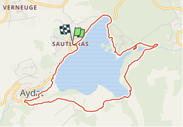
Trail Walking of 6.1 km to be discovered at Auvergne-Rhône-Alpes, Puy-de-Dôme, Aydat. This trail is proposed by bubuserge.
Positioning
Country:
France
Region :
Auvergne-Rhône-Alpes
Department/Province :
Puy-de-Dôme
Municipality :
Aydat
Location:
Unknown
Start:(Dec)
Start:(UTM)
498644 ; 5057011 (31T) N.
Comments