


wa36

My Switzerland
Optez pour le retour à la nature GUIDE+
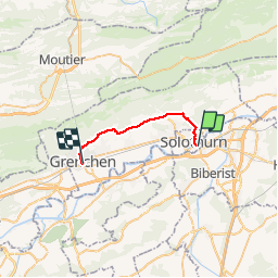

Length
17.7 km

Max alt
656 m

Uphill gradient
383 m
Km-Effort
23 km

Min alt
423 m

Downhill gradient
374 m
Boucle
No
Creation date :
2014-12-10 00:00:00.0
Updated on :
2014-12-10 00:00:00.0
7h33
Difficulty : Unknown

FREE GPS app for hiking
 SityTrail
IGN / Geographical institutes
SityTrail Plus
The world is yours!
About
Trail Walking of 17.7 km to be discovered at Solothurn, Bezirk Solothurn, Solothurn. This trail is proposed by My Switzerland.
Positioning
Country:
Switzerland
Region :
Solothurn
Department/Province :
Bezirk Solothurn
Municipality :
Solothurn
Location:
Unknown
Start:(Dec)
Start:(UTM)
389645 ; 5228920 (32T) N.
Comments